logo

1867. Chancellorville Prepared by Bvt. Brig. Gen. N. Michler . . . .1867

  • Chancellorville Prepared by Bvt. Brig. Gen. N. Michler . . . .1867

Chancellorville Prepared by Bvt. Brig. Gen. N. Michler . . . .1867 information:

Year of creation: 
Resolution size (pixels): 
 5228x4697 px
Disk Size: 
 8.03541MiB
Number of pages: 
 1
Place: 
 New York
Author: 

Print information. Print size (Width x height in inches):
Printing at 72 dpi 
  72.61 х 65.24
Printing at 150 dpi 
 34.85 х 31.31
Printing at 300 dpi 
 17.43 х 15.66

An example of detailing the file of this map of in a printable high-resolution:

Click to open in high resolution (open in new tab).
Attention! this is just the central piece (central area 960x960 px) of the map file!
This is an example, so that you can see and study the level of detail of a given map. The entire Map will be fully available after payment!

Chancellorville Prepared by Bvt. Brig. Gen. N. Michler . . . .1867

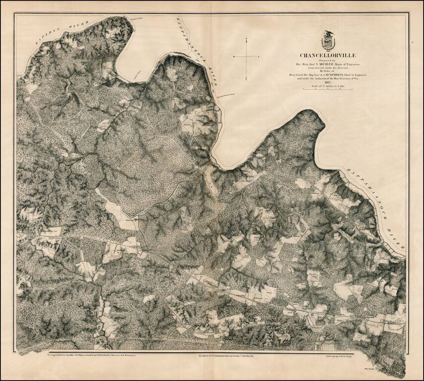
Scarce large format plan of the battle field and region around Chancellorville, showing the area south of the Rappahannock River.

Shows fortifications. Highly detailed. What is most noteworthy about the map is the inclusion of dozens of land owners on the map. Also shows roads, bridges, railroads, etc. Scale of 3 inches to 1 mile. Backed on conteporary linen.

Stephenson 528.3.

Special conditions for students!

If you are a student, write to us in telegram: @antiquemaps and indicate what material you need and for what work you need a map in high detail. We are ready to provide material on special terms. For students only!

Item information:

Year of creation:
Size:
5228x4697 px
Disk:
8.03541MiB
Number of pages:
1
Place:
New York
Author:
U.S. War Department.
$14.99

Related item