Map size in jpg-format: 21.097MiB
Click to open in high resolution (open in new tab).
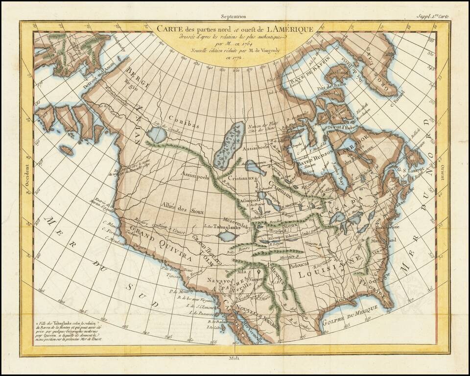
A fascinating map of North America, based upon a map by Thomas Engel.
Engel's map of North America was issued in his Memoires Observations Geographiques in 1765, and provides a fascinating look at the watercourses across North America, with no less than 4 rivers reaching from the Pacific to the Rocky Mountains and one nearly to the Mississippi, commencing near Puget Sound. Baron La Hontan's mythical River of the West is shown with only a short portage from L. de Tahuglanks across the Rockies to the source of the Mississippi. Two other rivers begin north of the Bering Strait and feed the mythical Lake Conibas popularized by Wytfliet in 1597, with Lake Michinipi, passing over top of the Rockies.
While no Northwest Passage is shown, the prospect is not foreclosed. The mid-American watercourses are no less interesting, with The Missouri, Mississippi and R. Rouge badly misprojected, but very much in evidence. The maps were issued following a long period of French/Jesuit exploration commencing with La Salle, Jolliet, Franquelin, Hennepin and La Hontan in the late 17th and early 18th Centuries and continuing with the systematic search reflected in the maps of Verendrye and others searching for the watercourse between the Mississippi and the Pacific. Wheat notes that among other interesting features, the entire west is labeled Allies de Sioux, undoubtedly a Jesuit observation.
If you are a student, write to us in telegram: @antiquemaps and indicate what material you need and for what work you need a map in high detail. We are ready to provide material on special terms. For students only!
![America [Manuscript Map Showing the Sea of the West!]](/map/small/41297dm.jpg)

![[Atlantis?] Ristretto Delle Carte presentate all' Academia delle Scienze di Parigi negli anni 1737 e 1752 dal Sig di Buache](/map/small/58667.jpg)