logo

1671. A Mapp or Generall Carte of the World Designed in two Plaine Hemisphers, By Monsieur Sanson Geographr to the French King and Rendered into English and Illustrated with Figures by Richard Blome By the Kings Especiall Command

  • A Mapp or Generall Carte of the World Designed in two Plaine Hemisphers, By Monsieur Sanson Geographr to the French King and Rendered into English and Illustrated with Figures by Richard Blome By the Kings Especiall Command

A Mapp or Generall Carte of the World Designed in two Plaine Hemisphers, By Monsieur Sanson Geographr to the French King and Rendered into English and Illustrated with Figures by Richard Blome By the Kings Especiall Command information:

Year of creation: 
Resolution size (pixels): 
 13212x9918 px
Disk Size: 
 37.7844MiB
Number of pages: 
 1
Place: 
 London
Author: 

Print information. Print size (Width x height in inches):
Printing at 72 dpi 
  183.5 х 137.75
Printing at 150 dpi 
 88.08 х 66.12
Printing at 300 dpi 
 44.04 х 33.06

An example of detailing the file of this map of in a printable high-resolution:

Click to open in high resolution (open in new tab).
Attention! this is just the central piece (central area 960x960 px) of the map file!
This is an example, so that you can see and study the level of detail of a given map. The entire Map will be fully available after payment!

A Mapp or Generall Carte of the World Designed in two Plaine Hemisphers, By Monsieur Sanson Geographr to the French King and Rendered into English and Illustrated with Figures by Richard Blome By the Kings Especiall Command

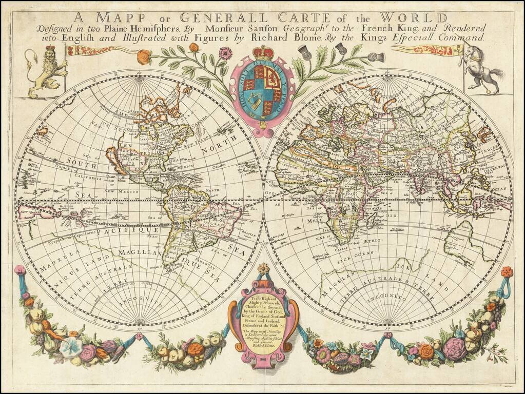
One of the Earliest Obtainable Large Format English World Maps.

Old color example of Richard Blome's world map, embellished with decorative features and a dedication to Charles II.

Beach is prominently mentioned in Australia, a marvelous reference to the mythical lands reported by Marco Polo. California is shown as an island.

Includes a number of other place names in Australia, including the Trial Rocks, Wilms and Jacobs R., Land of Concord 1615, F. Hotman's I, Edels 1619, Land of Lewn 1622, Pieter Nuyts Land 1627, and S. Peter and S Francois.

Blome's map breaks from both the Dutch tradition of Baroque embellishment and the French style of sparse surroundings of the hemispheres, creating a unique combination of decorative embellishment and symbols of the British Empire, making it a visually unique and striking world map. The engraving work is probably attributable to Francis Lamb, although Shirley surmised that Wenceslaus Hollar or Thomas Burnford may also have been the engraver.

Richard Blome published the first folio atlas which was engraved and printed in England. It was published by subscription and all of the maps included dedication to various British nobility. In this instance, the map is dedicated to Charles II, then King of England.

Shirley 455.

Special conditions for students!

If you are a student, write to us in telegram: @antiquemaps and indicate what material you need and for what work you need a map in high detail. We are ready to provide material on special terms. For students only!

Item information:

Year of creation:
Size:
13212x9918 px
Disk:
37.7844MiB
Number of pages:
1
Place:
London
Author:
Richard Blome.
$14.99

Related item