Map size in jpg-format: 240.663MiB
Click to open in high resolution (open in new tab).
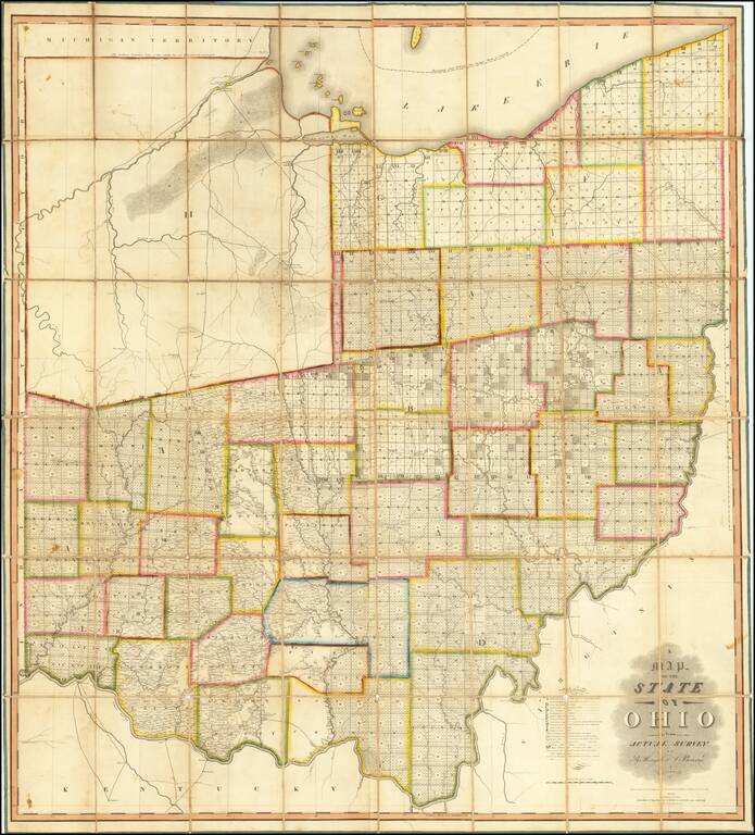
The First Great Map of Ohio
Fine example of the Hough & Bourne map of Ohio, published in Chillicothe, Ohio, prepared by John Melish and printed by Benjamin Tanner in Philadelphia in 1815.
Hough & Bourne's map of Ohio is the second large format map of Ohio (after Mansfield's map of 1807, which measures 30 x 22 inches) and a large format landmark in the history of the mapping of the Buckeye State.
Hough and Bourne were General Land Office surveyors, who took over and improved the work of the surveyor general of the United States, Jared F. Mansfield. Because of his position, Mansfield had access to original working materials of government agents. However, when he issued his Map of the State of Ohio From The Returns In The Office of the Surveyor General (1807), he issued it privately.
The lands are classified at the bottom right using a letter code, telling a number of stories of the early history of Ohio and the United States.
The Indian region in the northwest (labeled with an H and noted as "Unsurveyed lands on which the Indian Title is not yet extinguished) largely open, dissected by a series of military roads, with distances between major points and forks shown. On the Miami River, the map locates Ft. Meigs, the Old British Fort and the British Batteries from the battle fought on May 5, 1813. Fort Defiance, Fort Wayne (Indiana), Ft. St. Mary, Ft. Amanda, Ft. Jennings, Ft. Finley, Ft. Stephenson, Ft. Seneca, Ft. Ferres, Ft. Necessity, Ft. McArthur, and Ft. Brown are all shown in the far northwestern area of the state.
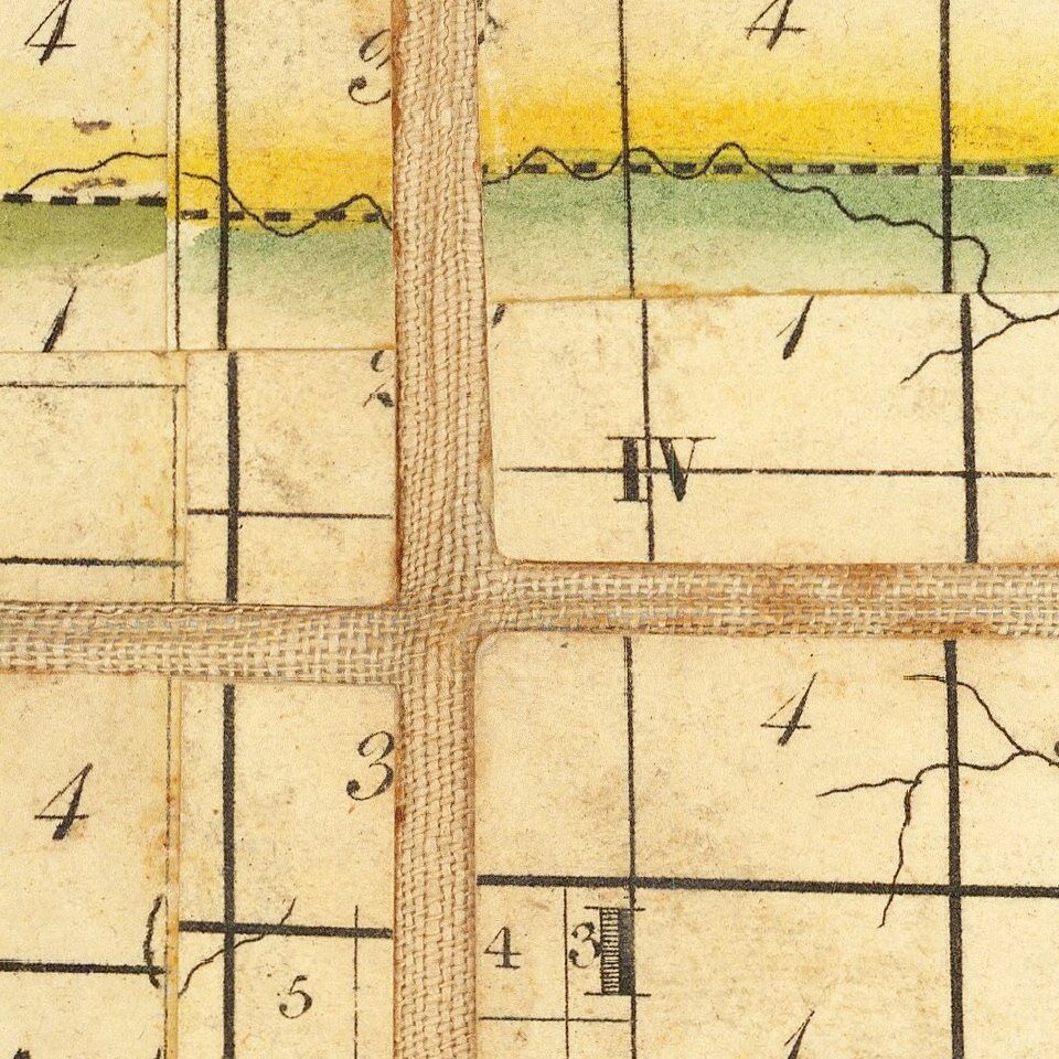
Negro Town (see section below), Crane's Town and Crawsford's defeat are shown in the Sandusky River, with Round Head's Town and Solomon's Town shown further south.
Hough and Bourne acquired the copyright to Mansfield's work after he was killed in the War of 1812, then substantially expanded the map and format, based on their own work.
Ristow notes that the Hough & Bourne map is "the first map of Ohio to show all the actual surveys within the inhabited part of the state." As noted by Reese & Miles:
This large and detailed map of Ohio shows rapid progress of the township grid from the original surveys in the eastern part of the state in the 1790s. In southern Ohio some of the areas claimed by land companies established in the colonial period were surveyed and parceled out prior to 1795, and their irregular patterns, conforming more to topography than geometry, are in strong contrast to the tyranny of the grid. Similar collisions of old and new systems of land tenure and surveying can be seen elsewhere in the country, particularly along the lower Mississippi where a pattern of plantation strips running back from the river established by the French settlers encounters the later American squares. Such patterns in the landscape are best seen from airplanes; they reward the traveler with an atlas and a window seat.Negro Town
The Negro Town settlement likely begins with the marriage of George Wright (likely from Kentucky), who was captured by the Shawnee near Lexington and sold to a Wyandot Tribe, who in turn married "Betty," a black woman brought from Africa by French slave traders first to Martinique and then to Philadelphia, where she was purchased by a Delaware Indian, who later sold her to the Wyandot. Shortly before 1800, Betty and George Wright married and had 2 daughters, Betty (1806) and Sarah (1808). The first notice of Negrotown was recorded as early as 1808, in the diary of Moravian Missionary Abraham Luckenbach, who noted:
After we passed by a place where 20 years ago was an Indian town, we came to Negrotown which contains six or seven Negro families which already for a long time lived amongst the Indians and accepted their way of life. Here we descended and entered the house where a white man named Wright lived who does silver work for the Indians… He offered us some corn bread and coffee as it is drunk among their people, and it was served by a Negro woman who speaks well English, and immediately excused herself that she could serve us only a little that was left over from breakfast, which we accepted according to Indian custom as if we had not already had our breakfast and did not reject it…We continued on to an old Wyandott Town called Crane Town upstream one-and-one-half miles from Negrotown.
is connected with the story of John Stewart, an African American missionary from Virginia, who founded the first church in Upper Sandusky around 1816. Stewart was apparently robbed in Ohio and fell on hard times, finding his salvation in a Methodist Camp in Marietta, Ohio, where he converted and soon thereafter became a licensed preacher. According to Meyers & Walker:
As early as 1811, there was a small settlement called Negro Town in what would become Wyandot County. Nothing is known of its founding. James Barton recalled forty years later that when he arrived in the area, it consisted of a group of log huts "inhabited by Indians, except and old Negro called "Tom" and his family, and a white man named Wright who was married to Tom's daughter."
In 1816, John Stewart, a free-born African American, presented himself to the Wyandots living in the vicinity, intent on preaching the Gospel. He soon founded the first church in Upper Sandusky. Two years later, he married Polly Carter, a black resident of Negro Town. According to Larry Hancks, "A 60 acre farm [was] purchased for John and Polly Stewart adjacent to the Wyandots' Grand Reserve with funds raised by Methodist Bishop McKendree . . .
Rarity
The map is very rare on the market. Since 1940, we note only the Streeter copy (1967) and the Dush Copy (Cowans - 1997).
If you are a student, write to us in telegram: @antiquemaps and indicate what material you need and for what work you need a map in high detail. We are ready to provide material on special terms. For students only!