Map size in jpg-format: 22.3235MiB
Click to open in high resolution (open in new tab).
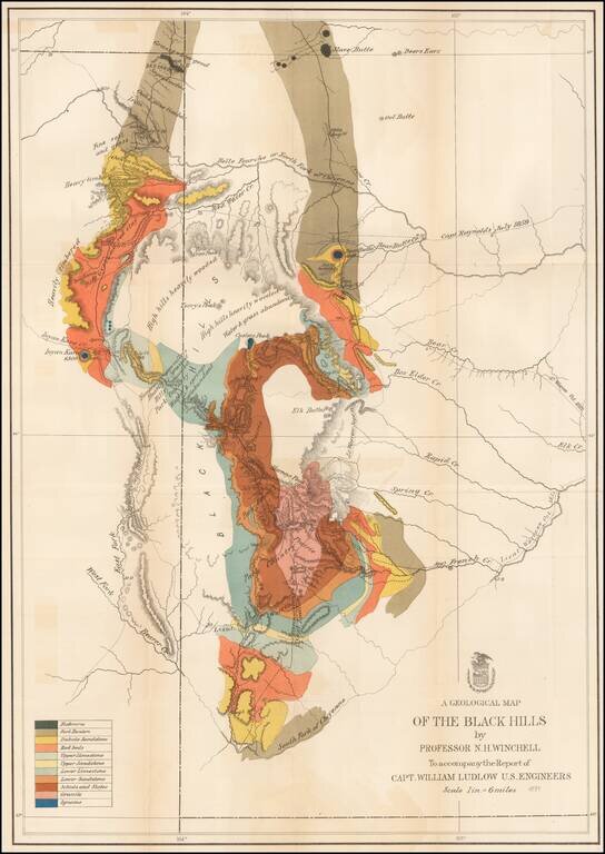
Important early geological survey map of the Black Hills region, undertaken by William Ludlow, while under the command of George Custer.
In 1874, a large group of cavalrymen under the command of Lt. Col. George Armstrong Custer moved into the Black Hills region of Dakota Territory. Though officially American Indian Territory according to the 1868 Treaty of Laramie, rumors had been circulating since the early 19th century that this region harbored rich deposits of gold. Custer and his men were sent to investigate. The expedition included William Ludlow, an officer of the Army Corps of engineers, whose commission was to explore and survey the region, identifying in the process if the rumored gold did indeed exist. Ludlow and Custer traveled west from Fort Lincoln on the Missouri River (near Bismarck), to the Powder River, then on to the Black Hills. The map meticulously documents the survey triangulation points and encampments. Ludlow offers commentary on the territory such as 'High hills heavily timbered water and grass abundant,' 'grass and water good,' 'bad lands' and 'soil and loose dry clay.' Ultimately, Custer and his men did find gold in the Black Hills, leading to the 1876 Black Hills Gold Rush.
If you are a student, write to us in telegram: @antiquemaps and indicate what material you need and for what work you need a map in high detail. We are ready to provide material on special terms. For students only!