
![[Abraham Bradley Letter to Ezekiel Williams Jr. -- Dated April 22, 1797]](/map/small/67271.jpg)
Distributing The First Postal Map of the United States To Local Agents Fascinating one page letter from Abraham Bradley, Jr. to Connecticut Postmaster Ezekiel Williams Jr., sent from Philadelphia to Hartford, Connecticut on April 22, 1797, discussing...
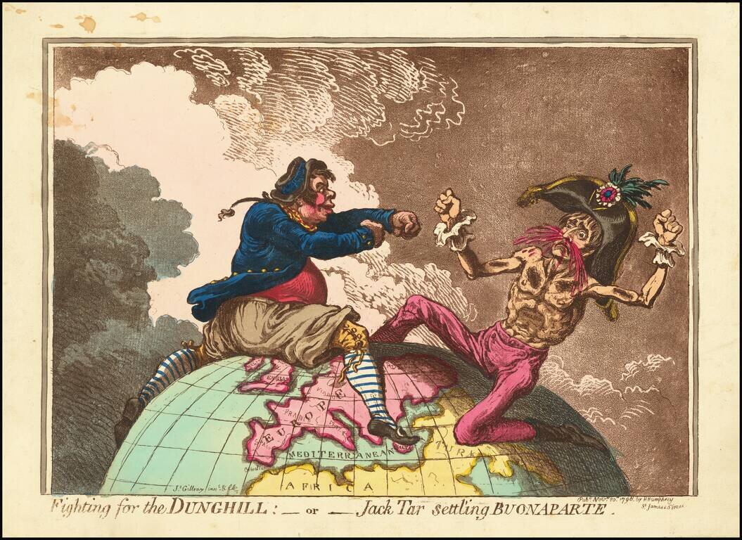
"[T]he earliest of Gillray’s portrayals of Bonaparte as the symbolic personification of France." - RMG Catalog One of the great cartographic caricatures of the Georgian Era. This lampoon of Napoleon after Nelson's victory was drawn by James Gillray...
![[Manuscript Student Draftsman Map]](/map/small/59815.jpg)
An impressive manuscript map made by a student draftsman, probably a young military officer, probably to demonstrate his capacities as a formally trained mapmaker. The map encompasses a diverse range of mapmaking skills, such as rendering...

Fascinating engraving showing natives driving Indian Elephants into a Keddah, based upon an oil painting by Samuel Howett.
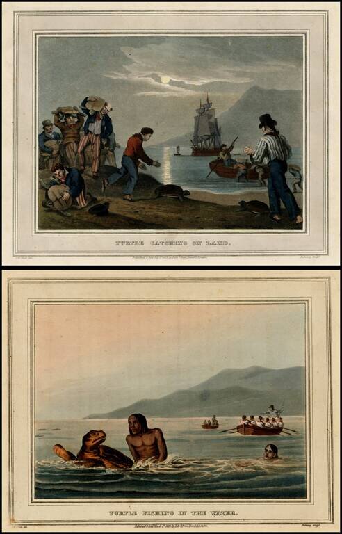
Fine pair of early 19th Century Aquatints, showing two different ways of hunting turtles. From Foreign Field Sports. Engraved imagse, printed on Whatman paper by ohn Heaviside Clark (1770- 1863). Aquatint by M. Dubourg.
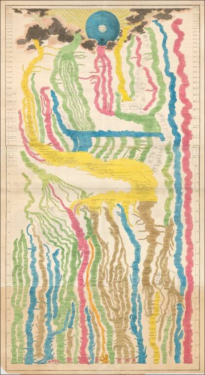
Large and beautiful hand-colored engraved map of time, on three sheets, joined. The chart derives from that of Frederic Strass (a common source for these so-called "time maps"). The initial peoples on the chart are Italians, Greeks, the people of Asia...
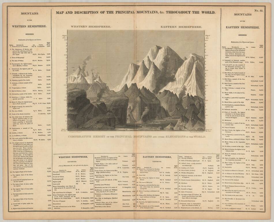
Scarce comparative mountains chart, from Carey & Lea's American Atlas. This is likely the earliest Mountains chart to appear in an American Atlas. Includes over 100 mountains and elevations, including some volcanoes.

Interesting image illustrating the comparative lengths of Rivers, from Fielding Lucas' New and Elegant Atlas.
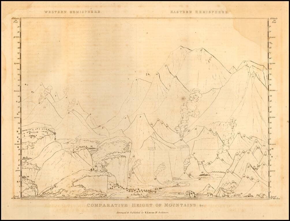
Interesting uncolored image illustrating the comparative heights of mountains, volcanoes, etc. from Fielding Lucas' New and Elegant Atlas.
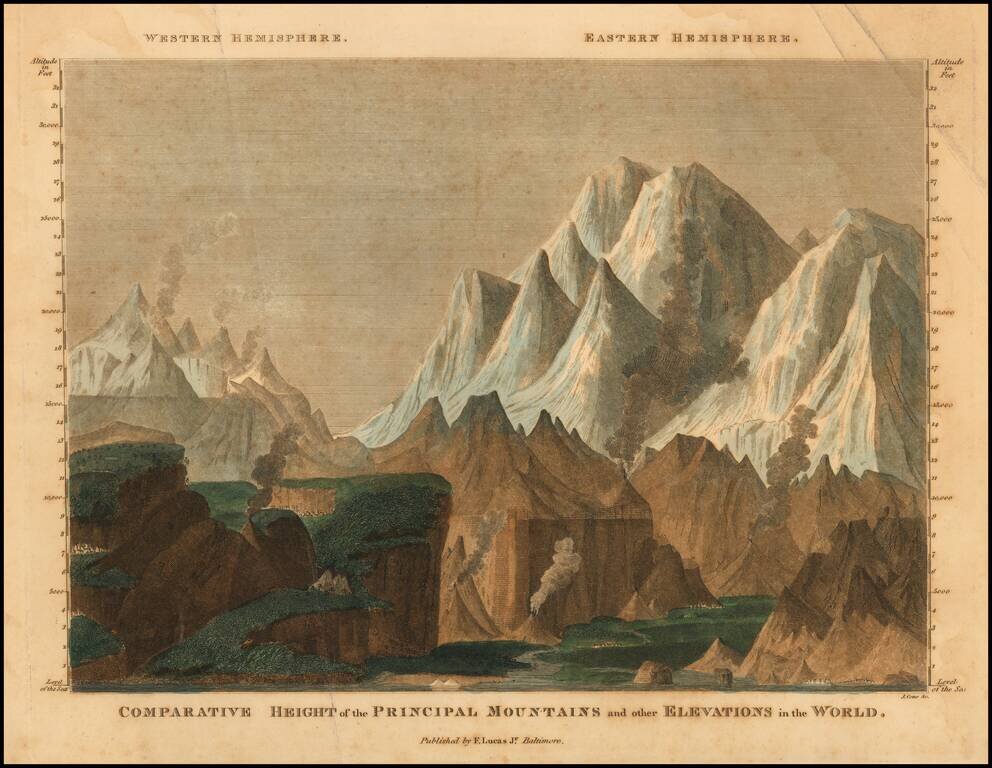
Interesting image illustrating the comparative heights of mountains, volcanoes, etc. from Fielding Lucas' New and Elegant Atlas.
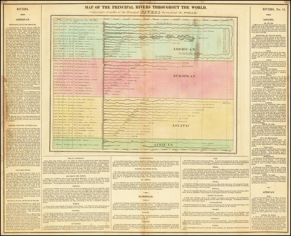
Interesting double-page engraved map of the rivers of the world, representing their comparative lengths (or the lengths as they were then known). The rivers are separated by continent -- American, European, Asiatic, and African. There is virtually no...

Hand-colored antique engraved letterpress chart of time, focused specifically on the Americas. This work traces the history of geographical regions within North and South America from the discovery of Columbus onward to 1822. The chart provides an...
![[Rivers of the World] Carte Des Principales Rivieres Du Globe](/map/small/62453.jpg)
Scarce map illustrating the lengths of the principal rivers of the world.
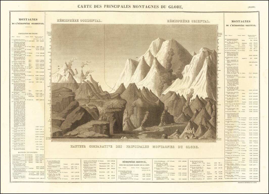
Nice example of Buchon's map of the Principle Mountains in the World, published in Paris in 1825. The map is divided into hemispheres, with extensive historical details.

Interesting image illustrating the comparative heights of various mountains and volcanoes, with a reference chart by continent below, showing heights. From Finley's New General Atlas.

A Rare Early Robert Havell, Jr. aquatint Rare illustration of the comparative heights of the various buildings and public places on the River Thames, published by Frederick Wood& William Moffat. While extremely rare, the map was apparently...