John William Norie (1772 – 1843) was a publisher of nautical books held in high regard by his contemporaries. He also specialized in nautical charts and was a mathematician. Norie was born in Wapping, London, the eldest of eight children.
Norie had an apptitude for navigation and chart making. His first work was published in 1796, The Description and Use of Hadley's Quadrant, by William Heather, a chart and instrument seller. Heather then took Norie on as a chart maker and allowed him to run a nautical academy out of Heather's premises on Leadenhall Street. He continued to work for Heather, working out of his shop.
Norie published many works, but the most famous were A Complete Set of Nautical Tables (1803) and the Epitome of Practical Navigation (1805). Both were reissued throughout the nineteenth century, usually together. The Tables are still issued today. The Epitome became the standard work on navigation; it was so famous that authors C. S. Forester and Jack London both mention the book in their fiction. In addition to the Epitome, Norie wrote the The shipwright's vade-mecum (1822), Plates Descriptive of the Maritime Flags of All Nations (1838), and The naval gazetteer, biographer, and chronologist; new and improved (1842). He also provided pilots with charts that covered practically the entire world's seas--the famous blue-back charts.
Norie partnered with a financial backer, George Wilson, to buy Heather's business upon Heather's death in 1813. In addition to the nautical academy and the copyright to his books, Norie prospered from the growing business, which he managed. The shop, operating under the sign of the Wooden Midshipman, was called the Navigation Warehouse. It featured in Charles Dickens' Dombey and Son.
Norie retired in 1840. He sold his shares in the business and moved to Edinburgh. He died there, at the age of 71, on Christmas Eve 1843. His company was renamed Norie & Wilson after his retirement. In 1903, the firm merged with rivals and became Imray, Laurie, Norie & Wilson. It is still in business today.

Using the Stars to Understand Latitude—A Rare Instructional Star Chart Rare, commercially-published star chart, made for teaching constellations and the path of the sun through the celestial sphere, the ecliptic, to students of astronomy. Once these...
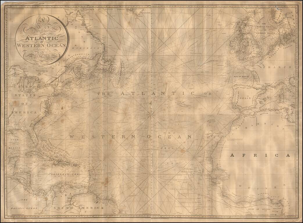
Nice example of William Heather's scarce chart of the Atlantic Ocean, offered here in a "New Edition" by John W. Norie and dated 1828. One of the best large format charts of the Atlantic published in the first half of the 19th Century, Heather's chart...
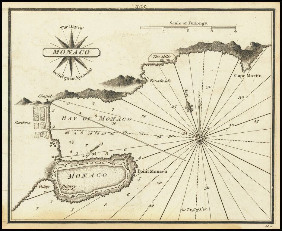
Very scarce miniature engraved chart of the town of Monaco. This is possibly the first English printed chart of the famous city-state of Monaco. The chart includes soundings in the bay of Monaco, the famous citadel, information about the...
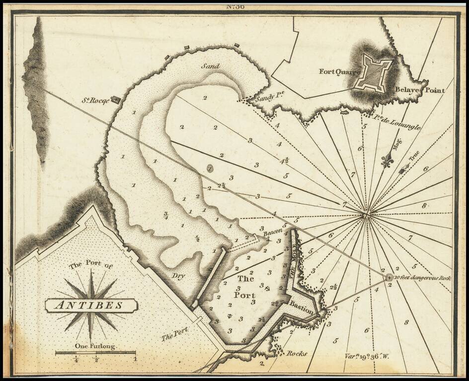
Very scarce miniature engraved chart of the port of Antibes, in the south of France. This is possibly the first English printed chart of the famous port of Antibes, now sometimes known as Port Vauban, one of the great private yacht in the south of...
![[Cannes, Pointe Croisette, Ile Sainte Marguerite, Ile Saint-Honorat]](/map/small/70870.jpg)
Rare Chart of the Islands near Cannes Very scarce miniature engraved chart of Pointe Croisette, Ile Sainte Marguerite, Ile Saint-Honorat on the French Riviera. The chart includes soundings i and sailing directions, the Ile Sainte Marguerite citadel,...
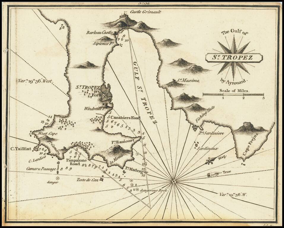
Rare miniature chart of St. Tropez, France, published by William Heather in London. The chart is oriented with west at the top. It includes good detail of the region of St. Tropez, illustrating how much has changed over the more than 200 years since...
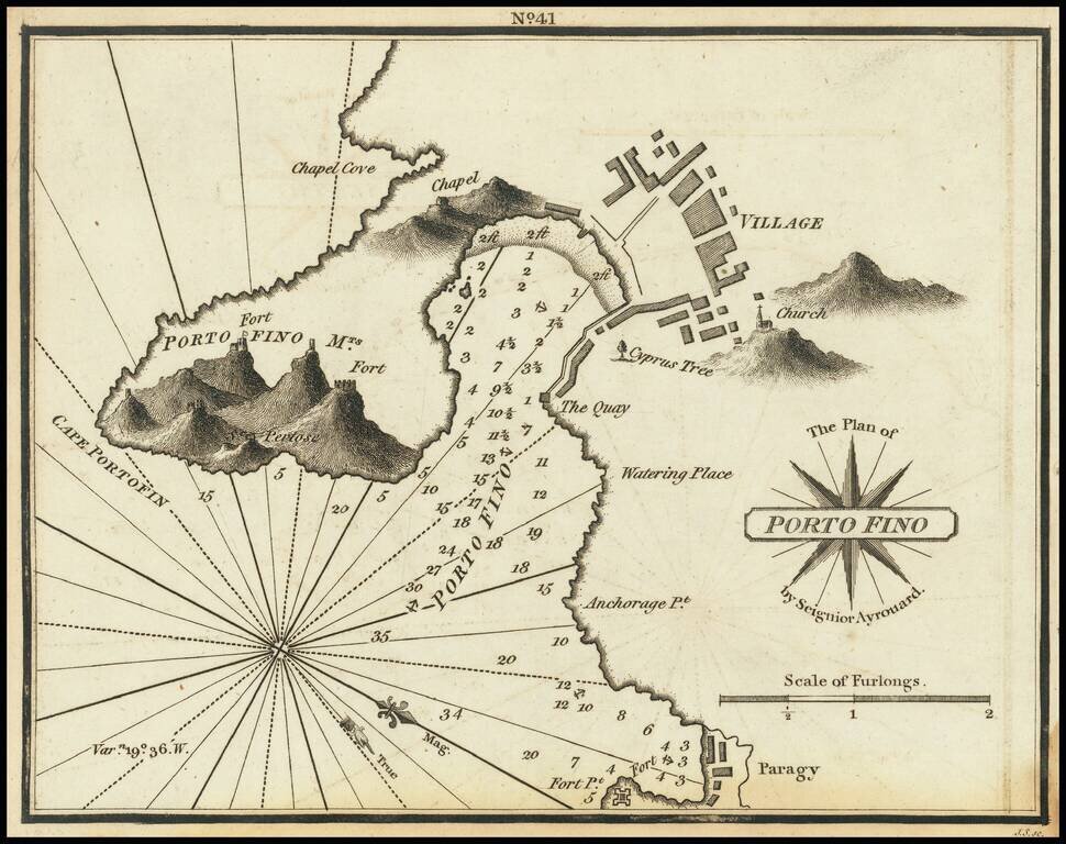
Rare chart of Portofino, Italy, published by William Heather in London. The chart is oriented with west at the top. Includes soundings, some topographical features, anchorages, a plan of the village, and several other points of interest. The chart...
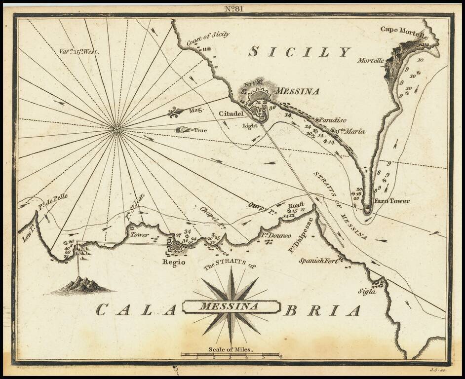
Rare chart of the Strait of Messina, separating Sicily and Calabria in Italy, published by William Heather in London. The chart is oriented with west at the top. It includes soundings, some topographical features, anchorages, and currents. The towns...
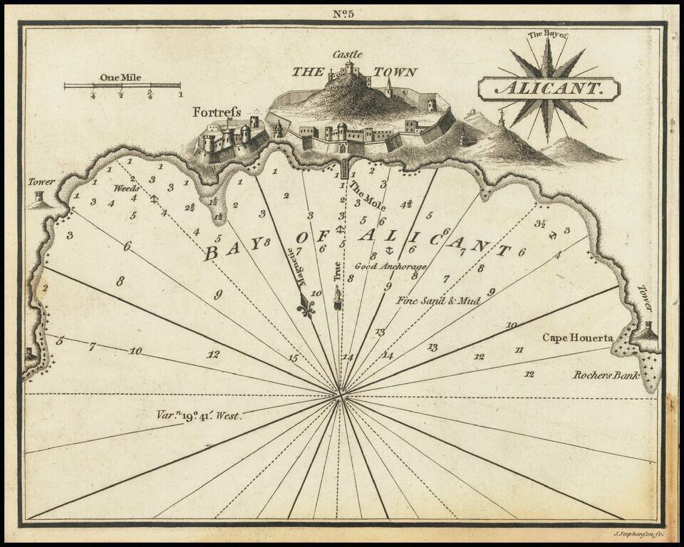
Rare chart of Alicante, Spain, published by William Heather in London. The chart is oriented with northwest at the top. Includes soundings, some topographical features, anchorages, a pictorial representation of the town and fortress, and several...
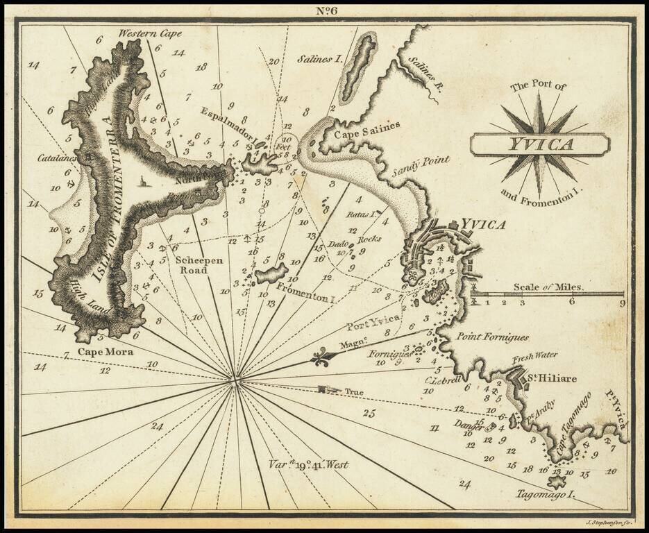
Very scarce miniature engraved chart of the town of Ibiza, on the Balearic Island of Ibiza. This is possibly the first English printed chart of the famous Spanish port city of Ibiza, now so well known for its world-class nightlife. The chart...
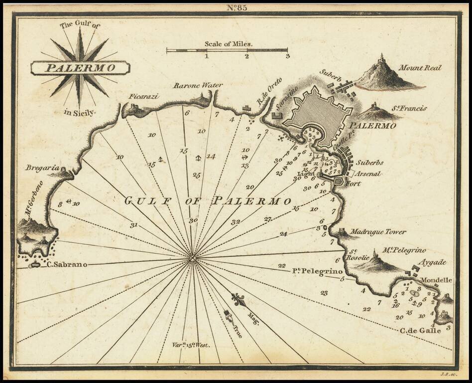
Rare chart of Palermo, published by William Heather in London. The chart is oriented with southwest at the top. It includes soundings, some topographical features, anchorages, and currents. Palermo is shown, along with several mountains. Rarity...