G. W. & C. B. Colton was a prominent family firm of mapmakers who were leaders in the American map trade in the nineteenth century. Its founder, Joseph Hutchins Colton (1800-1893), was a Massachusetts native. Colton did not start in the map trade; rather, he worked in a general store from 1816 to 1829 and then as a night clerk at the United States Post Office in Hartford, Connecticut. By 1830, he was in New York City, where he set up his publishing business a year later.
The first printed item with his imprint is dated 1833, a reprint of S. Stiles & Company’s edition of David Burr’s map of the state of New York. He also printed John Disturnell’s map of New York City in 1833. Colton’s next cartographic venture was in 1835, when he acquired the rights to John Farmer’s seminal maps of Michigan and Wisconsin. Another early and important Colton work is his Topographical Map of the City and County of New York and the Adjacent Country (1836). In 1839, Colton began issuing the Western Tourist and Emigrant’s Guide, which was originally issued by J. Calvin Smith.
During this first decade, Colton did not have a resident map engraver; he relied upon copyrights purchased from other map makers, most often S. Stiles & Company, and later Stiles, Sherman & Smith. Smith was a charter member of the American Geographical and Statistical Society, as was John Disturnell. This connection would bear fruit for Colton during the early period in his career, helping him to acquire the rights to several important maps. By 1850, the Colton firm was one of the primary publishers of guidebooks and immigrant and railroad maps, known for the high-quality steel plate engravings with decorative borders and hand watercolors.
In 1846, Colton published Colton’s Map of the United States of America, British Possessions . . . his first venture into the wall map business. This work would be issued until 1884 and was the first of several successful wall maps issued by the firm, including collaborative works with D.G. Johnson. From the 1840s to 1855, the firm focused on the production of railroad maps. Later, it published a number of Civil War maps.
In 1855, Colton finally issued his first atlas, Colton’s Atlas of the World, issued in two volumes in 1855 and 1856. In 1857 the work was reduced to a single volume under the title of Colton’s General Atlas, which was published in largely the same format until 1888. It is in this work that George Woolworth (G. W.) Colton’s name appears for the first time.
Born in 1827 and lacking formal training as a mapmaker, G. W. joined his father’s business and would later help it to thrive. His brother Charles B. (C. B.) Colton would also join the firm. Beginning in 1859, the General Atlas gives credit to Johnson & Browning, a credit which disappears after 1860, when Johnson & Browning launched their own atlas venture, Johnson’s New Illustrated (Steel Plate) Family Atlas, which bears Colton’s name as the publisher in the 1860 and 1861 editions.
J.H. Colton also published a number of smaller atlases and school geographies, including his Atlas of America (1854-56), his Illustrated Cabinet Atlas (1859), Colton’s Condensed Cabinet Atlas of Descriptive Geography (1864) and Colton’s Quarto Atlas of the World (1865). From 1850 to the early 1890s, the firm also published several school atlases and pocket maps. The firm continued until the late 1890s, when it merged with a competitor and then ceased to trade under the name Colton.
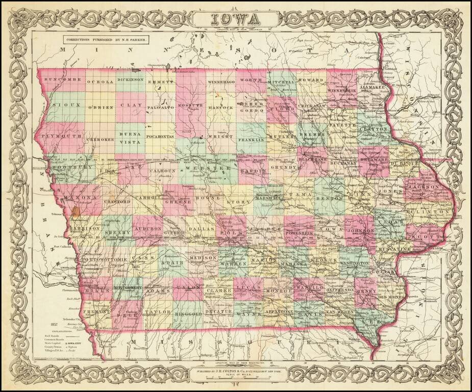
Scarce early separately issued map of Iowa, pre-dating the first edition Colton's atlas map of Iowa. An attractive and detailed map of Iowa with an ornate border. It is colored by counties and shows cities, towns, railroads, rivers, and lakes.
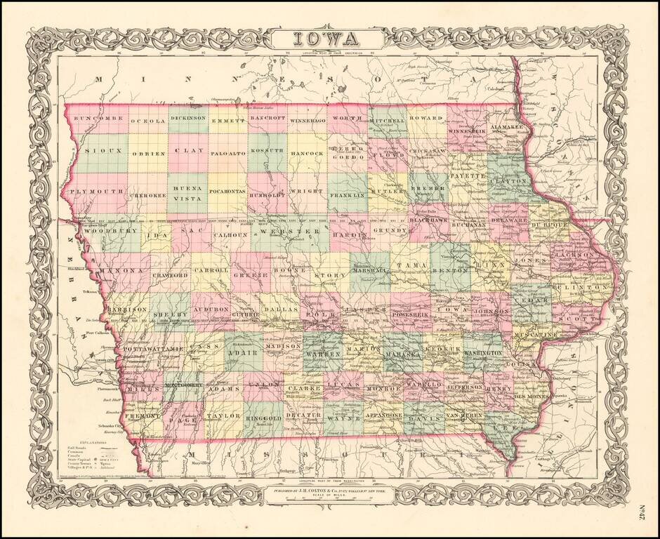
Attractive and detailed early map of Iowa with an ornate border. The map is hand colored by counties and shows cities, towns, railroads, rivers, and lakes. From an early edition of JH Colton's Atlas. Wide margins. JH Colton was one of the pre-eminent...
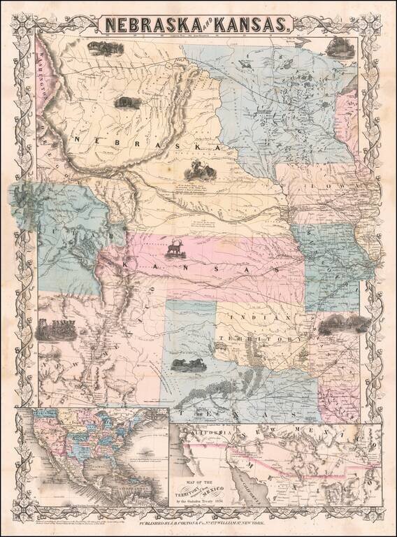
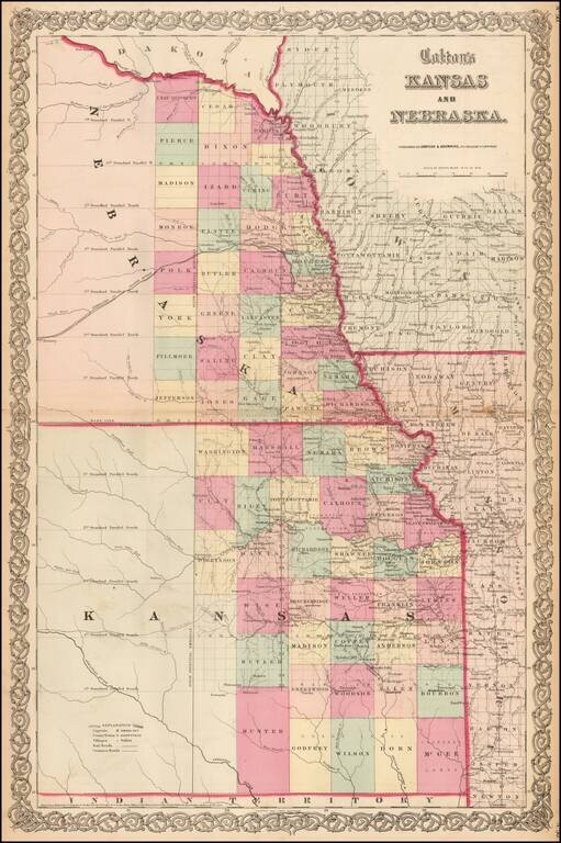
First edition, second state of this rare and important separately issued map of Kansas and Nebraska, published by J.H. Colton in New York. Colton's map is the first printed map to show the configurations of Nebraska and Kansas after the creation of...
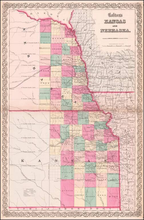
Vibrant example of this early map of Kansas and Nebraska, which was only issued in the vertical format for a few years. Primitive County configurations in the west and south. Multiple proposed railroad routes throughout the map.
Vibrant example of this early map of Kansas and Nebraska, which was only issued in the vertical format for a few years. Primitive County configurations in the west and south. Multiple proposed railroad routes throughout the map.
A cornerstone map, exceptionally detailed and showing many routes and places of interest in the settlement of the American West. This map was published several times from the mid-1850s through the 1870s. This map shows Fremont's 1844 and 1845 routes,...
Striking Gold Rush era map of North America, published by J.H. Colton. The map includes an inset of the Gold Regions of California and a large vignette of Pyramid Lake, in Upper California. The routes to the west and the Oregon Trail are highlighted,...
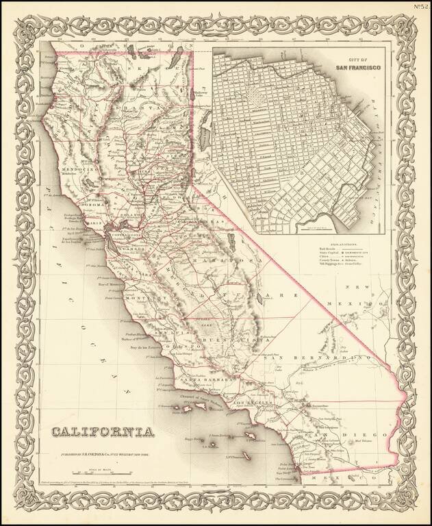
Rare first state of Colton's map of California, from Colton's Atlas of the United States. Only 6 counties in Southern California, including San Diego, Los Angeles, San Bernardino, Buena Vista, Santa Barbara and San Luis Obispo. Decorative border.
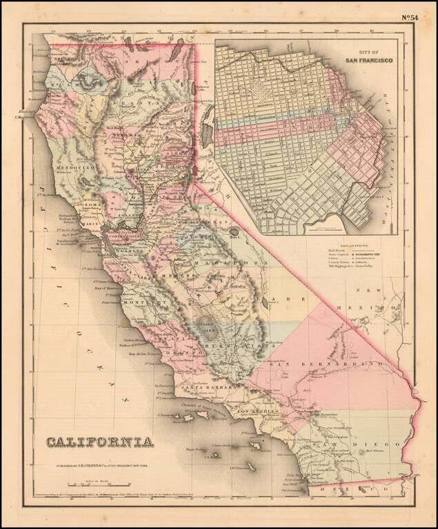
Scarce example of Colton's map of California, from Colton's Atlas of the United States. Hand colored by county. Only 6 counties in Southern California, including San Diego, Los Angeles, San Bernardino, Buena Vista, Santa Barbara and San Luis Obispo....
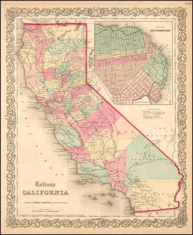
Scarce example of Colton's map of California, from Colton's Atlas of the United States. Hand colored by county. Only 6 counties in Southern California, including San Diego, Los Angeles, San Bernardino, Buena Vista, Santa Barbara and San Luis Obispo....
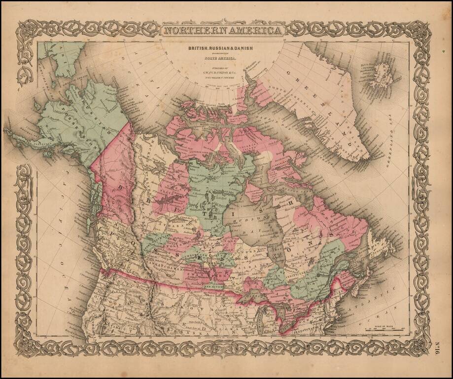
Marvelous map of Canada and Alaska, featuring a host of unusual borders. New Columbia stretches from the US Border to Russian America (Alaska). Lesser Slave Lake, Peace River, Mackenzie's River, Great Slave Lake, Churchill, Athabasca, Nelson, English...
![Hawaiian Group or Sandwich Islands [with] New Zealand [and] Feejee Group, Society Island, Marquesas and Galapagos Islands](/map/small/71009.jpg)
First state (with the strapwork border and "No. 33") of Colton's early map of the Hawaiian Islands, New Zealand, Galapagos, Fiji, Society Islands, and Marquesas. Shows towns, rivers, lakes, mountains, islands, etc. A terrific regional map, from J.H....
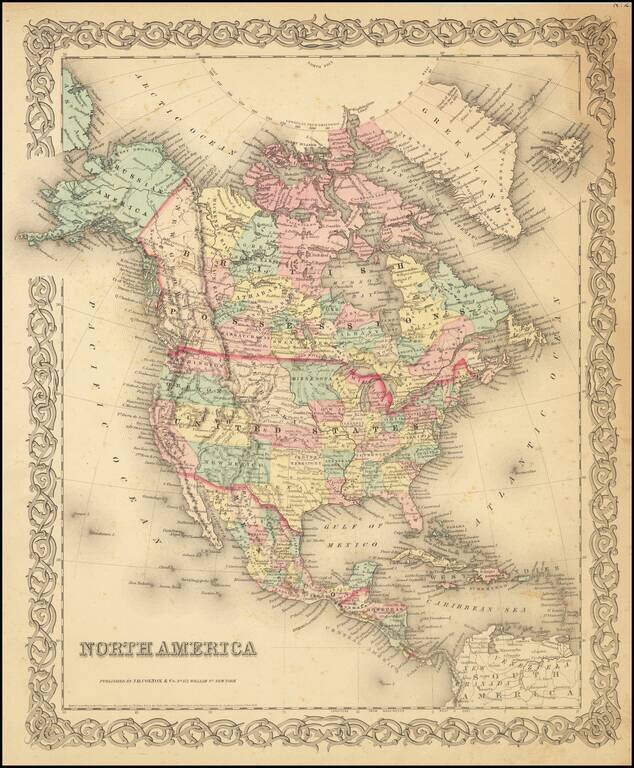
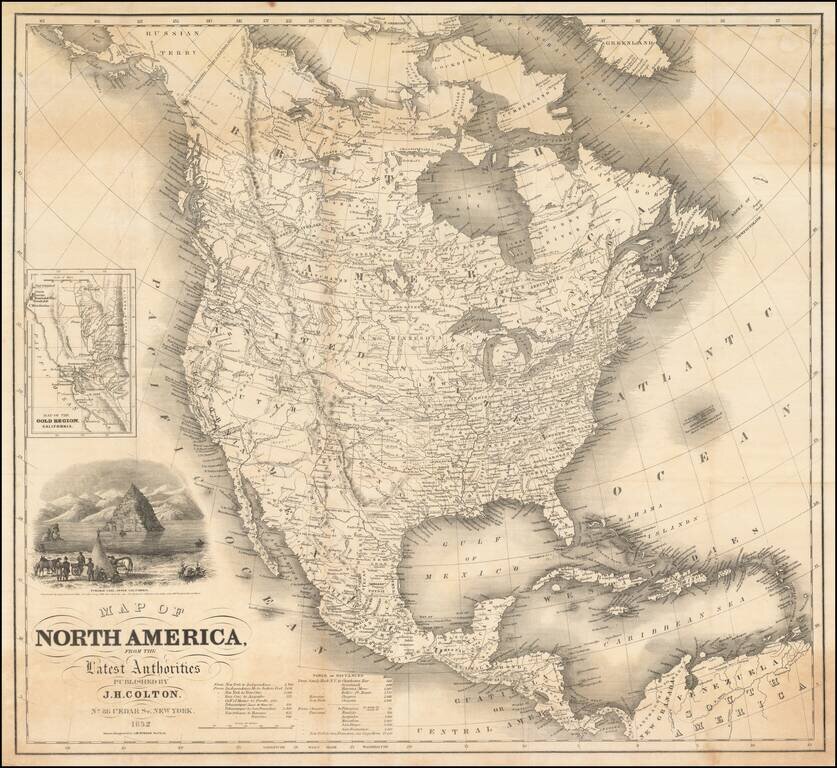
Detailed map of North America, published by JH Colton in New York. The map shows early western territorial configurations, including a massive Nebraska, Kansas running to the Rockies, and only California, Oregon, Washington, Utah and New Mexico west...
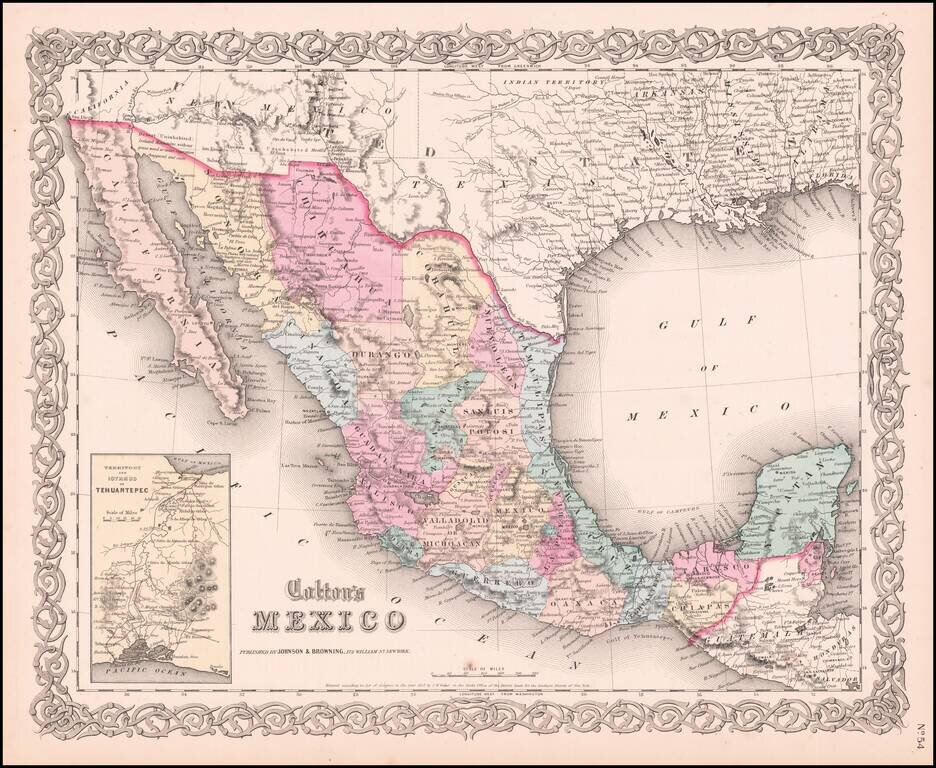
Very detailed map showing towns, counties, Gulf of Mexcico and Gulf of California with lovely decorative border and inset of Territory and Isthmus of Tehuantepec. An excellent pre-Civil War map. From the scarce 1859 edition of Colton's atlas, which is...
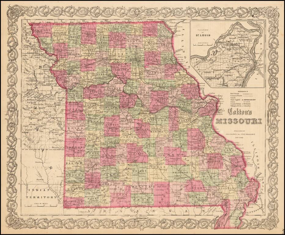
Detailed map of Missouri, colored by counties. Shows roads, railroads, towns, villages, post offices, rivers, lakes, stations and a host of other details. Inset of St. Louis vicinity in upper right corner. Decorative border. A terrific map, from JH...
![Colton's West Indies [Bermuda and Havana insets]](/map/small/67374.jpg)
An 1857 edition of Colton's map of the West Indies which was published nearly yearly from 1855 to 1865 and more occasionally until at least 1874. It is a detailed map of the islands of the Caribbean showing Florida and Central America. The map includes...