G. W. & C. B. Colton was a prominent family firm of mapmakers who were leaders in the American map trade in the nineteenth century. Its founder, Joseph Hutchins Colton (1800-1893), was a Massachusetts native. Colton did not start in the map trade; rather, he worked in a general store from 1816 to 1829 and then as a night clerk at the United States Post Office in Hartford, Connecticut. By 1830, he was in New York City, where he set up his publishing business a year later.
The first printed item with his imprint is dated 1833, a reprint of S. Stiles & Company’s edition of David Burr’s map of the state of New York. He also printed John Disturnell’s map of New York City in 1833. Colton’s next cartographic venture was in 1835, when he acquired the rights to John Farmer’s seminal maps of Michigan and Wisconsin. Another early and important Colton work is his Topographical Map of the City and County of New York and the Adjacent Country (1836). In 1839, Colton began issuing the Western Tourist and Emigrant’s Guide, which was originally issued by J. Calvin Smith.
During this first decade, Colton did not have a resident map engraver; he relied upon copyrights purchased from other map makers, most often S. Stiles & Company, and later Stiles, Sherman & Smith. Smith was a charter member of the American Geographical and Statistical Society, as was John Disturnell. This connection would bear fruit for Colton during the early period in his career, helping him to acquire the rights to several important maps. By 1850, the Colton firm was one of the primary publishers of guidebooks and immigrant and railroad maps, known for the high-quality steel plate engravings with decorative borders and hand watercolors.
In 1846, Colton published Colton’s Map of the United States of America, British Possessions . . . his first venture into the wall map business. This work would be issued until 1884 and was the first of several successful wall maps issued by the firm, including collaborative works with D.G. Johnson. From the 1840s to 1855, the firm focused on the production of railroad maps. Later, it published a number of Civil War maps.
In 1855, Colton finally issued his first atlas, Colton’s Atlas of the World, issued in two volumes in 1855 and 1856. In 1857 the work was reduced to a single volume under the title of Colton’s General Atlas, which was published in largely the same format until 1888. It is in this work that George Woolworth (G. W.) Colton’s name appears for the first time.
Born in 1827 and lacking formal training as a mapmaker, G. W. joined his father’s business and would later help it to thrive. His brother Charles B. (C. B.) Colton would also join the firm. Beginning in 1859, the General Atlas gives credit to Johnson & Browning, a credit which disappears after 1860, when Johnson & Browning launched their own atlas venture, Johnson’s New Illustrated (Steel Plate) Family Atlas, which bears Colton’s name as the publisher in the 1860 and 1861 editions.
J.H. Colton also published a number of smaller atlases and school geographies, including his Atlas of America (1854-56), his Illustrated Cabinet Atlas (1859), Colton’s Condensed Cabinet Atlas of Descriptive Geography (1864) and Colton’s Quarto Atlas of the World (1865). From 1850 to the early 1890s, the firm also published several school atlases and pocket maps. The firm continued until the late 1890s, when it merged with a competitor and then ceased to trade under the name Colton.
![Colton's South Carolina [Charleston Inset]](/map/small/69996.jpg)
Antique map of South Carolina from one of the most prolific American mapmakers of the 19th century. The map shows the routes, railroads, and settlements in the state, though it also locates various other features including rivers, canals, and even...
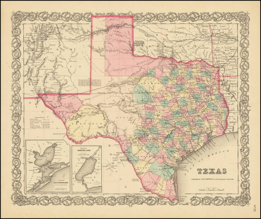
Early State of Colton's Atlas Map of Texas Fine early map of Texas, from Colton's General Atlas, the only edition to appear in a single page format. The map shows a very incomplete set of Western Texas Counties. The German Settlements in Gillespie...
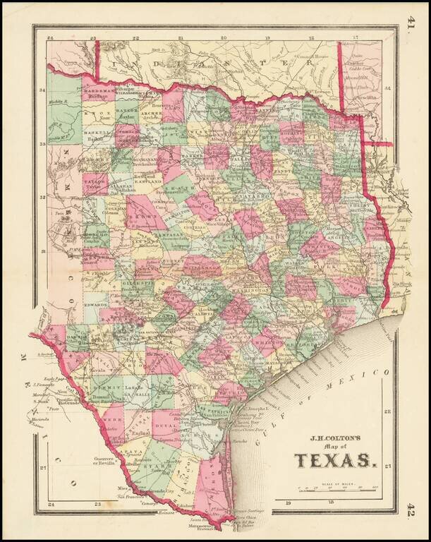
Scarce map of Texas, published at the beginning of the American Civil War. We have dated the map based upon the configuration of Edwards County, which lasted until January 1862.
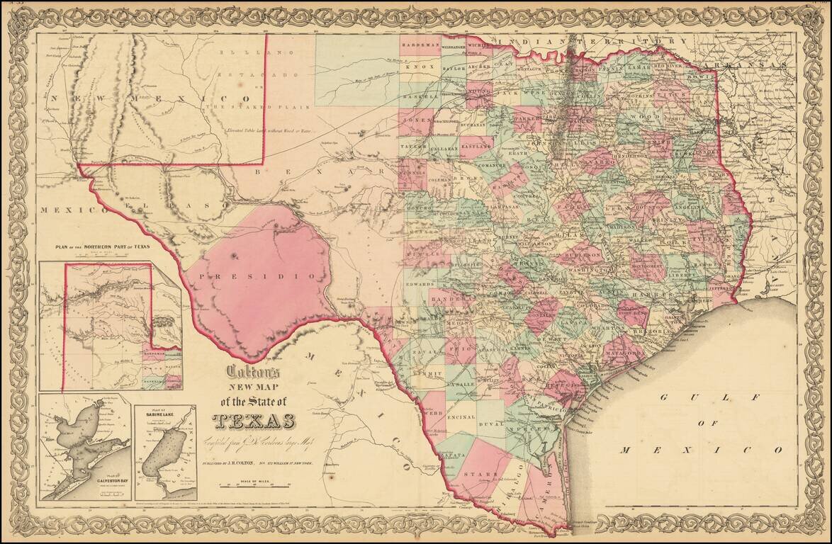
Detailed map of Texas, colored by counties and showing the primitive county configurations in the west. The map is based upon Jacob De Cordova's seminal map of the state, which was first issued in 1849. The map illustrates many early roads, towns,...
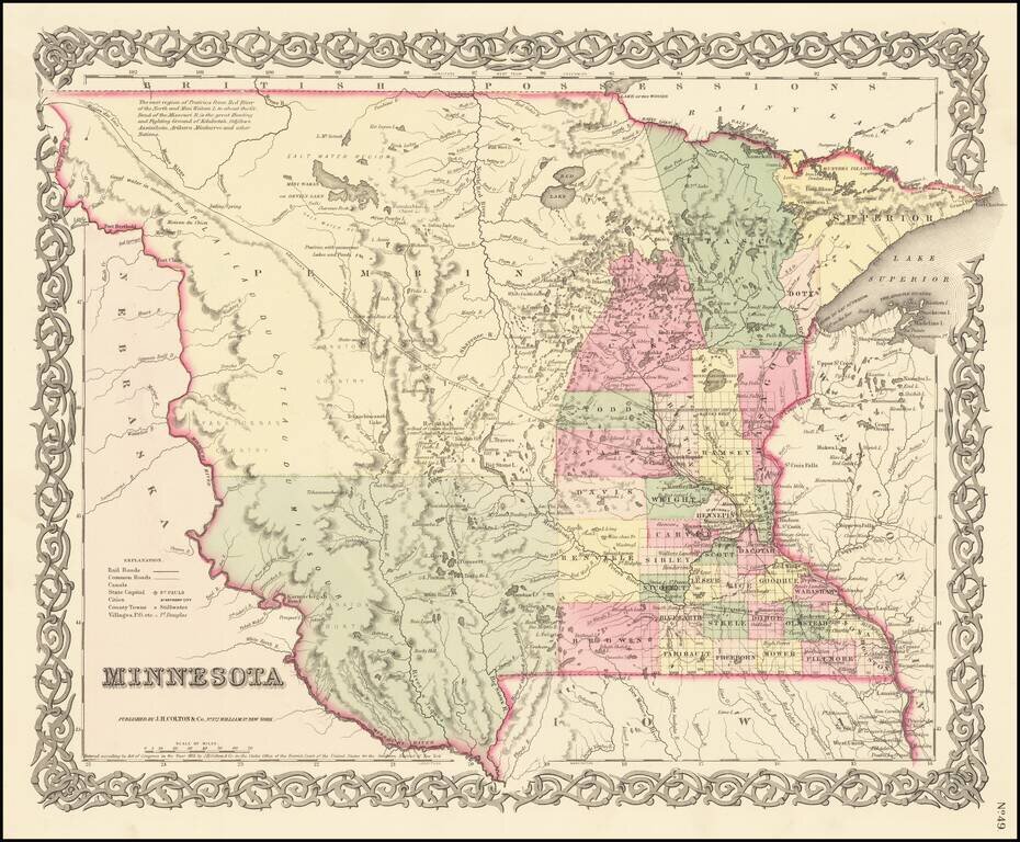
First Atlas State of Colton's Map of Minnesota Territory First atlas state of Colton's Map of Minnesota Territory, which extends to the Missouri River. Massive Pembina County and Yankton County dominate the western 2/3rds of the map. Only a hand...
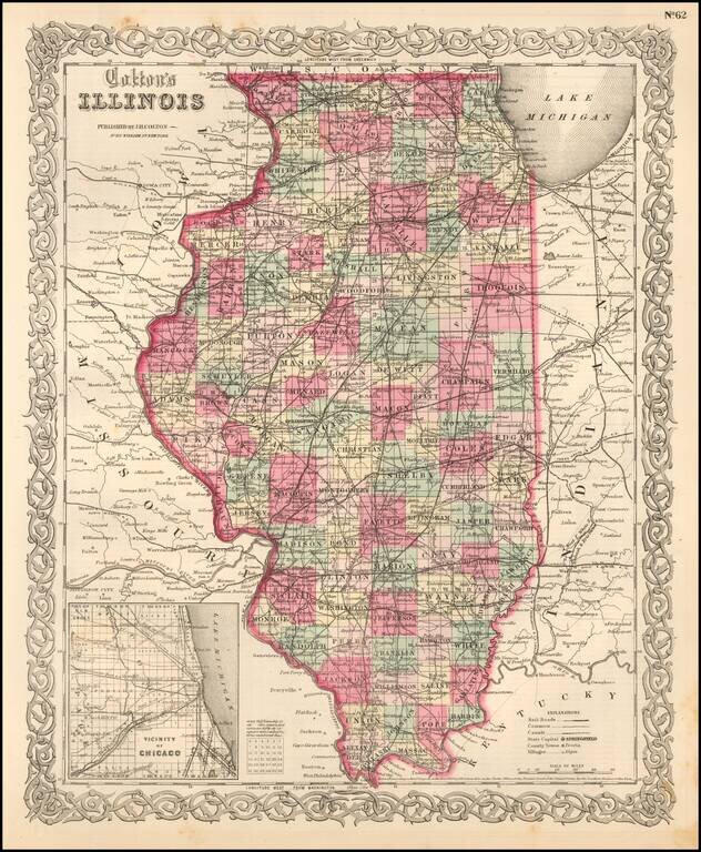
Detailed map of Illinois, colored by counties. The map shows roads, railroads, towns, villages, post offices, canals, rivers, lakes, stations and a host of other details. Inset of Chicago vicinity in lower left corner. Decorative border. A terrific...
![The City of St. Louis [with] The City of Chicago](/map/small/70257.jpg)
Two detailed maps of the cities of Chicago and St. Louis, published by JH Colton in New York. The maps are each colored by ward, and showing streets, rail lines, parks, buildings and other details.
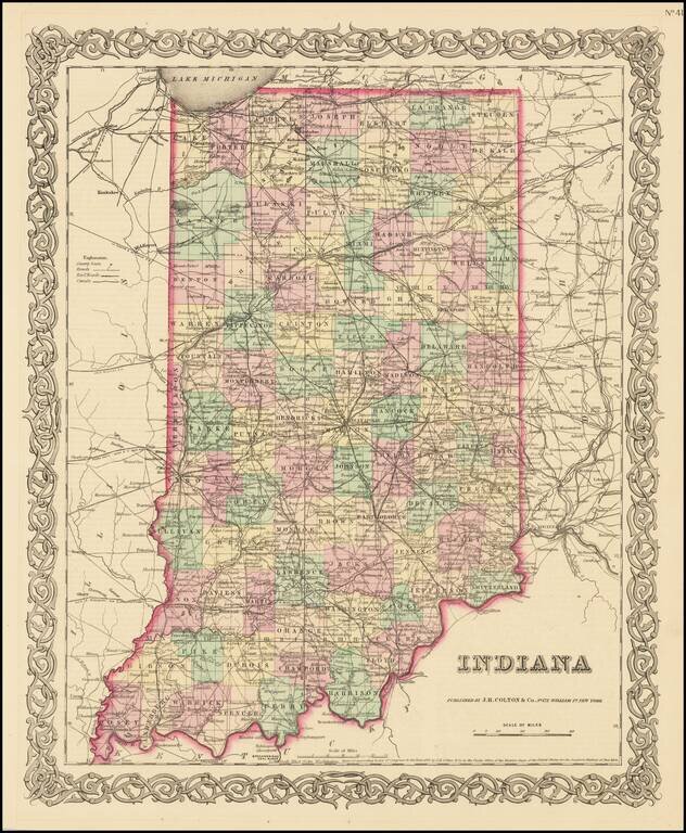
Detailed map of Indiana, published by JH Colton. The map is colored by counties and showing towns, townships, roads, railroads, canals, post offices, rivers, lakes, etc. From the first edition of JH Colton's New General Atlas. JH Colton was one of...
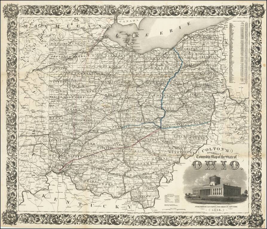
First Edition! Detailed engraved folding map of Ohio, issued by J.H. Colton in 1852. The map shows the "new" Ohio Statehouse building. Ohio had planned to build a new statehouse building for years, but the project took on urgency in 1852 when the old...
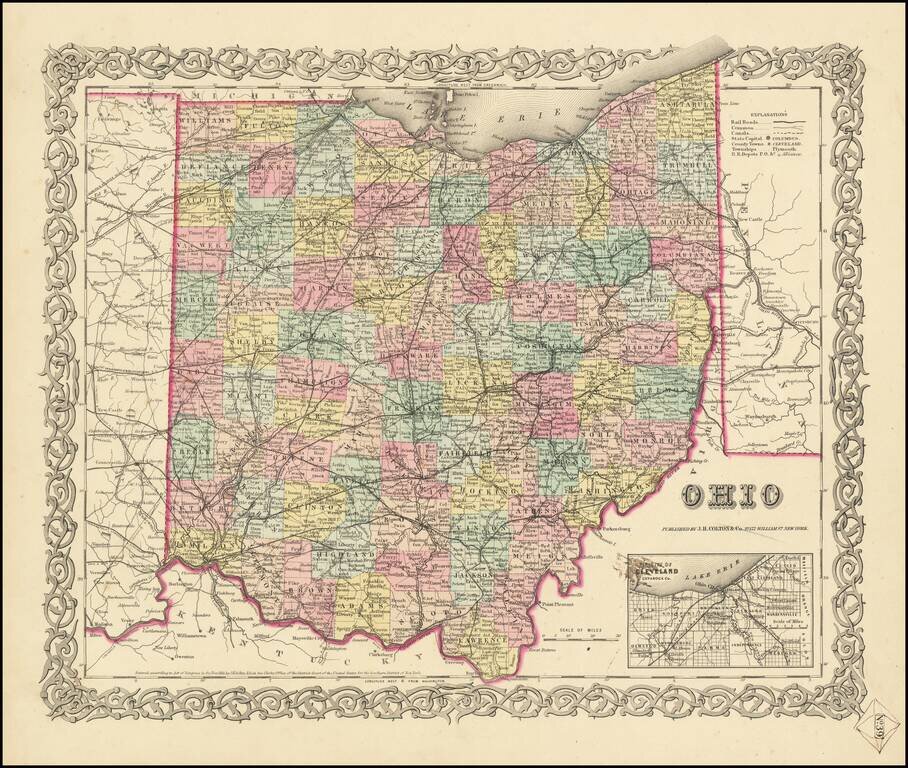
First Edition of JH Colton's Map of Ohio Detailed map of Ohio, published in New York by J.H. Colton. The map is colored by counties, and shows roads, railroads, towns, villages, post offices, canals, rivers, lakes, stations and a host of other...
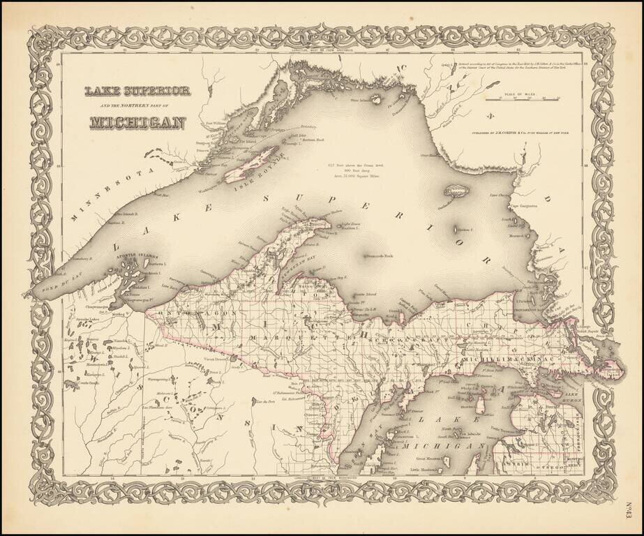
Rare outline color example (first state) of Colton's map of Lake Superior and the Upper Peninsula. Detailed map of the region, showing towns, townships, rivers, lakes, etc. Still no railroad service. JH Colton was one of the pre-eminent American map...
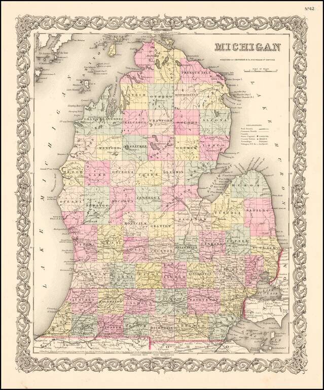
Flawless example of Colton's map of Michigan, colored by county, showing towns, roads, railroads, lakes, rivers, etc. Beautiful decorative border.
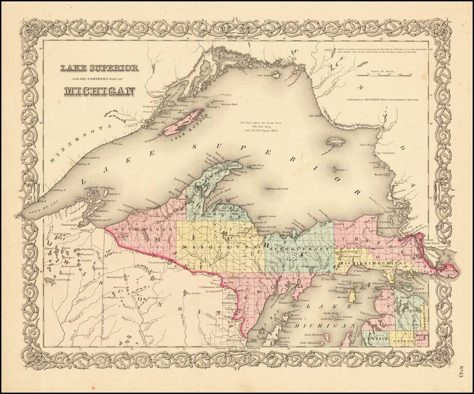
Detailed map of the region, colored by counties and showing towns, townships, rivers, lakes, etc. Still no railroad service. JH Colton was one of the pre-eminent American map publishing firms in the mid-19th Century.
![The Minnesota Handbook, for 1856-7 [with] Minnesota Published by J.H. Colton & Co... 1857.](/map/small/68854.jpg)
1857 Edition of Parker's Handbook to Minnesota, along with the Special Edition of Colton's Map, with "Corrections Furnished by N.H. Parker." This Example from the James J. Hill Library. First and only edition of Parker's important early treatment of...
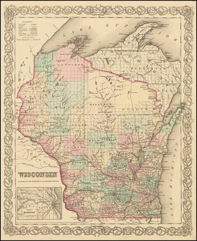
Detailed map of Wisconsin, colored by Counties, with massive Oconto, Marathon, La Point, Douglas, Polk, Burnett and Chippewa counties dominating the north. Inset of Milwaukee. Shows towns, townships, lakes, rivers, post offices, etc. JH Colton was one...
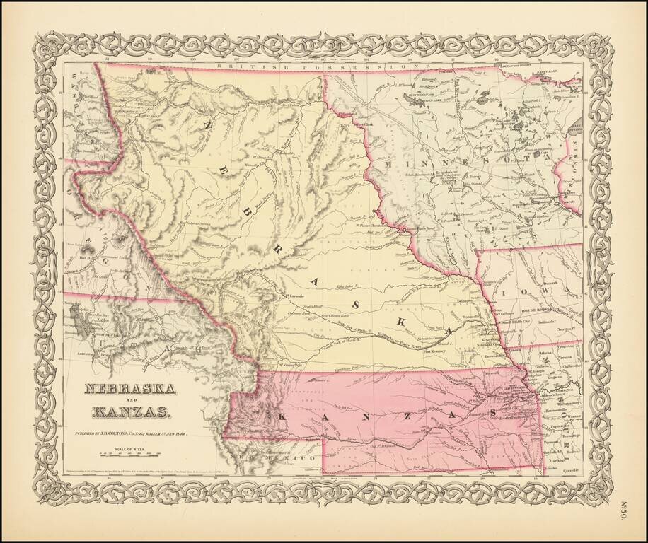
First State of Colton's Map of Kanzas and Nebraska Colton's highly sought after regional map of Nebraska and Kanzas, first published in 1855. Nebraska extends to Canada and the Rockies, taking up large portions of Montana, Wyoming and Utah. Kanzas...