The Dépôt de la Marine, known more formally as the Dépôt des cartes et plans de la Marine, was the central charting institution of France. The centralization of hydrography in France began in earnest when Jean-Baptiste Colbert became First Minister of France in 1661. Under his watch, the first Royal School of Hydrography began operating, as did the first survey of France’s coasts (1670-1689). In 1680, Colbert consolidated various collections of charts and memoirs into a single assemblage, forming the core of sources for what would become the Dépôt.
The Dépôt itself began as the central deposit of charts for the French Navy. In 1720, the Navy consolidated its collection with those government materials covering the colonies, creating a single large repository of navigation. By 1737, the Dépôt was creating its own original charts and, from 1750, they participated in scientific expeditions to determine the accurate calculation of longitude.
In 1773, the Dépôt received a monopoly over the composition, production, and distribution of navigational materials, solidifying their place as the main producer of geographic knowledge in France. Dépôt-approved charts were distributed to official warehouses in port cities and sold by authorized merchants. The charts were of the highest quality, as many of France’s premier mapmakers worked at the Dépôt in the eighteenth century, including Philippe Bauche, Jacques-Nicolas Bellin, Rigobert Bonne, Jean Nicolas Buache, and Charles-François Beautemps-Beaupré.
The Dépôt continued to operate until 1886, when it became the Naval Hydrographic Service. In 1971, it changed names again, this time to the Naval and Oceanographic Service (SHOM). Although its name has changed, its purpose is largely the same, to provide high quality cartographic and scientific information to the France’s Navy and merchant marine.
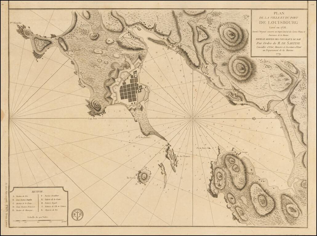
Plan of Louisbourg in 1779 Detailed plan of the town and port of Louisbourg, oriented with west at the top, made by order of the French Depot de la Marine, during the American Revolution. The plan was originally made 2 years prior to the Siege of...
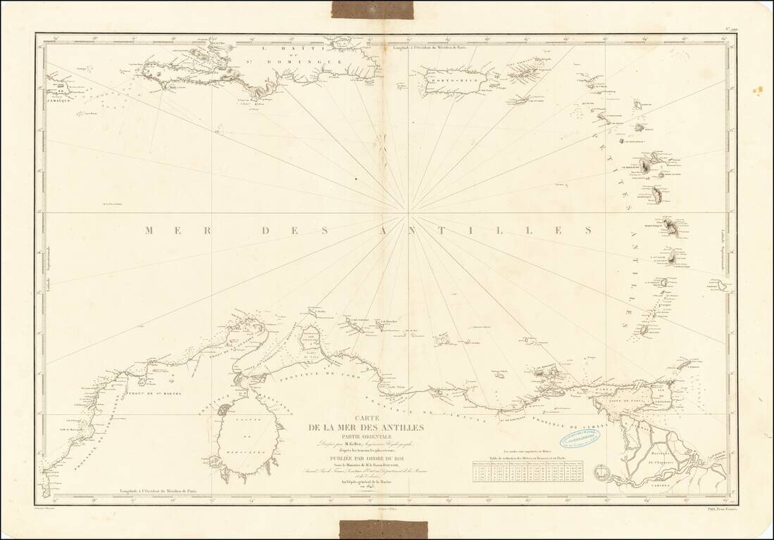
Chart of the Caribbean Used By French Navigator Nice example of the general Depot de la Marine sea chart of the Caribbean and coast of Venezuela, published in 1843. The chart extends from Jamaica and Santa Domingo to the Lesser Antilles, with Puerto...
![[Galapagos] Carte de la Cote Occidentale D'Amerique Comprise Entre Le Golfe de Tehuantepec et le Golfe de Guayaquil (Amerique Centrale, Nlle Grenade, Equateru) . . . .1864](/map/small/57942.jpg)
Scarce sea chart of Central America and the coasts of Colombia, Equador and Peru, published by the French Hydrographical Office. Includes a relatively large treatment of the Galapagos Islands, just five years after Charles Darwin's publication of his...
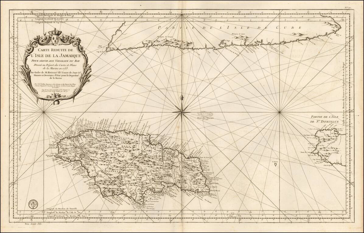
Detailed Depot De La Marine's sea chart of the region centered on Jamaica, with the southern part of Cuba and western end of Hispaniola. This detailed map of Jamaica, shown divided into parishes, includes strong topographical details with many...
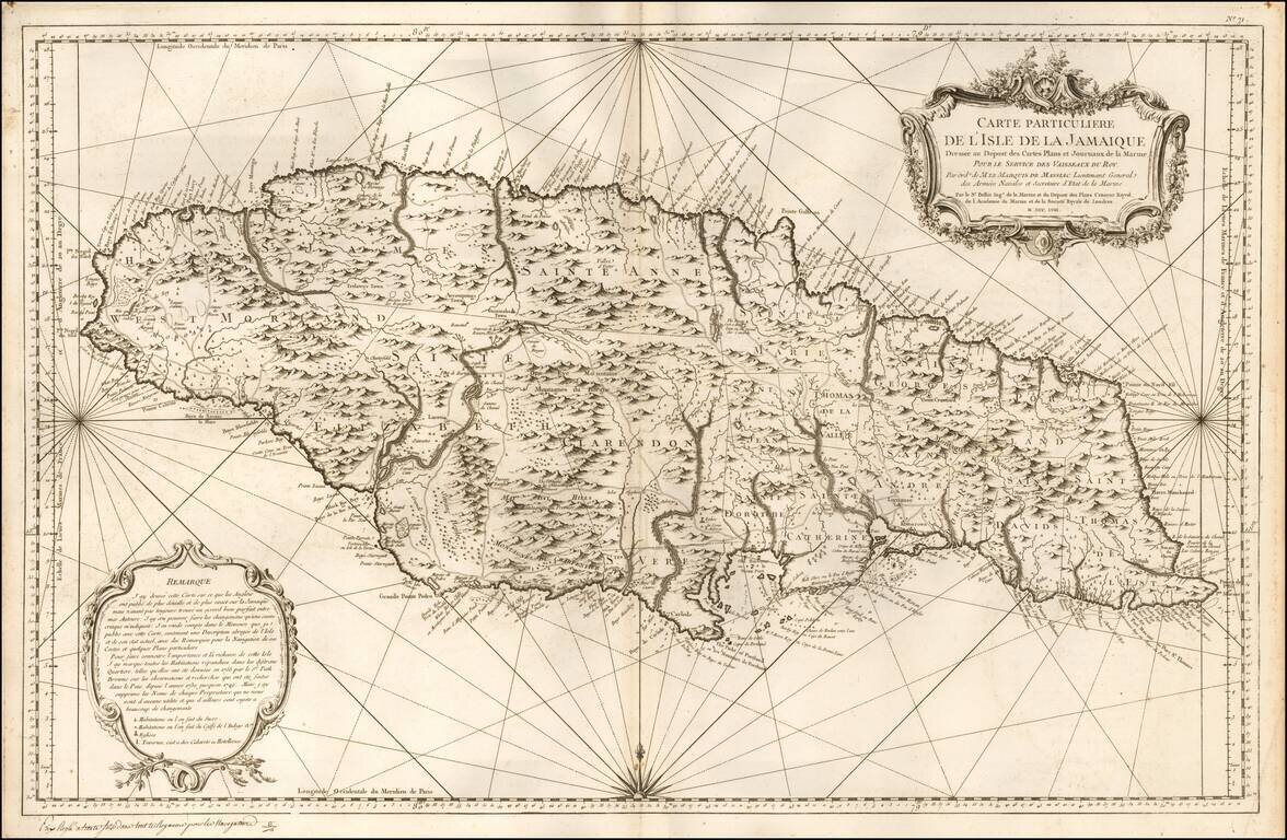
Locates Caberets and Taverns! Detailed Depot De La Marine's sea chart of Jamaica, first published in 1758. This detailed sea chart of Jamaica, shown divided into parishes, includes strong topographical details with many coastal toponyms. Sugar...
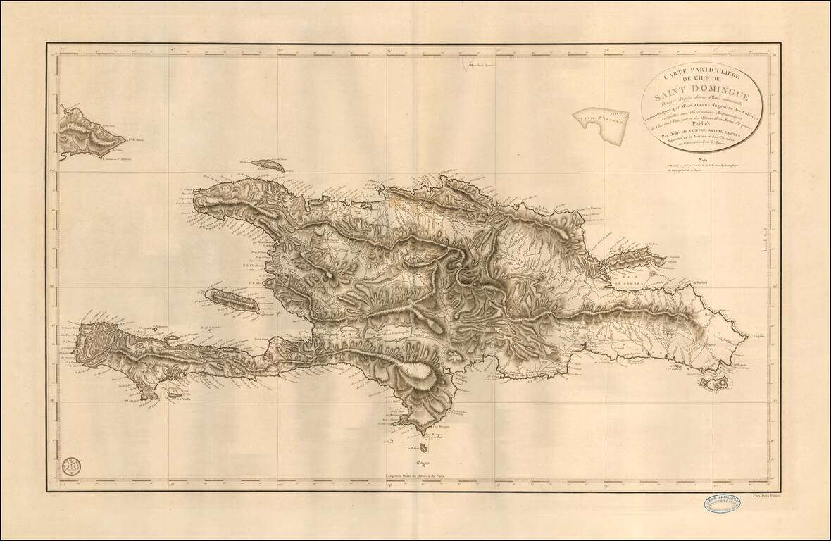
Fine sea chart of Hispaniola, published by the French Depot de la Marine. The map is based upon the work of Antoine-François Sorrel des Revières and Antoine-Hyacinthe-Anne de Chastenet de Puységur. Antoine Sorrel Des Revieres, rose to the...
![Carte Reduite Des Iles Antilles . . . [and] Carte reduite des debouquements de St. Domingue . . . . 1775 [Includes Bahamas]](/map/small/58201.jpg)
A magnificent two-in-one map of the Lesser Antilles (from the eastern tip of Puerto Rico to St. Vincent and Barbados) and of the Turks and Caicos (including part of the Bahamas and the northern coast of Hispaniola). A later reissue and compilation of...
![Canal De La Providence (Bancs De Bahama) . . . 1857 [with] Mouillage De La Point Du Trou Dans Mur (Ile Abaco) . . . [with] Cay Gun (Grand Banc De Bahama)](/map/small/63072.jpg)
Rare set of 3 regional charts of the Bahamas. The largest map shows Little Bahama Bank, Little Abaco, Grand Abaco, Bahama Island, and the region extending southward to New Providence and Andros Island. The Second map shows the southern part of Grand...
Annotated with the notes of a voyage to around the Tierra del Fuego. First state of this scarce French Sea chart of the southernmost part of South America, first published by the Depot de la Marine in 1800. Fine sea chart of the Southernmost coasts...
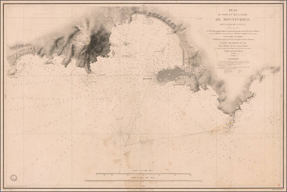
Important Early Sea Chart of the Area around Montevideo, First Surveyed Shortly After Uruguayan Independence Fine, early sea chart of the area around Montevideo, as surveyed by Cyprien Gabriel Le Bourguignon-Duperré the year after the establishment...
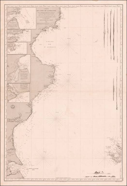
Fine Sea Chart of Eastern Patagonia Based on the Beagle Surveying Expeditions Remarkable sea chart of the eastern coast of Patagonia, published by the French hydrographic authority, the Dépôt de la Marine. The hydrography is based on the pioneering...
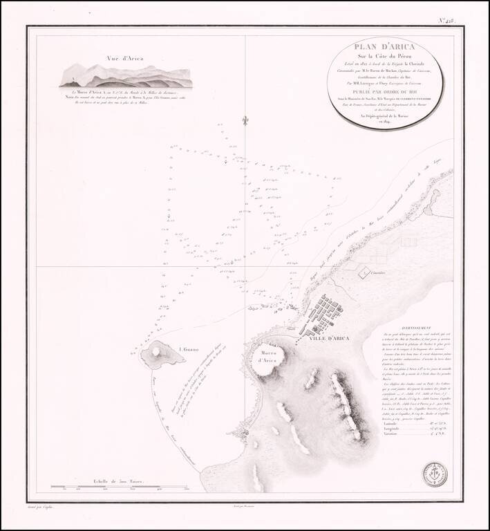
Rare separately published sea chart of the northern Chilean Coastline, centered on the town of Arica. Fine chart of the area around Arica in Chile, on the border with Peru, from Volume 7 of the Neptune Francois. The plan was drawn in 1822 during...
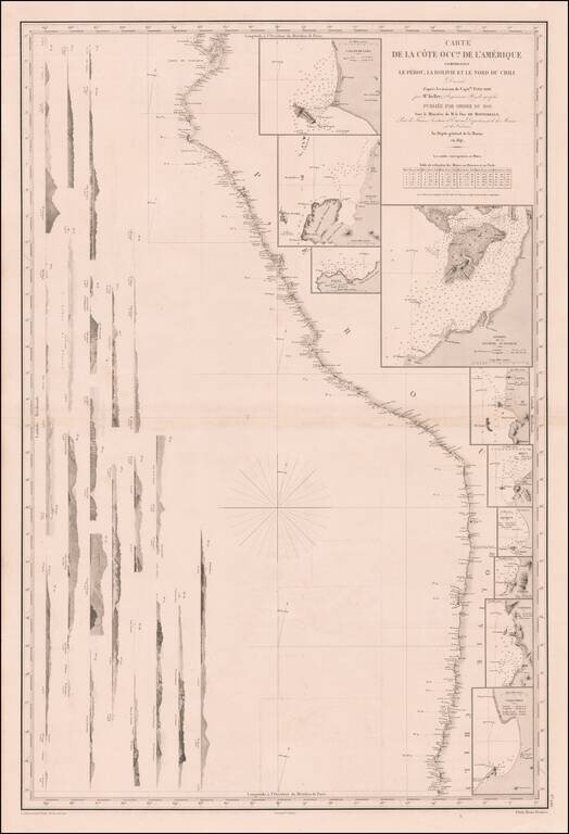
Remarkable sea chart of part of the West coast of South America, published by the French Hydrographic Survey. The chart extends from Guayaquil in the North to the Bay of Coquimbo in Chile, centered on Arica. The map includes large insets plans of:...
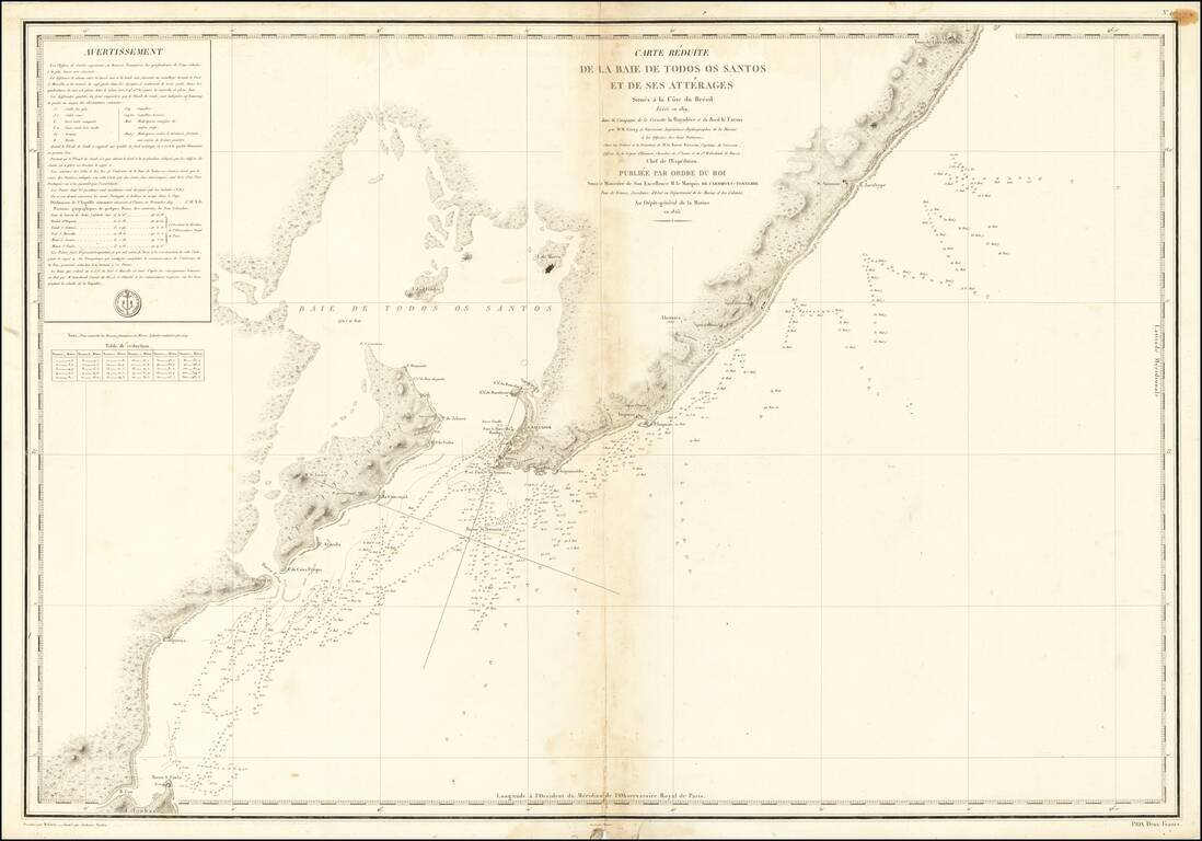
Finely executed sea chart of the area around San Salvador and the Bahia de los Todos Santos (All Saints Bay) in Northern Brazil, published by the French Depot de la Marine. Surveyed in 1819, the map includes significant sailing directions and fine...
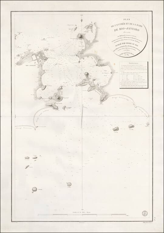
Rare French plan of the Harbor of Rio De Janeiro, engraved by Caplin and drafted by Besancon for the Depot General de La Marine in 1829. The plan is based upon the surveys of Jean Augustine Barral in 1826 and shows the entrance to the Rio de...
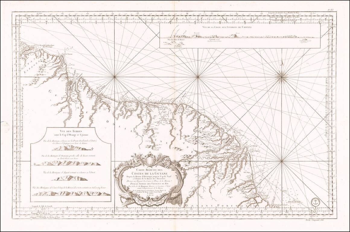
Antique Sea Chart of the Coast of Guyana, French Guiana, Suriname and the Brazilian State of Amapa Finely executed French sea chart of a portion of the northeast Coast of South America, from the mouth of the Orinoco River to the mouth of the Amazon...