Map size in jpg-format: 568858B
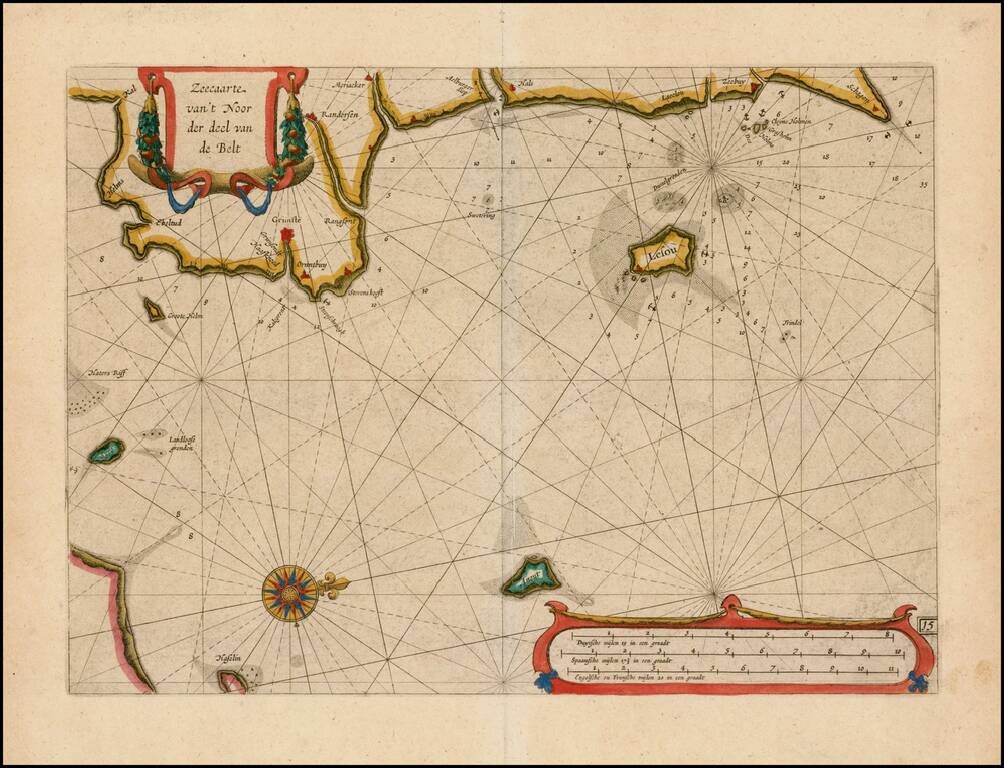
Fine example of this rare sea chart of the east coast of Jutland, published by Blaeu in his Zeespiegel, first published in 1623.
The Zeespiegel was the second of Blaeu's sea atlas, following after his Het Licht der Zee-Vaert, which was first issued in 1607. The Licht was modeled after this work and resembles Waghenaer's Thresoor der Zeevaert, which had the same oblong format with charts intended for professional seafarers. Blaeu's Licht was published in three parts, the first containing sea charts of the area around the Netherlands, England, France and Spain. The second issue concerned the charts of Northern England, Scotland and Scandinavia. Part 3 included charts of the Mediterranean.
Following the expiration of Blaeu's copyright on the Licht, Johannes Jansson produced a sustantially similar work in 1620. In response, Blaeu produced the Zeespiegel, employing an entirely new portable format and abandoning the oblong style of his early Licht.
The present chart is oriented with west at the top and includes the east coast of Jutland.
Willem Janszoon Blaeu (1571-1638) was a prominent Dutch geographer and publisher. Born the son of a herring merchant, Blaeu chose not fish but mathematics and astronomy for his focus. He studied with the famous Danish astronomer Tycho Brahe, with whom he honed his instrument and globe making skills. Blaeu set up shop in Amsterdam, where he sold instruments and globes, published maps, and edited the works of intellectuals like Descartes and Hugo Grotius. In 1635, he released his atlas, Theatrum Orbis Terrarum, sive, Atlas novus.
Willem died in 1638. He had two sons, Cornelis (1610-1648) and Joan (1596-1673). Joan trained as a lawyer, but joined his father’s business rather than practice. After his father’s death, the brothers took over their father’s shop and Joan took on his work as hydrographer to the Dutch East India Company. Later in life, Joan would modify and greatly expand his father’s Atlas novus, eventually releasing his masterpiece, the Atlas maior, between 1662 and 1672.
If you are a student, write to us in telegram: @antiquemaps and indicate what material you need and for what work you need a map in high detail. We are ready to provide material on special terms. For students only!