Map size in jpg-format: 98.5904MiB
Click to open in high resolution (open in new tab).
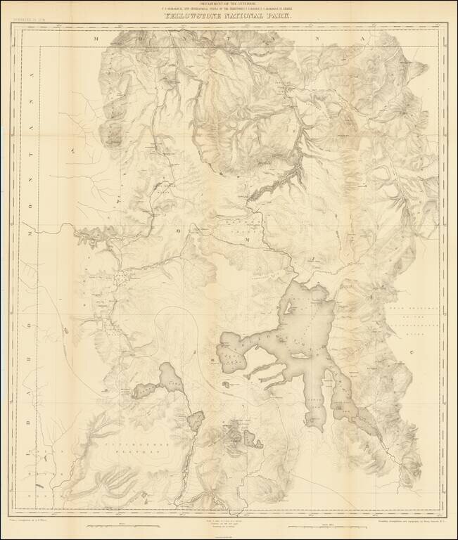
Second Hayden Survey Map of Yellowstone National Park
A nice example of this fine large map of Yellowstone, prepared by the Department of the Interior. The map was prepared in connection with the second survey of the park by Ferdinand V. Hayden, the first coming in 1872. This is one of the earliest maps to show Yellowstone as a national park.
The map shows the entire park from the Montana state line south to well beyond Yellowstone, Shoshone, Lewis and Heart Lakes, and from the border with Idaho east to the Yellowstone Range and the east fork of the Yellowstone River. Terrific detail of topography is included with contour intervals at 100 feet, watershed, and numerous other features, all at a scale of 1 inch to 2 miles. Names the Upper, Shoshone, Gibbon, and Heart Lake Geyser Basins, Mud Geysers, Mammoth Hot Springs, and much more.
The primary triangulation was undertaken by A.D. Wilson, with a secondary triangulation and topography by Henry Gannett, M.E, under the direction of F.V. Hayden.
This 1878 survey also produced a "Preliminary Geological Map of the Yellowstone National Park," the first detailed geological map of the park. Hayden was a particularly important early geologic cartographer in the American west, with a place alongside Clarence King and Joseph LeConte.
Hayden Surveys in Yellowstone
The Hayden Geological Survey of 1871 explored the region of northwestern Wyoming that became Yellowstone National Park in 1872. It was led by geologist Ferdinand Vandeveer Hayden. In the spring of 1871, Hayden selected the members of the survey team, 32 in all, from among friends and colleagues seven previous survey participants and a few political patrons. Included in the party was William Henry Jackson, his photographer from his 1870 survey and Thomas Moran, a guest artist arranged by railroad financier Jay Cooke.
The survey was America's first federally funded geological survey into the Yellowstone region of northwestern Wyoming, given directions by President Ulysses S. Grant's Secretary of Interior Columbus Delano. The following year, Hayden and his work, Preliminary Report of the United States Geological Survey of Montana and Portions of Adjacent Territories; Being a Fifth Annual Report of Progress was instrumental in convincing Congress to establish Yellowstone as the first U.S. National Park, aided by Jackson's stunning large-format photographs and Moran's dramatic paintings.
Yellowstone National Park: The Early Days
The area around the Yellowstone was only first properly explored by white Americans during the Cook-Folsom-Peterson Expedition of 1869. They reported seeing wonders that fascinated people back east. Ferdinand V Hayden was sent by the government to explore the area properly in 1871.
The movement to create parks set aside for public enjoyment started in California, with work by John Muir and contemporaries to preserve Yosemite, Sequoia, and Kings Canyon. These were all made state parks. The movement to do something similar in Yellowstone started almost as soon as the first reports came back. The park was established in 1872, but due to lack of a state government, it was under the federal umbrella, thus a national park.
Poaching was a major issue during the first years of the park, and would only be resolved by the arrival of the US Army in 1886. The army had made a previous short visit in 1877 while pursuing Chief Joseph's Nez Perce tribe, which had taken several tourists captive.
The popularity of the park would continue to grow over the next hundred years, and it remains one of the best-known American national parks today.
If you are a student, write to us in telegram: @antiquemaps and indicate what material you need and for what work you need a map in high detail. We are ready to provide material on special terms. For students only!