Map size in jpg-format: 25.8668MiB
Click to open in high resolution (open in new tab).
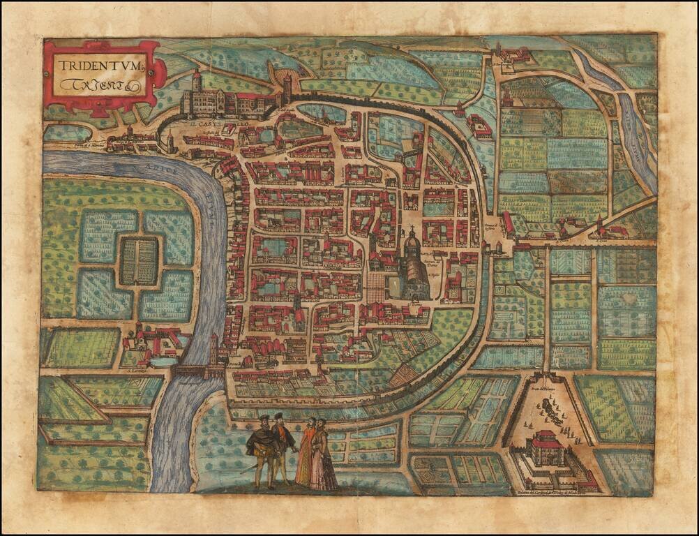
Fine early birdseye view of the Trento in Italy.
From Braun & Hogenberg's Civitatus Orbis Terrarum, the most important book of town plans and views published in the 16th Century.
The bird's-eye plan shows Trento on the Adige with its surrounding fields. On the bend in the river lie the episcopal Castello del Buonconsiglio, with its massive round tower (left) and the Renaissance Magno Palazzo. The dominating Romanesque cathedral in the centre of the plate goes back to the early Christian church of the Holy Sepulchre of St Vigilius. Between the bishop's residence and the cathedral lies the small Gothic church of San Pietro.
Georg Braun (1541-1622) was born and died in Cologne. His primary vocation was as Catholic cleric; he spent thirty-seven years as canon and dean at the church St. Maria ad Gradus, in Cologne. Braun was the chief editor of the Civitates orbis terrarum, the greatest book of town views ever published. His job entailed hiring artists, acquiring source material for the maps and views, and writing the text. In this role, he was assisted by Abraham Ortelius. Braun lived into his 80s, and he was the only member of the original team to witness the publication of the sixth volume in 1617.
If you are a student, write to us in telegram: @antiquemaps and indicate what material you need and for what work you need a map in high detail. We are ready to provide material on special terms. For students only!
![Genua Ligurum domina . . . [and] Florentia urbs est Insignis Hetruariae, olim Fluentia dicta . . . (Genoa & Florence)](/map/small/67437.jpg)