Map size in jpg-format: 50.0975MiB
Click to open in high resolution (open in new tab).
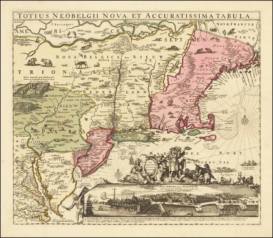
Striking example of Reiner & Josua Ottens edition of Hugo Allard's rare map of New England and the Northeastern United States, including the so-called "Resitutio View" of Manhattan.
Ottens map faithfully follows the cartographic details of the Jansson-Visscher map of the region, which provided a significant improvement over other maps of the region.
In 1655, Nicholas Visscher utilized Jan Jansson's map, with its vignettes of animals and Indian life, and added a view of New Amsterdam, showing the Battery and Dutch buildings on the waterfront. An extensive study of the map by Stokes suggests that the view was drawn sometime between 1653 and 1655, prior to the construction of New York's wall. The first edition of the map (1655-56) is extremely rare and known in only a handful of copies, one of which was used to illustrate the boundary dispute between William Penn and Lord Baltimore.
The view of Manhattan was originally drafted by Adriaen van Donck for the Dutch Colonists in New Amsterdam, in order to illustrate the impoverished conditions of the Colony, and a plea for better support and funding. The Dutch would soon thereafter lose the Colony to the English in 1664, but would subsequently recapture the Colony in August 1673.
Following the re-taking of New Amsterdam by the Dutch from the English, the so-called Resitutio View was first substituted for the earlier view in a map by Hugo Allard. For the first time, New Amsterdam is illustrated from the East. The view is intended to show a far more prosperous-looking Dutch Manhattan. The figure on the pedestal is holding a laurel of victory, while the updated glimpse at the southern tip of Manhattan shows a city that has grown significantly, and is a triumphant indication of Dutch pride in its recapture.
The view shows the city from the Brooklyn shore. On the right-hand side is the wall that became Wall Street with its guardhouse and gate. Along the East River quay are three redoubts fortified with cannons. A body of occupying Dutch soldiers can be seen on the quay, and to the left is the canal that cut into the city from the harbor, shown here for the first time in its completed state. At far left is the Reformed Church, and Fort Amsterdam near the Battery, "called James Fort by the English."
There were numerous other changes in addition to the new view. The Dutch fleet under the command of Cornelius Evertson that seized the city is shown off the south coast of Long Island. A key identifying six sites by letter in Manhattan and Long Island has been added to the south of the latter island.
The present example is the final state of the map, bearing the imprint of Reiner & Josua Ottens.
If you are a student, write to us in telegram: @antiquemaps and indicate what material you need and for what work you need a map in high detail. We are ready to provide material on special terms. For students only!
![[The First Maps in a la poupée Printed Color] Cartes en Couleur des Lieux Sujets aux tremblements de Terre Dans toutes les parties du Monde Selon le Sisteme de l’impulsion Solaire](/map/small/52293op.jpg)

