Map size in jpg-format: 20.3655MiB
Click to open in high resolution (open in new tab).
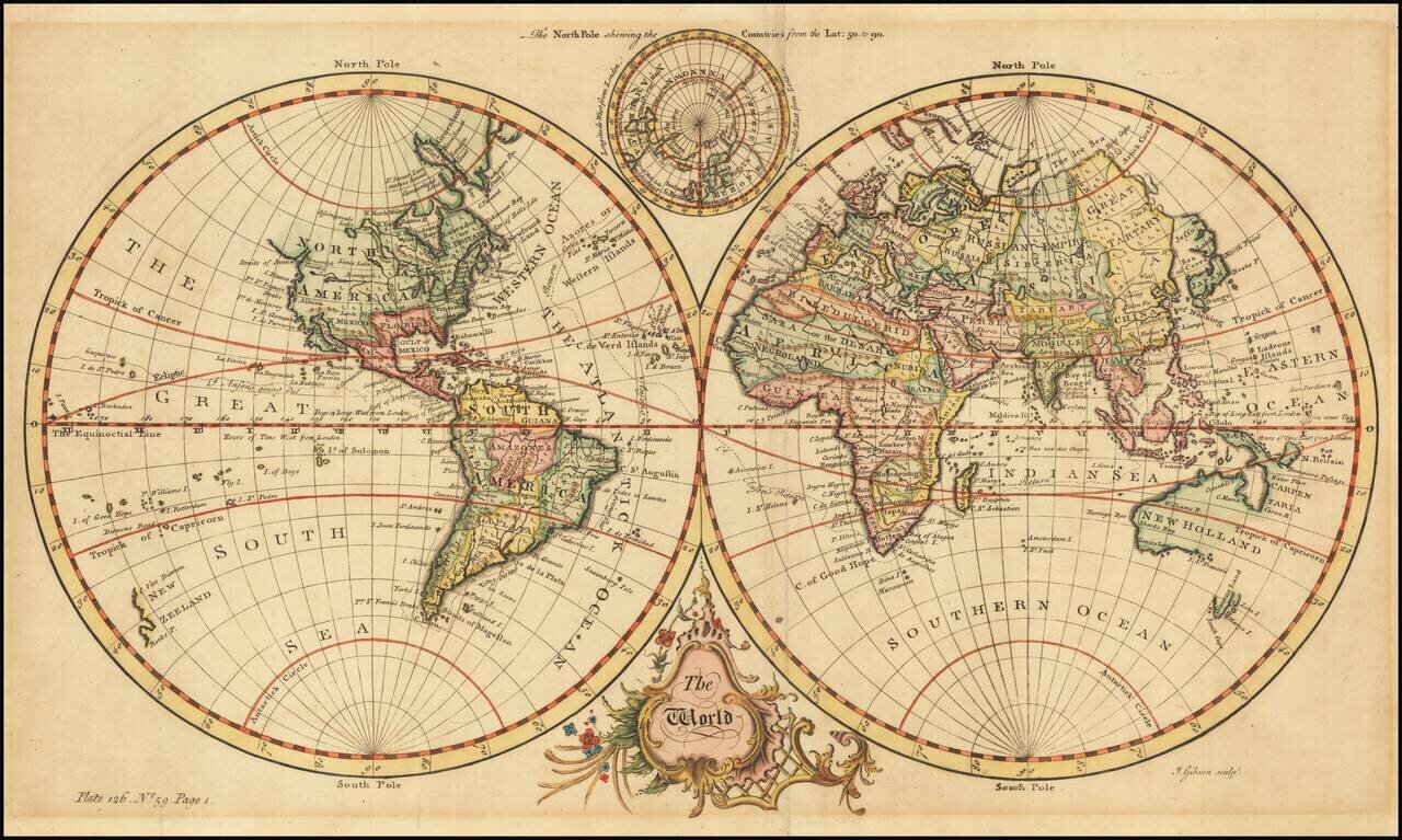
Fine Double-Hemisphere World Map
Elegant world map, from Thomas Salmon’s Universall Traveller, and showing Anson’s circumnavigation track.
The two hemispheres are set in a plain background. At bottom is a Baroque title cartouche. At top, nestled between the larger hemispheres, is a polar hemisphere showing the North Pole. While Greenland, Siberia, and North America all extend toward the pole, no landmasses are shown there; it remains “unknown”, ringed by “The Icy Sea.”
The South Pole is entirely free of landmasses. In the Pacific, the west coast of New Zealand is included, based on Tasman’s voyages in the early 1640s. Northwest, an unfinished coastline suggests more land between America and Asia. The Strait of Anian stretches into the American interior.
In the east, Australia’s outline remains only partial, with toponyms from the seventeenth century voyages of the Dutch (Lewins Land, Hartogs Ree) and the ca. 1700 expedition of William Dampier (Sharks Bay). Australia connects to New Guinea via Carpentaria, a common cartographic convention in the eighteenth century. Nearby is Dampiers Passage and N. Britain, more evidence of the voyages of Dampier, who was the first person to circumnavigate the world three times.
John Gibson, the engraver, was known to publish maps for The Gentleman’s Magazine, The Universal Magazine, The Universal Museum, and others. In the lower left is a plate number, volume number, and page number—instructions to the binder for the correct placement of the illustration within the larger text.
That larger text was volume one of Thomas Salmon’s The universall traveller: or, A compleat description of the several nations of the world (London: Printed for Richard Baldwin, at the Rose in Pater-Noster Row, 1752-3).
Anson’s circumnavigation (1740-44) and voyage account
In 1739, resentment over Spanish raids of British ships in the Caribbean sparked the War of Jenkin’s Ear, which would widen into the larger War of Austrian Succession. The Commissioners of the British Admiralty planned a global strategy to harass Spanish trade and weaken its over-stretched navy and merchant marine. Anson’s voyage was part of this strategy. He set out in 1740 with a squadron of six ships and 1,900 men.
By 1743, Anson had crossed the Pacific after raiding the west coast of South America. Prior to crossing he had waited off the Mexican coast for the Acapulco galleon, full of silver, to appear, but he only succeeded in blocking the ship from leaving port. Meanwhile, he had also lost five of his ships and 1,400 of his men, primarily to scurvy; only his own ship, Centurion, remained intact.
After repairing at Macao, Anson let Chinese officials know that he was headed for Britain; in reality, he sailed to the Philippines to await the entrance of the Acapulco galleon. Remarkably, considering the voyage prior to that point, the Centurion took the Nuestra Señora de la Covadonga with only light casualties.
The publication of the Voyage round the World
Anson returned home rich and quickly became famous as well, a bright spot in an otherwise dismal war devoid of triumphant victories. Named a Commissioner of the Admiralty, Anson set about arranging the publication of his experiences in the Pacific. The work was written by the Centurion’s chaplain, Richard Walter, and Benjamin Robins, a Fellow of the Royal Society and a military engineer. It took four years to compile Anson’s and his officer’s papers and a Voyage round the World finally debuted in May 1748.
The account was immensely popular; it was published in quarto with 42 plates, while a simultaneously published octavo edition, with only three plates also flooded book sellers’ shops. The charts for the account, three in all, were engraved by Richard William Seale. Among other clients, he engraved for the Universal Spectator, in which the Anson expedition was serialized after it returned in 1744.
The Anson account was one of the bestsellers of the eighteenth century; it appeared in at least sixteen editions in the eighteenth century alone. It was also published in several languages, including Dutch, French, German, Russian, Italian, and Swedish.
Strait of Anian
This strait, believed to separate northwestern America from northeastern Asia, was related to the centuries-long quest to find a Northwest Passage connecting the Atlantic Ocean to the Pacific. Appearing on maps beginning in the mid- to late-fourteenth century, the rumor of this strait and a Northwest Passage in general inspired many voyages of discovery, including those of John Cabot, Sir Francis Drake, Gaspar Corte-Real, Jacques Cartier, and Sir Humphrey Gilbert.
The term Anian itself comes from Marco Polo’s thirteenth-century accounts of his travels. Polo used the term to refer to the Gulf of Tonkin, but cartographers thought it could refer to this supposed strait between Asia and North America. The Strait of Anian, so named, first appeared in a 1562 map by Giacomo Gastaldi, and was later adopted by Bolognini Zaltieri and Gerardus Mercator.
If you are a student, write to us in telegram: @antiquemaps and indicate what material you need and for what work you need a map in high detail. We are ready to provide material on special terms. For students only!


