logo

1685. The Empire of Germany in which are distinguished the Dominions of the House of Austria... | The Empire of Germany divided according to the Extent of all the Estates Principalities and Soveraignities that are or have been comprehended under the name of Ger

  • The Empire of Germany in which are distinguished the Dominions of the House of Austria... | The Empire of Germany divided according to the Extent of all the Estates Principalities and Soveraignities that are or have been comprehended under the name of Ger

The Empire of Germany in which are distinguished the Dominions of the House of Austria... | The Empire of Germany divided according to the Extent of all the Estates Principalities and Soveraignities that are or have been comprehended under the name of Ger information:

Year of creation: 
Resolution size (pixels): 
 21319x13993 px
Disk Size: 
 103.575MiB
Number of pages: 
 1
Place: 
 London
Author: 

Print information. Print size (Width x height in inches):
Printing at 72 dpi 
  296.1 х 194.35
Printing at 150 dpi 
 142.13 х 93.29
Printing at 300 dpi 
 71.06 х 46.64

An example of detailing the file of this map of in a printable high-resolution:

Click to open in high resolution (open in new tab).
Attention! this is just the central piece (central area 960x960 px) of the map file!
This is an example, so that you can see and study the level of detail of a given map. The entire Map will be fully available after payment!

The Empire of Germany in which are distinguished the Dominions of the House of Austria... | The Empire of Germany divided according to the Extent of all the Estates Principalities and Soveraignities that are or have been comprehended under the name of Ger

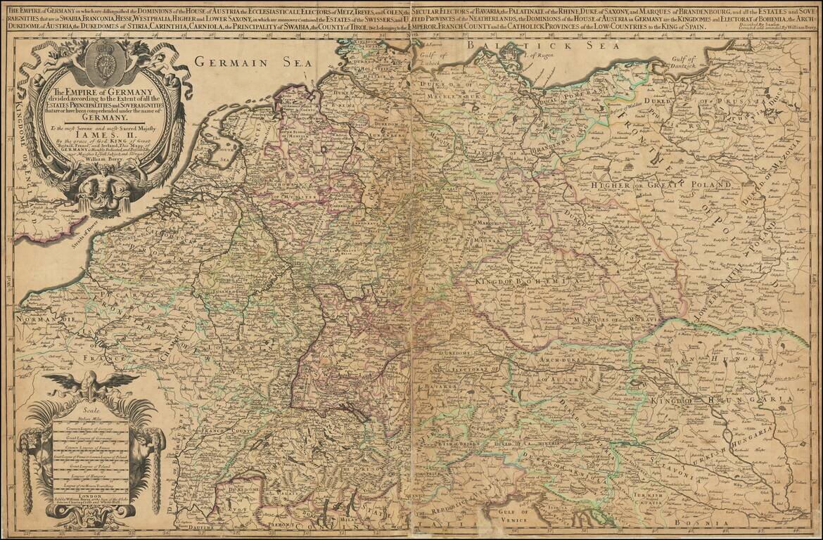
First State of Berry's Rare Map of Germany.

Large-format engraved map of Germany, extending to Poland and the Low Countries, by one of London's premier 17th-century mapmakers, William Berry.

Many of Berry's maps are dedicated to Charles II, however, this one was dedicated to James II who took the throne in 1685, which he held until the Glorious Revolution in 1688.

Berry's composite atlases are sometimes referred to as English Sanson atlases. In this case, his map of Africa is closely based on the 1674 Jaillot Africa (Betz 118), which in turn was based on the Guillaume Sanson Africa of 1668. Berry credits Sanson in the title.

This is the 1685 first state, with William Berry's imprint. The map was issued again in 1743.


Special conditions for students!

If you are a student, write to us in telegram: @antiquemaps and indicate what material you need and for what work you need a map in high detail. We are ready to provide material on special terms. For students only!

Item information:

Year of creation:
Size:
21319x13993 px
Disk:
103.575MiB
Number of pages:
1
Place:
London
Author:
William Berry.
$21.99

Related item