Map size in jpg-format: 21.255MiB
Click to open in high resolution (open in new tab).
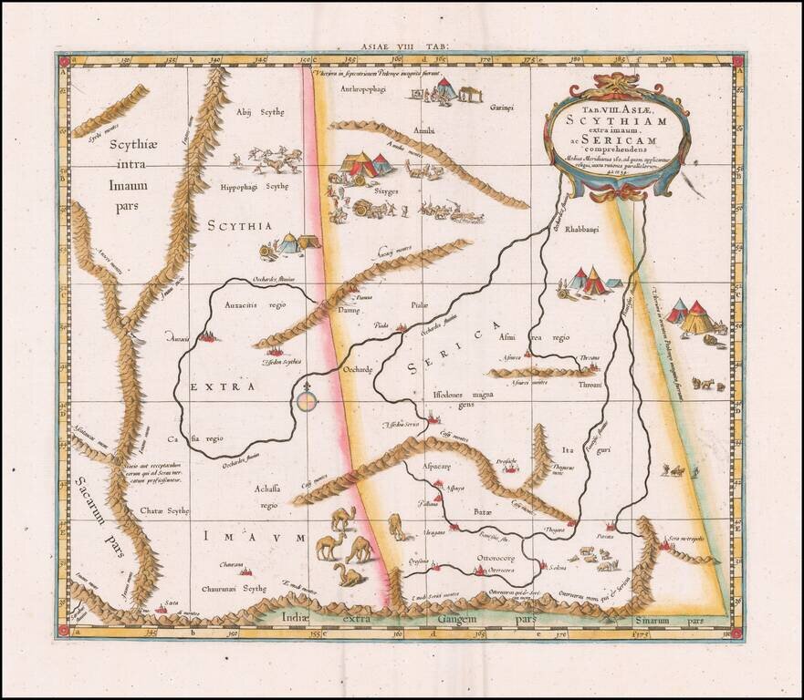
Fine Ptolemaic Map of Central Asia from Mercator’s Geographia
Finely engraved map of Central Asia east of the Caspian Sea, encompassing parts of present-day Pakistan, Tajikistan, Kyrgyzstan, and western China. The map is from Mercator’s highly regarded version of Ptolemy’s Geographia.
The present map focuses on the regions of Scythia and Serica, and is bounded by the Himalayas to the south. To ancient Greek and Roman geographers in the time of Ptolemy, Scythia and Serica represented the northern and eastern limits of the known world. In fact, notes at the top and right sides of the map indicate that lands to the north and east of those depicted are unknown. The two regions are separated by a dotted line running vertically through the map.
To the west is the land of the Scythians, a nomadic people speaking an Iranian language who were active from about the ninth century BC to the second century AD. The region corresponds to parts of present-day Pakistan, Tajikistan, and Kyrgyzstan. Scythia features the Imaus mountains, corresponding to the Pamir, extending north from the Himalayas before splitting into two separate ranges. The Auzacii and Casii mountain ranges straddling Scythia and Serica serve as two sources for the Oechardes River, which runs northeast along the map.
To the east is Serica, “the land of silk,” named for the Seres, or silk people. As its name suggests, Serica could be reached overland via the Silk Road. While Serica is often thought to be synonymous with China, Ptolemy in fact differentiated between Serica and Sinae (which is indicated in the southeast corner of the map with the area Sinarum pars). In the present map, Serica is depicted as corresponding to present-day western or northwestern China, encompassing the Uygur Autonomous Region of Xinjiang.
Serica features several mountain ranges, including the Annibi and Auzacii to the north, corresponding to the Altai. The Casii, to the south, may correspond to mountains in the Gobi Desert, and serve as a source, along with the Himalayas, for the Bautisus river running vertically along the eastern border. The Bautisus corresponds to the Yellow, or Huang He River, in China.
The present map also features fascinating illustrative content. The map’s two major rivers, the Oechardes and Bautisus, both end in the north as they reach the title cartouche, which is bordered by an ornamented frame. Throughout the map, illustrated vignettes depict scenes from the lives of the region’s inhabitants. Several vignettes depict nomadic peoples’ daily activities, such as herding or cooking, near their clusters of tents. One scene in the north of Scythia depicts a battle, with figures holding bows and spears. A large vignette in the south of the map at the border of Scythia and Serica depicts a group of one-humped camels. These illustrations add to the map’s depiction of the world in antiquity.
Mercator’s Geographia
The present map was published in Gerard Mercator’s version of Ptolemy’s Geographia, first published in 1578, with editions still issued as late as 1730. While perhaps best known for his world atlas, published in various editions beginning in 1595 for nearly a century, Mercator’s Geographia is highly respected for the depth of research and fine engraving represented in its maps.
By the early sixteenth century, mapmakers such as Martin Waldseemüller and Lorenz Fries, wishing to reconcile Ptolemy’s worldview with updated geographic information, had issued versions of the Geographia divided in two sections—one with the classic Ptolemaic maps and texts, and a second depicting the modern world. In opposition to this trend, Mercator’s twenty-seven newly engraved maps for the Geographia contained no updated information.
In order to avoid misinterpretations of Ptolemy’s work by earlier editors, Mercator desired for his Geographia to accurately portray Ptolemy’s second-century view of the world. He envisioned this representation of the classical world serving as a companion to his forthcoming atlas of the modern world. To achieve this, he spent thirteen years researching, drawing, and engraving the maps he included. The quality he achieved in his engravings was such that the original printing plates were still in use at the time of the last edition of his Geographia in 1730.
Ptolemy’s Geographia in Renaissance Europe
The translation of Claudius Ptolemy’s Geographia from Greek into Latin for the first time in the late fourteenth and early fifteenth centuries spurred a wave of renewed interest and updated editions of his work. Ptolemy’s ideas had been absent from western European intellectual history for roughly a thousand years, although Arab scholars interacted with his ideas from the ninth century onward.
In 1295, a Greek monk found a manuscript of Ptolemy in Constantinople; the emperor ordered a copy made and the Greek text began to circulate in eastern Europe. In 1393, a Byzantine diplomat brought a copy of the Geographia to Italy, where it was translated into Latin by 1406 and called the Cosmographia. The manuscript maps were first recorded in 1415. These manuscripts, of which there are over eighty extant today, are the descendants of Ptolemy’s work and a now-lost atlas consisting of a world map and 26 regional maps.
When Ptolemy’s work was re-introduced to Western scholarship, it proved radically influential for the understanding and appearance of maps. Ptolemy’s use of mathematics and astronomy to depict the world appealed to the intellectual climate of the Renaissance. Ptolemy employs the concept of a graticule, uses latitude and longitude, and orients his maps to the north—concepts we take for granted today.
The Geographia’s text is concerned with three main issues with regard to geography: the size and shape of the earth; map projection, i.e. how to represent the world’s curve proportionally on a plane surface; and the corruption of spatial data as it transfers from source to source. The text also contains instructions as to how to map the world on a globe or a plane surface, complete with the only set of geographic coordinates (8000 toponyms, 6400 with coordinates) to survive from the classical world.
If you are a student, write to us in telegram: @antiquemaps and indicate what material you need and for what work you need a map in high detail. We are ready to provide material on special terms. For students only!
![[Martin Behaim Globe / Book] Pars Globi terrestris Ao. 1492 a Martino Behaim Equite Lusitano Norimbergae confecti Delineavit Christoph. Theoph de Murr 1778 (bound with:) Diplomatische Geschichte des Portugesischen berühmten Ritters Martin Behaims](/map/small/68828.jpg)
![Il Disegno Della Terza Parte Dell' Asia [Gastaldi's Wall Map of SE Asia with extra panels!]](/map/small/30554hbp.jpg)
![Chinae, olim Sinarum regionis nova descriptio. auctore Ludouico Georgio. [English Edition!]](/map/small/71123.jpg)