Map size in jpg-format: 28.7742MiB
Click to open in high resolution (open in new tab).
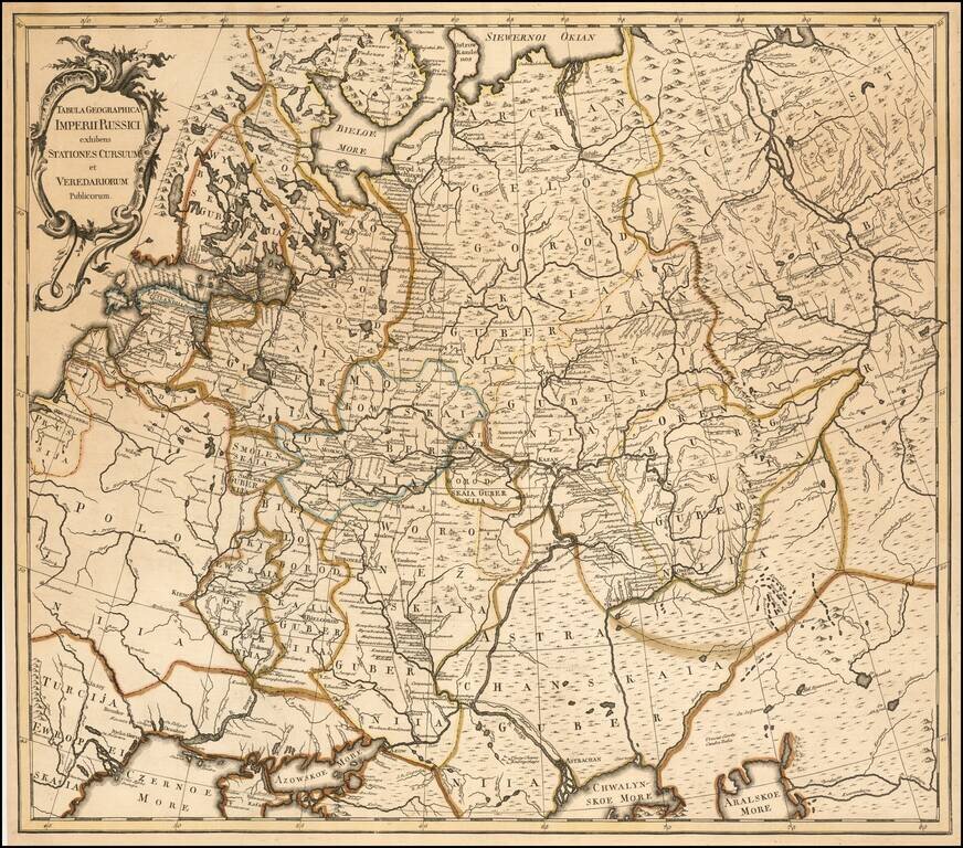
A Russian Published Map of the Russian Empire
Important map of the Russian Empire, published in St. Petersburg by Johannes Treskot
Treskot & Schmidt's survey of Russia was the next major survey following the work of Joseph Nicolas De L'Isle. Almost immediately after the publication of De l'Isle's atlas of Russia in 1745, the Geographical Department of the St. Petersburg Academy of Sciences began planning for a new atlas of Russia. For various reasons, however, an updated work would not appear for several decades. As noted by Leo Bagrow
There are frequent references to atlases of the Russian Empire published during the decades of the 1750's and 1760's…Actually, these atlases were simply loose collections of maps published the years following 1754, primarily during the period of Lomonosov and Rumovskiy…Copies of such atlases were individual collections of maps, sometimes provided with a title page which, it would seem, was usually printed in one copy only.The most prolific of these mapmakers were Johann Schmidt and Johann Treskot. Bagrow notes that these mapmakers were actively revising De L'Isle's work in the 1750s and 1760s, with Schmidt primarily focused on the Baltic Regions and Treskot on Siberia.
If you are a student, write to us in telegram: @antiquemaps and indicate what material you need and for what work you need a map in high detail. We are ready to provide material on special terms. For students only!
![[Signed Political Satire Artwork] Vietnam ... Vietnam ... Vietnam ...](/map/small/68726.jpg)

