logo

1831. Table of Mountain Chains, Together With The Altitudes of Their Princpal Summits

  • Table of Mountain Chains, Together With The Altitudes of Their Princpal Summits

Table of Mountain Chains, Together With The Altitudes of Their Princpal Summits information:

Year of creation: 
Resolution size (pixels): 
 4545x7543 px
Disk Size: 
 8.91488MiB
Number of pages: 
 1
Place: 
 Edinburgh
Author: 

Print information. Print size (Width x height in inches):
Printing at 72 dpi 
  63.13 х 104.76
Printing at 150 dpi 
 30.3 х 50.29
Printing at 300 dpi 
 15.15 х 25.14

An example of detailing the file of this map of in a printable high-resolution:

Click to open in high resolution (open in new tab).
Attention! this is just the central piece (central area 960x960 px) of the map file!
This is an example, so that you can see and study the level of detail of a given map. The entire Map will be fully available after payment!

Table of Mountain Chains, Together With The Altitudes of Their Princpal Summits

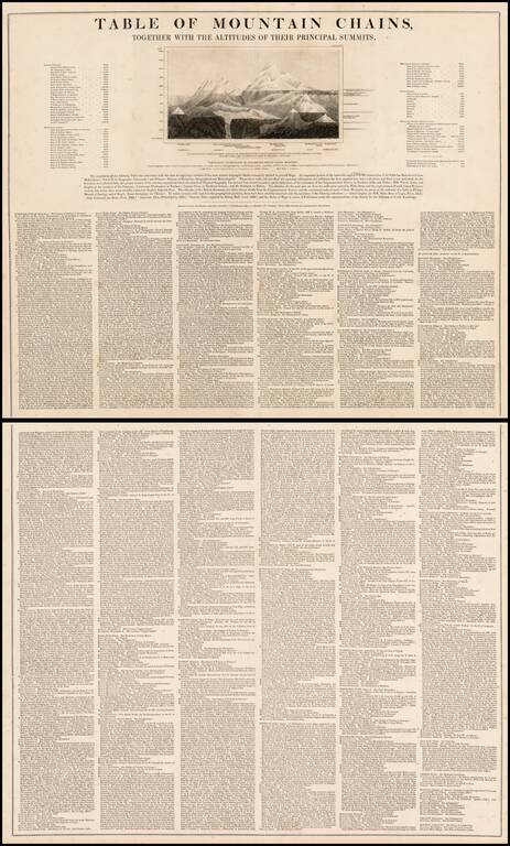
Unusual two sheet table of principal mountains, with an illustration and remarkably detailed list of mountains from all parts of the known world.

Includes a list of he tallest Island Mountains, Mountain Passes, Table Lands and Elevated Human Habitations.

The full title of the map is:

Table of mountain chains: together with the altitudes of their principal summits. (with view) Culminating points & mean height of the principal chains of mountains of Europe, America & Asia, with the lower limit of perpetual snow in different latitudes.


Special conditions for students!

If you are a student, write to us in telegram: @antiquemaps and indicate what material you need and for what work you need a map in high detail. We are ready to provide material on special terms. For students only!

Item information:

Year of creation:
Size:
4545x7543 px
Disk:
8.91488MiB
Number of pages:
1
Place:
Edinburgh
Author:
Daniel Lizars.
$14.99

Related item