Map size in jpg-format: 47.2894MiB
Click to open in high resolution (open in new tab).
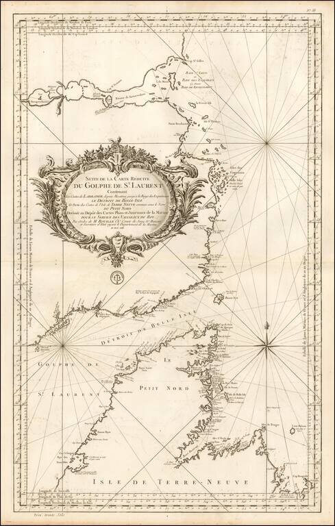
Important mid-18th Century chart of the Gulf of St. Laurence, Straits of Belle Isle and contiguous coastlines, published by Bellin, for the French Depot de la Marine.
This interesting chart is one of the most significant maps of the region. The Strait of Belle Isle divides the Island of Newfoundland from Labrador, and was long prized for its fishing and (along with the Cabot Strait) was one of the principal maritime routes to Canada. The chart carefully details the numorus harbours and bays, while rhumb lines traverse the seas.
The region was first visited by Europeans in the late 10th-century AD, whereupon the Vikings built a settlement at L'Anse aux Meadows, Newfoundland. The region was rediscovered by Basque fishermen around 1500, who founded a seasonal whaling settlement at Red Bay, Labrador. Jacques Cartier sailed through the Strait of Belle Isle during his voyages to Canada, 1534-41. Over the next two centuries the area was visited regularly by French and English fishermen in search of Whale, Cod and Seal. The main French fishing base of Chateau Bay appears on the southeastern Labrador coast.
While the present map had an approximate spatial accuracy, it is based on the informal reports of mariners, as opposed to careful surveys. It was nevertheless the most important map of the region produced during the French colonial era, which ended in 1763, following the British victory in the Seven Years War. The region would first be exactingly charted by Lieutentant James Cook (the future celebrated explorer) and Michael Lane, during the surveys conducted from 1763 to 1767.
If you are a student, write to us in telegram: @antiquemaps and indicate what material you need and for what work you need a map in high detail. We are ready to provide material on special terms. For students only!
![[The First Maps in a la poupée Printed Color] Cartes en Couleur des Lieux Sujets aux tremblements de Terre Dans toutes les parties du Monde Selon le Sisteme de l’impulsion Solaire](/map/small/52293op.jpg)

