Map size in jpg-format: 46.1596MiB
Click to open in high resolution (open in new tab).
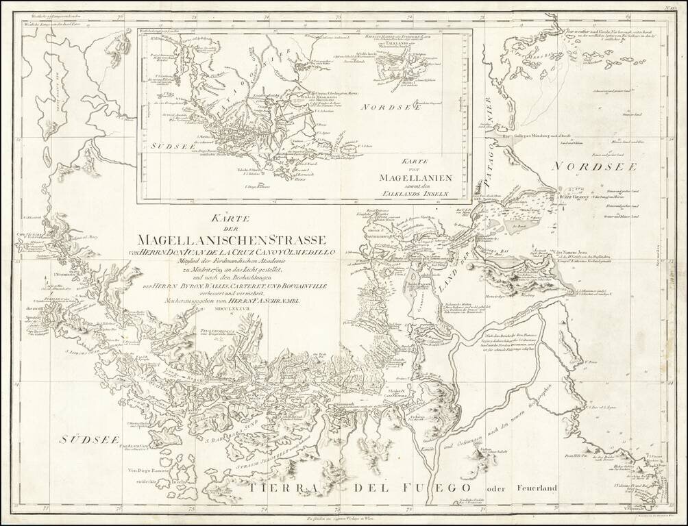
Navigating Magellan's Strait at the End of the Eighteenth Century
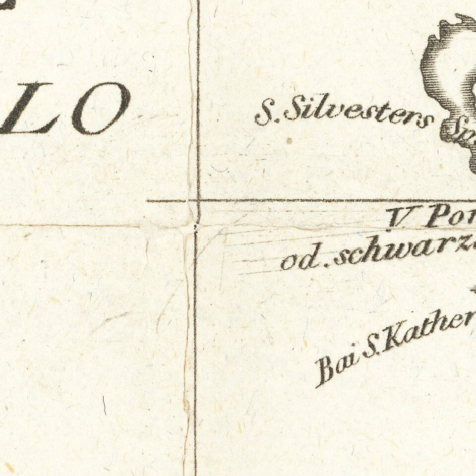
Sharply-detailed map of the Strait of Magellan, published in Vienna by F.A. Schraembl. The map provides a fine depiction of the Strait, with a large inset showing the wider region of Patagonia and the Falklands.
Place names are mainly shown in German, but they are often paired with Spanish or English equivalents for clarity. The Strait is filled with place names, notes about indigenous peoples, and notable geographic features like peaks. Hydrographic information is shared as well, with soundings, obstructions, anchorages, and directional arrows for sailing.
The title of the map credits Spanish mapmaker Juan de la Cruz Cano y Olmedilla as its primary source. This is a reference to the Mapa marítimo del Estrecho de Magallanes (1769), dedicated to Pedro Rodríguez, the Count of Campomones, a Spanish statesman. While Cruz Cano is best known for his monumental map of South America, first printed in 1775, his regional map of southern South America is also exhaustively detailed and stylishly drawn.
While Cruz Cano’s work is certainly related to this Viennese variant, this example also closely resembles A chart of the Straits of Magellan. Inlarged from the chart published at Madrid in 1769, by Don Juan de la Cruz Cano y Olmedilla of the Royal Academy of St. Fernando. and improved from the observations and surveys of Captns. Byron, Wallis and Carteret compared with those of Monsr. de Bougainville. This reissue, which includes the inset, was published by Sayer and Bennett in London in 1775.
The other sources listed for the map include the 1760s expeditions of Byron, Wallis, Carteret and Bougainville. It was published as the area became of increased interest as more and more ships passed into the Pacific to take advantage of the growing whaling and sealing trades.
The map provides an exceptional treatment of the Straits, Tierra del Fuego and the contiguous parts of Patagonia.
The European encounter with the Straits of Magellan and Tierra del Fuego
The first European voyage to the region would leave the largest legacy. Ferdinand Magellan and his crew found the entrance to the Straits and navigated the treacherous passage during his historic circumnavigation (1519-1522). It is from Magellan that we get the name Tierra del Fuego, land of fire, from the numerous fires of the indigenous peoples which he saw south of the Straights. He also named Cape of Virgins and Cape Victory, and lent his name to the Straits themselves.
Another circumnavigator, Francis Drake, passed through the Straits sixty years after Magellan. His voyage distressed the Spanish, who thought their control of the Pacific secure, and led Spanish colonial officials to appoint Pedro Sarmiento de Gamboa to attempt a settlement in the Straits. Unfortunately, the settlement failed and Thomas Cavendish, on his own circumnavigation (1586-8), found the survivors. He rescued one, along with the town’s ordnance, and abandoned twenty others. Cavendish renamed the unlucky Spanish settlement of Ciudad de Rey Don Felipe as Port Famine, in memory of the starving people he found there.
The most significant toponyms for the history of exploration are east of the South American landmass. The Dutch East India Company (VOC) had declared the Straights as their own, disallowing non-VOC ships from entering. In an attempt to circumvent these restrictions, the merchant Isaac LeMaire, Jacob’s father, financed a voyage to find an alternative route in 1615. William Schouten and Isaac Le Maire entered the Pacific from the West via a straight that sent their ships around Cape Horn, which they named for their port of departure in the Netherlands. Le Maire’s name was chosen for the Strait, while the island they passed by received the name of Staten Landt. The Schouten and Le Maire expedition also named the Barnevelt Islands after Johan van Oldenbarnevelt, governor of the province of Holland.
The Spanish, as they had been with Drake, were alarmed at the incursion and sent an expedition to verify the new strait in 1618. The Spanish commanders took along two pilots that had sailed with Schouten and Le Maire. After rounding Cape Horn they found an island they named for another of their pilots, Diego Ramirez. They were there first to circumnavigate Tierra del Fuego, proving its insularity.
Turning farther east, there is another group of islands, the Sebalds. These islands gained their name from another Dutch voyage. The Magellan Company, commanded by Oliver van Noort, and the Rotterdam Company were the only two Dutch spice fleets that navigated the Straights, the former in 1598-1601, the later in 1598-1600. The Rotterdam Company were troubled by weather and the difficult navigation. Wintering in the Straights, they lost 120 of the nearly 500 men to the conditions and, reportedly, pugnacious and giant native peoples. Frustrated and ailing, one of the commanders, Sebald de Weert, decided to return to Holland, meeting Oliver van Noort on his way home. de Weert charted islands to the northwest of the Malvinas, which appear on maps as the Sebald Islands, or the Sebalines.
Later in the seventeenth century, John Narbrough entered the Straits on the first British Admiralty sponsored voyage to the South Seas. He traversed the Straits east to west and west to east after visiting Valdivia (and leaving four of his men behind).
In the eighteenth century, Byron and Bougainville both entered the Straits as part of their states’ post-Seven Years’ War imperial voyages. Both of these men also visited the Falklands, contributing significantly to the charting and politicization of that archipelago. Byron was followed by another Admiralty voyage, that of Samuel Wallis, who sought to expand British exploratory knowledge of the Pacific.
If you are a student, write to us in telegram: @antiquemaps and indicate what material you need and for what work you need a map in high detail. We are ready to provide material on special terms. For students only!