
Map size in jpg-format: 248.669MiB
Click to open in high resolution (open in new tab).

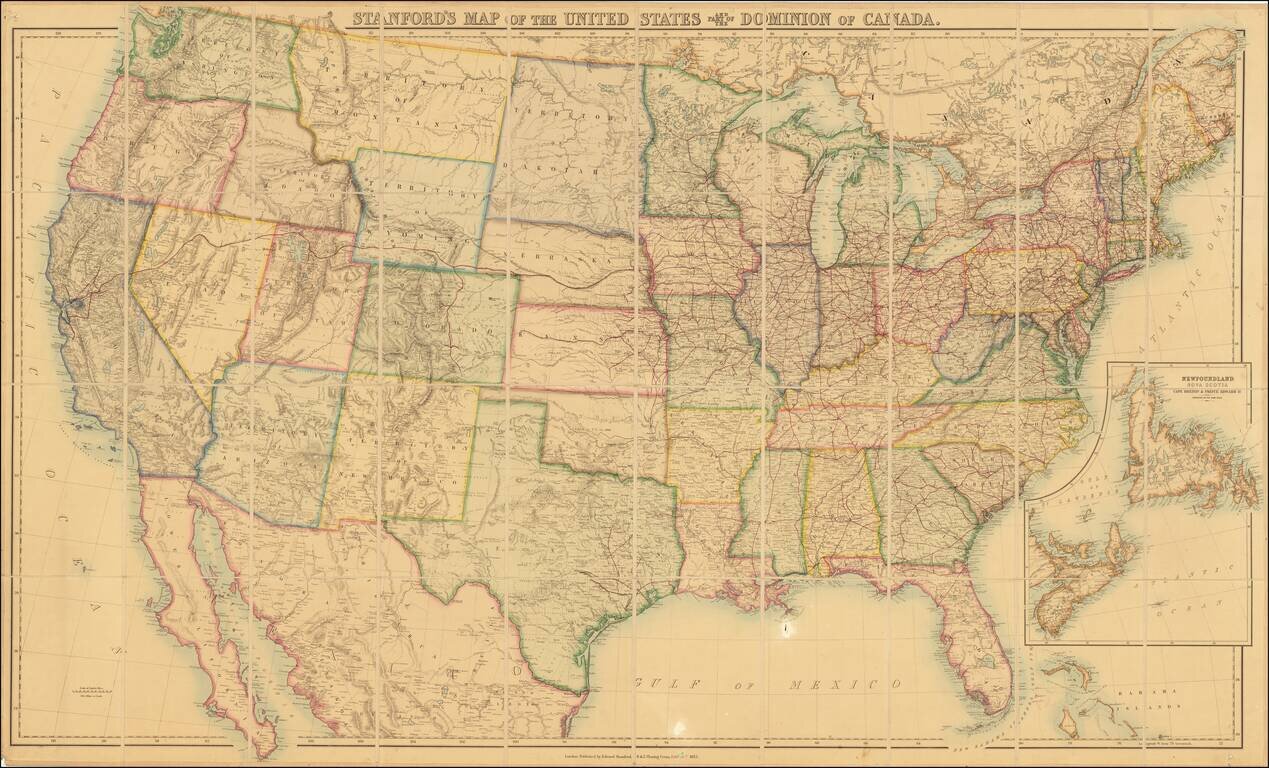
Remarkable large format map of the United States, showing the US immediately after the completion of the first transcontinental railroad.
Stanford's map of the United States has a long and interesting history. First published by Rogers & Johnston in 1857, it was updated on a regular basis over the next 20 years and utilized in the production of 3 atlases, the Rogers & Johnston Atlas of the United States, The People's Pictorial Atlas and later by Hardesty in several productions in 1875.
The map provides a marvelously detailed treatment of the Transmississippi West, as updated annually by England's primary commercial map maker of the period. The extent of the Railroads as of about 1872 is shown in red. A note in Indian Territory notes that it was "Ceded in 1866," a curious description of the US exercise of dominion over the lands of the Indian Nations then in residence.
The map curiously shows Idaho Territory without its northern panhandle, a feature which would be corrected by 1875 (see link below). The map provides a fine snapsnot of the United States shortly before the explosion or railroads in the west. An image of the 1875 edition of the map is shown here: /gallery/detail/20828
Edward Stanford (1827-1904) was a prominent British mapmaker and publisher. A native of Holborn in the heart of London, Edward was apprenticed to a printer and stationer at the age of 14. After his first master died, he worked with several others, including Trelawny W. Saunders of Charing Cross. Saunders oversaw young Edward’s early career, ensuring that he became a Fellow of the Royal Geographical Society. Associations with the Society eventually brought Sanders much business and gave him a reputation as a publisher of explorers. As testament to this reputation, the Stanford Range in British Columbia was named for him by John Palliser.
Stanford briefly partnered with Saunders in 1852 before striking out on his own in 1853. He was an agent for the Ordnance Survey, the Admiralty, the Geological Survey, the Trigonometrical Survey of India, and the India Office. He also controlled the maps of the Society for the Diffusion of Useful Knowledge, another lucrative source of income. In 1857, Stanford founded his namesake Geographical Establishment, with Saunders and A. K. Johnston as engravers. Thereafter, Stanford was known for his “library maps”, particularly those of Africa and Asia.
Although he had authored many maps, the Harrow Atlas of Modern Geography and a similar volume on classical geography, Stanford is better remembered today as the leader of a successful map business. Ever in search of more inventory, he acquired the plates and stock of John Arrowsmith, heir of the Arrowmsith family firm, in 1874. By 1881 he employed 87 people at his premises at 6 Charing Cross Road, Saunders’ old address. As he aged, he phased in his son Edward Jr. to run the business. He died in 1904. The business survived him, and the Stanford’s shop is still a prominent London landmark today.
If you are a student, write to us in telegram: @antiquemaps and indicate what material you need and for what work you need a map in high detail. We are ready to provide material on special terms. For students only!

![[Signed Political Satire Artwork] Vietnam ... Vietnam ... Vietnam ...](/map/small/68726.jpg)
