Map size in jpg-format: 47.9158MiB
Click to open in high resolution (open in new tab).

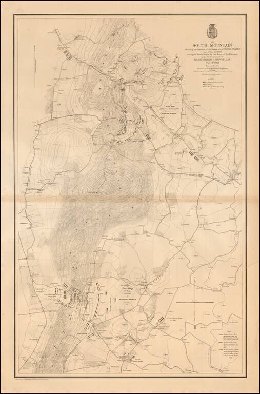
Large, detailed lithographed map of the Battle of South Mountain, a somewhat mixed Union Victory, which set the stage for the Battle of Antietam three days later.
The Civil War Trust says of the Battle of South Mountain:
After his success at Second Manassas, Gen. Robert E. Lee led the Army of Northern Virginia north across the Potomac River on an invasion of Maryland in September of 1862. Lee divided his army, sending a portion of it into western Maryland while Lieut. Gen. Stonewall Jackson's wing attempted to capture the Federal garrison at Harper's Ferry. The bold plan was jeopardized on September 13th when a mislaid copy of Lee's orders revealing the Confederates' plans was given to Union commander Maj. Gen. George B. McClellan. The next day, emboldened by this intelligence, McClellan moved his six army corps into the three passes on South Mountain in order to destroy the Confederate defenders there and divide Lee's army. Maj. Gen. Joseph Hooker at Turner's Gap, Maj. Gen. Jesse Reno at Fox's Gap, and Maj. Gen. William B. Franklin at Crampton's Gap all gained success with their forces against Maj. Gen. D. H. Hill and other elements of Lieut. Gen. James Longstreet's wing of Lee's army. Finally defeated in battle by McClellan, Lee withdrew Longstreet's men to the west. Though the Federals ultimately gained control of all three passes, stubborn resistance on the part of the Southerners bought Lee precious time to begin the process of reuniting his army, and set the stage for the Battle of Antietam three days later.
If you are a student, write to us in telegram: @antiquemaps and indicate what material you need and for what work you need a map in high detail. We are ready to provide material on special terms. For students only!