logo

1914. (Red River Colony) Map of the District of Assiniboia, 1811

  • (Red River Colony)  Map of the District of Assiniboia, 1811

(Red River Colony) Map of the District of Assiniboia, 1811 information:

Year of creation: 
Resolution size (pixels): 
 12766x10592 px
Disk Size: 
 15.7332MiB
Number of pages: 
 1
Place: 
 Ottawa
Author: 

Print information. Print size (Width x height in inches):
Printing at 72 dpi 
  177.31 х 147.11
Printing at 150 dpi 
 85.11 х 70.61
Printing at 300 dpi 
 42.55 х 35.31

An example of detailing the file of this map of in a printable high-resolution:

Click to open in high resolution (open in new tab).
Attention! this is just the central piece (central area 960x960 px) of the map file!
This is an example, so that you can see and study the level of detail of a given map. The entire Map will be fully available after payment!

(Red River Colony)  Map of the District of Assiniboia, 1811

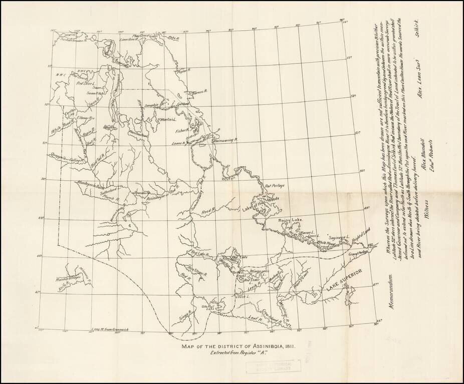
Early copy of one of the original maps delineating the Red River Colony, undertaken by Alex Lean, surveyor, in Selkirk.

The name District of Assiniboia was used to describe the Red River Colony, (for official purposes), between 1812 and 1869.

An important map for the early history of the region.


Special conditions for students!

If you are a student, write to us in telegram: @antiquemaps and indicate what material you need and for what work you need a map in high detail. We are ready to provide material on special terms. For students only!

Item information:

Year of creation:
Size:
12766x10592 px
Disk:
15.7332MiB
Number of pages:
1
Place:
Ottawa
Author:
Anonymous.
$14.99

Related item