logo

1883. Real Estate Map of the Adjacent Suburbs of Chicago Including The Towns of Evanston, Lake View, Jefferson, Norwood Park, and the east half of Leyden, Cicero, Riverside, and the east half of Proviso, the north half of Hyde Park, the east two thirds of Lyons

  • Real Estate Map of the Adjacent Suburbs of Chicago Including The Towns of Evanston, Lake View, Jefferson, Norwood Park, and the east half of Leyden, Cicero, Riverside, and the east half of Proviso, the north half of Hyde Park, the east two thirds of Lyons
  • Real Estate Map of the Adjacent Suburbs of Chicago Including The Towns of Evanston, Lake View, Jefferson, Norwood Park, and the east half of Leyden, Cicero, Riverside, and the east half of Proviso, the north half of Hyde Park, the east two thirds of Lyons

Real Estate Map of the Adjacent Suburbs of Chicago Including The Towns of Evanston, Lake View, Jefferson, Norwood Park, and the east half of Leyden, Cicero, Riverside, and the east half of Proviso, the north half of Hyde Park, the east two thirds of Lyons information:

Year of creation: 
Resolution size (pixels): 
 21105x28318 px
Disk Size: 
 161.543MiB
Number of pages: 
 2
Place: 
 Chicago
Author: 

Print information. Print size (Width x height in inches):
Printing at 72 dpi 
  293.13 х 393.31
Printing at 150 dpi 
 140.7 х 188.79
Printing at 300 dpi 
 70.35 х 94.39

An example of detailing the file of this map of in a printable high-resolution:

Click to open in high resolution (open in new tab).
Attention! this is just the central piece (central area 960x960 px) of the map file!
This is an example, so that you can see and study the level of detail of a given map. The entire Map will be fully available after payment!

Real Estate Map of the Adjacent Suburbs of Chicago Including The Towns of Evanston, Lake View, Jefferson, Norwood Park, and the east half of Leyden, Cicero, Riverside, and the east half of Proviso, the north half of Hyde Park, the east two thirds of Lyons

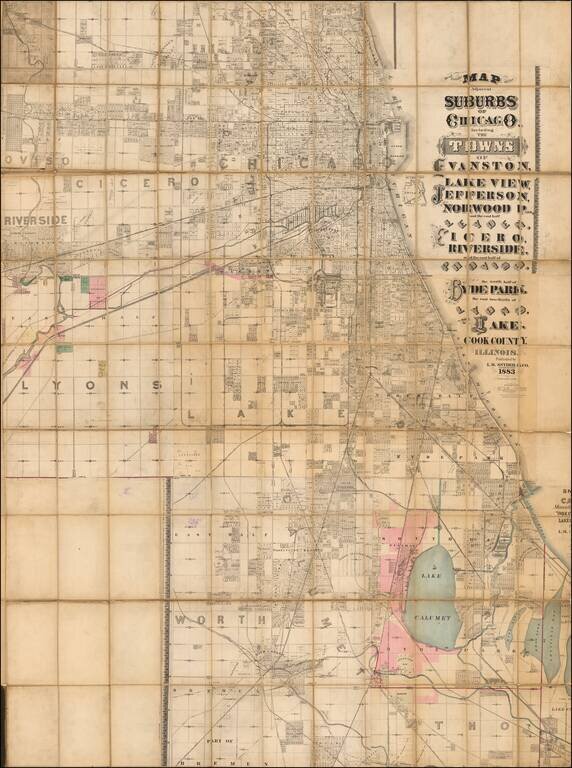
Massive, Detailed Wall Map of Chicago from the 1880s.

L.M. Snyder & Co.'s extremely rare lithographed folding map of Chicago, published in Chicago during its major late-19th-century real estate boom.

The map has considerable detail for its size; all streets are named, many blocks are numbered, subdivisions are labeled, railroad tracks are shown.

Most of the hand-coloring is in allotments in Lyons and around Lake Calumet. There is a manuscript indication of a railroad extension running through the Walker's Dock Addition.

Snyder was responsible for a number of large Chicago real estate maps in the 1880s.

1880s Boom Time in Chicago

The climate of 1880s Chicago is summed up well in this entry in the Encyclopedia of Chicago History:

The most obvious change--especially in the eyes of visitors--came in the growth of the city itself. Ever since the Fire of 1871, the city seemed to be on a building spree that fueled the local economy and provided both business opportunities and jobs. The 1880 manufacturing census, for example, counted 171 carpentering establishments employing 1,792 employees. By 1890, the same census enumerated 500 establishments with 6,223 employees. New technologies generated new jobs, as the city's infrastructure simultaneously enhanced growth while expanding in response to development. In 1880, 358 employees worked for 86 Chicago plumbing and gasfitting firms. As running water, sewer connections, and gas for lighting and cooking become more common in both residential and business buildings in the 1880s, those figures jumped to 2,586 employees at 278 firms.

Phillips, Maps, Volume 1, page 231.

Special conditions for students!

If you are a student, write to us in telegram: @antiquemaps and indicate what material you need and for what work you need a map in high detail. We are ready to provide material on special terms. For students only!

Item information:

Year of creation:
Size:
21105x28318 px
Disk:
161.543MiB
Number of pages:
2
Place:
Chicago
Author:
L.M. Snyder & Co..
$21.99

Related item