logo

1689. Provinces-Unies Des Pays-Bas avec leurs Acquisitions dans la Flandre, le Brabant, le Limburg, et le Lyege et les Paces qu'elles tiennent sur le Rhein le Duche de Cleves, et dans L'Archevesche et Eslectorat de Cologne . . . 1689

  • Provinces-Unies Des Pays-Bas avec leurs Acquisitions dans la Flandre, le Brabant, le Limburg, et le Lyege et les Paces qu'elles tiennent sur le Rhein le Duche de Cleves, et dans L'Archevesche et Eslectorat de Cologne . . . 1689

Provinces-Unies Des Pays-Bas avec leurs Acquisitions dans la Flandre, le Brabant, le Limburg, et le Lyege et les Paces qu'elles tiennent sur le Rhein le Duche de Cleves, et dans L'Archevesche et Eslectorat de Cologne . . . 1689 information:

Year of creation: 
Resolution size (pixels): 
 7299x4858 px
Disk Size: 
 8.80299MiB
Number of pages: 
 1
Place: 
 Paris

Print information. Print size (Width x height in inches):
Printing at 72 dpi 
  101.38 х 67.47
Printing at 150 dpi 
 48.66 х 32.39
Printing at 300 dpi 
 24.33 х 16.19

An example of detailing the file of this map of in a printable high-resolution:

Click to open in high resolution (open in new tab).
Attention! this is just the central piece (central area 960x960 px) of the map file!
This is an example, so that you can see and study the level of detail of a given map. The entire Map will be fully available after payment!

Provinces-Unies Des Pays-Bas avec leurs Acquisitions dans la Flandre, le Brabant, le Limburg, et le Lyege et les Paces qu'elles tiennent sur le Rhein le Duche de Cleves, et dans L'Archevesche et Eslectorat de Cologne . . . 1689

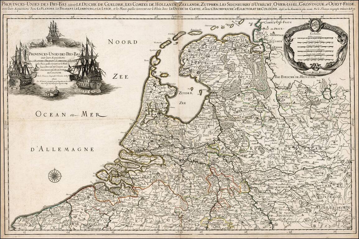
Rare variant edition of Jaillot's map of the Low Countries.

The present example, dated 1689, includes an elaborate ships motif for the title cartouche. We were not able to locate another example of this map illustrated on the internet or elsewhere.

Alexis-Hubert Jaillot (ca. 1632-1712) was one of the most important French cartographers of the seventeenth century. Jaillot traveled to Paris with his brother, Simon, in 1657, hoping to take advantage of Louis XIV's call to the artists and scientists of France to settle and work in Paris. Originally a sculptor, he married the daughter of Nicholas Berey, Jeanne Berey, in 1664, and went into partnership with Nicholas Sanson's sons. Beginning in 1669, he re-engraved and often enlarged many of Sanson's maps, filling in the gap left by the destruction of the Blaeu's printing establishment in 1672.


Special conditions for students!

If you are a student, write to us in telegram: @antiquemaps and indicate what material you need and for what work you need a map in high detail. We are ready to provide material on special terms. For students only!

Item information:

Year of creation:
Size:
7299x4858 px
Disk:
8.80299MiB
Number of pages:
1
Place:
Paris
Author:
Alexis-Hubert Jaillot.
$14.99

Related item