logo

1692. Provinces-Unies Des Pays-Bas avec leurs Acquisitions dans la Flandre, le Brabant, le Limbourg, et le Lyege et les Places qu'elles possedoient sur le Rhein, dans le Duche de Cleves, et dans L'Archevesche et Eslectorat de Cologne ...

  • Provinces-Unies Des Pays-Bas avec leurs Acquisitions dans la Flandre, le Brabant, le Limbourg, et le Lyege et les Places qu'elles possedoient sur le Rhein, dans le Duche de Cleves, et dans L'Archevesche et Eslectorat de Cologne ...

Provinces-Unies Des Pays-Bas avec leurs Acquisitions dans la Flandre, le Brabant, le Limbourg, et le Lyege et les Places qu'elles possedoient sur le Rhein, dans le Duche de Cleves, et dans L'Archevesche et Eslectorat de Cologne ... information:

Year of creation: 
Resolution size (pixels): 
 22456x14741 px
Disk Size: 
 57.364MiB
Number of pages: 
 1
Place: 
 Paris

Print information. Print size (Width x height in inches):
Printing at 72 dpi 
  311.89 х 204.74
Printing at 150 dpi 
 149.71 х 98.27
Printing at 300 dpi 
 74.85 х 49.14

An example of detailing the file of this map of in a printable high-resolution:

Click to open in high resolution (open in new tab).
Attention! this is just the central piece (central area 960x960 px) of the map file!
This is an example, so that you can see and study the level of detail of a given map. The entire Map will be fully available after payment!

Provinces-Unies Des Pays-Bas avec leurs Acquisitions dans la Flandre, le Brabant, le Limbourg, et le Lyege et les Places qu'elles possedoient sur le Rhein, dans le Duche de Cleves, et dans L'Archevesche et Eslectorat de Cologne ...

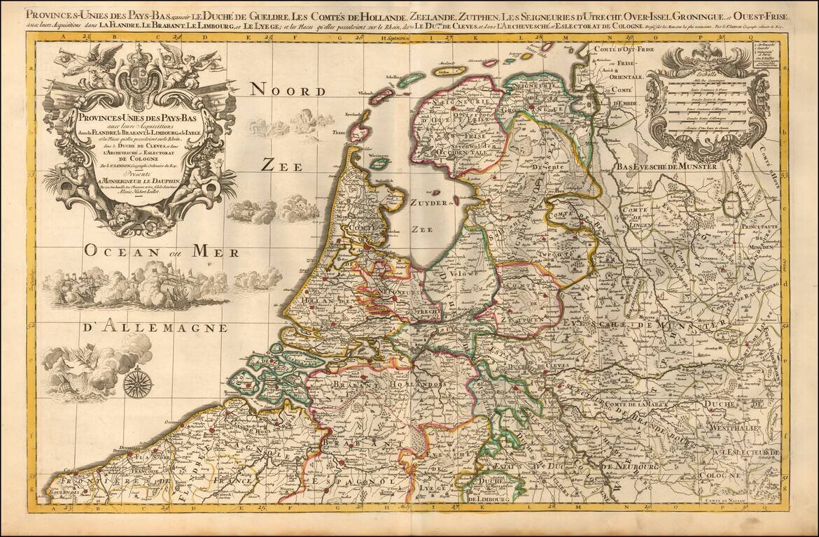
A finely detailed map of the Low Countries, published in Paris.

The map illustrates the united provinces of the Low Countries including Flanders, Brabant, Limburg, Lyege, etc. It also notes archdiocese and bishop's palaces throughout the region.

The map includes an ornate title cartouche along with a scale of miles. It also includes beautifully engraved naval battle scenes and a compass rose within the North Sea (also known as the German Ocean).

Alexis-Hubert Jaillot (ca. 1632-1712) was one of the most important French cartographers of the seventeenth century. Jaillot traveled to Paris with his brother, Simon, in 1657, hoping to take advantage of Louis XIV's call to the artists and scientists of France to settle and work in Paris. Originally a sculptor, he married the daughter of Nicholas Berey, Jeanne Berey, in 1664, and went into partnership with Nicholas Sanson's sons. Beginning in 1669, he re-engraved and often enlarged many of Sanson's maps, filling in the gap left by the destruction of the Blaeu's printing establishment in 1672.


Special conditions for students!

If you are a student, write to us in telegram: @antiquemaps and indicate what material you need and for what work you need a map in high detail. We are ready to provide material on special terms. For students only!

Item information:

Year of creation:
Size:
22456x14741 px
Disk:
57.364MiB
Number of pages:
1
Place:
Paris
Author:
Alexis-Hubert Jaillot.
$21.99

Related item