logo

1775. ( Prince Edward Island ) A Map of the Island of St. John In the Gulf of St. Laurence Divided Into Counties & Parishes And the Lots as granted by Government, to which is added The Soundings round the Coast & Harbours Improved from the late Survey of Capta

  • ( Prince Edward Island )  A Map of the Island of St. John In the Gulf of St. Laurence Divided Into Counties & Parishes And the Lots as granted by Government, to which is added The Soundings round the Coast & Harbours Improved from the late Survey of Capta

( Prince Edward Island ) A Map of the Island of St. John In the Gulf of St. Laurence Divided Into Counties & Parishes And the Lots as granted by Government, to which is added The Soundings round the Coast & Harbours Improved from the late Survey of Capta information:

Year of creation: 
Resolution size (pixels): 
 9174x6830 px
Disk Size: 
 9.43331MiB
Number of pages: 
 1
Place: 
 London
Author: 

Print information. Print size (Width x height in inches):
Printing at 72 dpi 
  127.42 х 94.86
Printing at 150 dpi 
 61.16 х 45.53
Printing at 300 dpi 
 30.58 х 22.77

An example of detailing the file of this map of in a printable high-resolution:

Click to open in high resolution (open in new tab).
Attention! this is just the central piece (central area 960x960 px) of the map file!
This is an example, so that you can see and study the level of detail of a given map. The entire Map will be fully available after payment!

( Prince Edward Island )  A Map of the Island of St. John In the Gulf of St. Laurence Divided Into Counties & Parishes And the Lots as granted by Government, to which is added The Soundings round the Coast & Harbours Improved from the late Survey of Capta

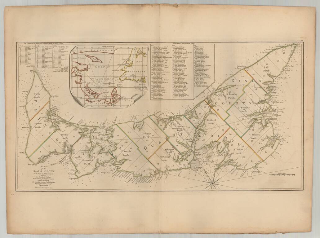
Important early map of St. Johns Island, published by Thomas Jefferys in the American Atlas.

The map provides a finely detailed treatment of the island and environs, including a list of 67 lots and the proprietors of each lot, including Samuel Holland himself (Lot 28). Many other important early names are included in the list, including Guy Carleton (then provincial Governor of Canada), Thomas Desbrisay, Hugh Palliser, Augustus Keppel, etc.


Special conditions for students!

If you are a student, write to us in telegram: @antiquemaps and indicate what material you need and for what work you need a map in high detail. We are ready to provide material on special terms. For students only!

Item information:

Year of creation:
Size:
9174x6830 px
Disk:
9.43331MiB
Number of pages:
1
Place:
London
Author:
Samuel Holland.
$14.99

Related item