Map size in jpg-format: 315695B
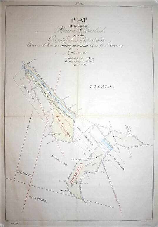
Fascininating Clear Creek County, Colorado Plat Map and GLO Mineral Certificate, confirming the mining claim of Marcus W. Rasbach to mining rights first claimed on June 30, 1881.
A fine example of a General Land Office Mineral Certificate, consisting of a finely engraved frontice masthead of the United States of America General Land Office, finely executed manuscript plat map and mostly manuscript text (12 pages), along with an elaborate official seal, original silk ties and facsimile signature of Chester A. Arthur, President of the United States of America.
The finely executed manuscript Plat Map (200 feet to 1 inch) of Rasbach's claim shows an area along South Clear Creek, which includes the route of the Central Colorado Railroad, a flume, 2 houses and a barn, along with 3 shafts and the location of the pits.
Marcus W. Rasbach appears to have led a fascinating double life. In 1873, he is listed as the Treasurer of the Herkimer & Mohawk Railroad. In this same period, Rasbach also served as Cashier at the Herkimer Bank in New York and operated a provisions store in Herkimer. GLO records show that between 1876 and 1887, Marcus W. Rasbach also acquired 17 mining claims totalling approximately 710 acres, making him a relatively large holder of such claims. Contemporary newspaper accounts note that on December 13, 1888, Rasbacher left Herkimer suddenly and was later discovered to have embezzled over $33,000 from the Herkimer Bank. Contemporary accounts note that he apparently lost significant money in speculative investments, which led to his demise. No mention of his activities in the West are included in these accounts and were apparently unknown at the time.
While we have been unable to definitively link these two events, the correlation between the acquisition of Rasbacher's Colorado mining claims and the New York Bank embezzlement is strong circumstantial evidence that it is the same person, as is the fact that Rasbach's two known partners listed by the GLO on 2 of his claims were Mary Lewis and William Lewis, both of whom can be traced to Herkimer County, New York, in the same time period.
Clear Creek was originally named Cannonball Creek. The name can be traced to the Stephen H. Long expedition. In the 1830s, Cannonball Creek became known as Vasquez Fork and Vasquez River, after the fur trader Louis Vasquez who had his fort at the mouth of the river and trapped along its banks. The modern name of Clear Creek can be traced to the Gold Rush of 1859. The creek is famous as the location of the most intense early mining activity during the Colorado Gold Rush of 1859. Rasbach's claim is relatively late in Clear Creek's history, which may account for his failure.
The General Land Office (GLO) refers to the independent agency in the United States that was in charge of public domain lands. Created in 1812, it assumed the responsibilities for public domain lands from the United States Department of the Treasury. The Treasury had overseen the survey of the Northwest Territory, but as more area was added to the United States, a new agency was necessary to survey the new lands.
Eventually, the GLO would be responsible for the surveying, platting, and sale of the majority of the land west of the Mississippi, with the exception of Texas. When the Secretary of the Interior was created in 1849, the GLO was placed under its authority. Until the creation of the Forest Service in 1905, the GLO also managed forest lands that had been removed from public domain. In additional to managing the fees and sales of land, the GLO produced maps and plans of the areas and plots they surveyed. In 1946, the GLO merged with the United States Grazing Service to become the Bureau of Land Management.
If you are a student, write to us in telegram: @antiquemaps and indicate what material you need and for what work you need a map in high detail. We are ready to provide material on special terms. For students only!

![Carte Du Mexique et de la Floride des Terres Angloises et des Isles Antilles du Cours et des Environs de la Riviere Mississipi . . . Rue Des Canettes . . . 1703 [1st State]](/map/small/66307op.jpg)