Map size in jpg-format: 771343B
Click to open in high resolution (open in new tab).
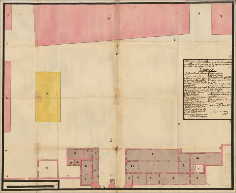
Manuscript Plan of Veracruz's Plaza Contaduria, the Accounting Place of Empire
This is a plan of one of Veracruz's plazas. This particular plaza, Contaduria, was used to monitor commerce, as Veracruz was the most important port in New Spain. The plan is signed by a Miguel de Cerras and is dated August 12, 1791.
The plan shows the Plaza Contaduria, or the Plaza of Accounting. It includes its buildings, their exits to the streets, and the way to the pier, where ships were unloaded. The areas in pink are buildings, probably barracks, that face the sea (T, V) and which close off the plaza (X). The yellow area is where people can seek manufactured goods.
At the bottom are several buildings. This is the entrance and exit to the pier, while the surrounding buildings include a chapel (B), a guardhouse (C), offices, depositories (F), the Registry Office (G), the Tribunal (J), the warehouse of the Royal Treasure (referring to the goods brought on the annual flotilla from Spain) (M), and a provisional powder store (R).
Veracruz was an important city in the Spanish American empire. From the sixteenth century, Spain operated a closed monopoly of trade with its colonies; the colonies were only allowed to trade in Spanish goods brought on Spanish ships, although many smugglers and pirates undermined this system. Veracruz was the port on New Spain's eastern coast that received the Spanish treasure galleons, while Acapulco served this function on the west coast. The goods were then taken by wagon to the interior and sold at lucrative fairs; each fair produced around 20 million pesos worth of trade.
By the time this map was made, in 1791, Spain has begun to ease it closed policy. The last flotilla arrived in 1778, after which Spain began allowing foreign traders to unload and sell their wares in port cities, including Veracruz. They would have had to bring their cargoes to the Plaza Contaduria for inspection and valuation before being sold.
Veracruz was founded by Cortez when he landed on the mainland of New Spain in 1519. It received a coat of arms in 1523, the first place on mainland America to receive one. Veracruz's main exports were silver and gold, while its imports were numerous as Spain forbid the manufacturing of many goods in the New World.
From initial contact until today, Veracruz has been Mexico's most prominent port and it was the last place that Spain gave up when Mexico became independent. Most of Mexico was liberated in 1821, but the Spanish held the island off of Veracruz, San Juan de Ulua, until 1825. This manuscript plan shows some of the infrastructure that made Veracruz so important to Mexicans and Spaniards alike.
Transcription of the title and key:
Plano que manifiesta la Plaza nombrada de Contraduria, y los Edificis que la constituyen; con los respectivas desembocaduras de las Calles, y salida al Muelle Explicación.
Veracruz Ag/to. 12 de 1791.
Migl del Corras [paraph]
If you are a student, write to us in telegram: @antiquemaps and indicate what material you need and for what work you need a map in high detail. We are ready to provide material on special terms. For students only!


![Map of Mexico, Central America, and the West Indies [Insets of Bermuda, Sandwich Islands, Jamaica and Panama Railroad]](/map/small/69133.jpg)