logo

1829. Plan of that Part of the Isthmus of Panama Eligible for effecting a Communication Between The Atlantic & Pacific from Observations & Surveys performed in the Years 1828 & 1829, By J.A. Lloyd.

  • Plan of that Part of the Isthmus of Panama Eligible for effecting a Communication Between The Atlantic & Pacific from Observations & Surveys performed in the Years 1828 & 1829, By J.A. Lloyd.

Plan of that Part of the Isthmus of Panama Eligible for effecting a Communication Between The Atlantic & Pacific from Observations & Surveys performed in the Years 1828 & 1829, By J.A. Lloyd. information:

Year of creation: 
Resolution size (pixels): 
 5463x5800 px
Disk Size: 
 4.53791MiB
Number of pages: 
 1
Place: 
 London

Print information. Print size (Width x height in inches):
Printing at 72 dpi 
  75.88 х 80.56
Printing at 150 dpi 
 36.42 х 38.67
Printing at 300 dpi 
 18.21 х 19.33

An example of detailing the file of this map of in a printable high-resolution:

Click to open in high resolution (open in new tab).
Attention! this is just the central piece (central area 960x960 px) of the map file!
This is an example, so that you can see and study the level of detail of a given map. The entire Map will be fully available after payment!

Plan of that Part of the Isthmus of Panama Eligible for effecting a Communication Between The Atlantic & Pacific from Observations & Surveys performed in the Years 1828 & 1829, By J.A. Lloyd.

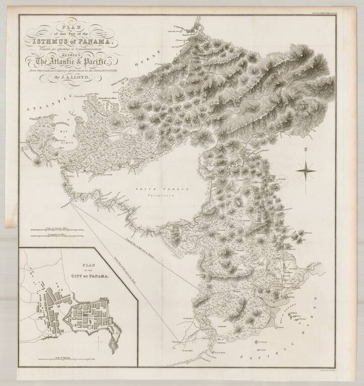
Finely detailed map of a portion of Panama, prepared to illustrate John Augustus Lloyd's article Account of Levellings Carried Across the Isthmus of Panama, presented at the Royal Geographical Society in 1830.

This detailed topographical map depicts the region surrounding the narrowest portion of the Isthmus of Panama, based on surveys conducted by John Augustus Lloyd between 1828 and 1829. Around the time that railroads were being invented, President Bolivar of Gran Colombia commissioned a study of the area between Chagres and Panama City with the intent of building a railroad to connect the Atlantic to the Pacific Ocean. Although the report concluded that a railroad was possible, the project was abandoned until 1850, when US privateers began building the Panama Railroad.

This map depicts two potential rail road lines to the Pacific, both extending from the River Trinidad: the nearest line and a proposed line. A large inset shows a bird's-eye plan of Panama City.


Special conditions for students!

If you are a student, write to us in telegram: @antiquemaps and indicate what material you need and for what work you need a map in high detail. We are ready to provide material on special terms. For students only!

Item information:

Year of creation:
Size:
5463x5800 px
Disk:
4.53791MiB
Number of pages:
1
Place:
London
Author:
Royal Geographical Society.
$14.99

Related item