logo

1797. Plan du Port des Francais sur la Cote du Nord-Ouest de l'Amerique, par 58°37' de Latitude Nord et 139°50' de Longitude Occidentale, Decouverte le 2 Juillet 1786, par les Fregates Francaise la Boussole et l'Astrolabe.

  • Plan du Port des Francais sur la Cote du Nord-Ouest de l'Amerique, par 58°37' de Latitude Nord et 139°50' de Longitude Occidentale, Decouverte le 2 Juillet 1786, par les Fregates Francaise la Boussole et l'Astrolabe.

Plan du Port des Francais sur la Cote du Nord-Ouest de l'Amerique, par 58°37' de Latitude Nord et 139°50' de Longitude Occidentale, Decouverte le 2 Juillet 1786, par les Fregates Francaise la Boussole et l'Astrolabe. information:

Year of creation: 
Resolution size (pixels): 
 8835x6577 px
Disk Size: 
 13.0655MiB
Number of pages: 
 1
Place: 
 Paris

Print information. Print size (Width x height in inches):
Printing at 72 dpi 
  122.71 х 91.35
Printing at 150 dpi 
 58.9 х 43.85
Printing at 300 dpi 
 29.45 х 21.92

An example of detailing the file of this map of in a printable high-resolution:

Click to open in high resolution (open in new tab).
Attention! this is just the central piece (central area 960x960 px) of the map file!
This is an example, so that you can see and study the level of detail of a given map. The entire Map will be fully available after payment!

Plan du Port des Francais sur la Cote du Nord-Ouest de l'Amerique, par 58°37' de Latitude Nord et 139°50' de Longitude Occidentale, Decouverte le 2 Juillet 1786, par les Fregates Francaise la Boussole et l'Astrolabe.

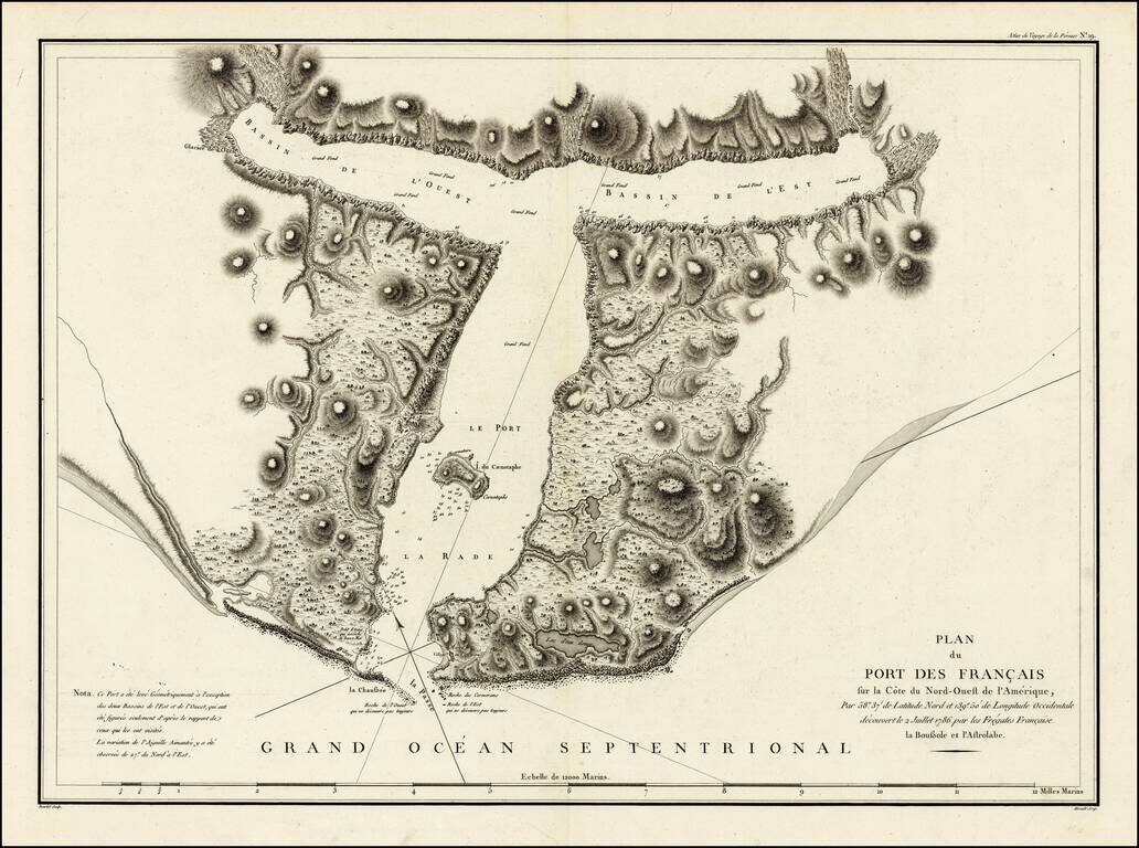
Detailed plan of Port des Francais, from the Atlas Du Voyage De La Pérouse.

From the voyages of La Pérouse who set sail from France in 1785 to continue the discoveries of Captain Cook. He was shipwrecked in 1788 and died during the voyage, but his narrative, maps, and views survived and were published in 1797. Thirty-eight years later the scattered remains of La Boussole and L'Astrolabe was discovered wrecked on a vicious reef on an atoll in the New Hebrides. Attractive sea chart showing the entrance to Port des Français. Engraved by BOUCLET.


Special conditions for students!

If you are a student, write to us in telegram: @antiquemaps and indicate what material you need and for what work you need a map in high detail. We are ready to provide material on special terms. For students only!

Item information:

Year of creation:
Size:
8835x6577 px
Disk:
13.0655MiB
Number of pages:
1
Place:
Paris
Author:
Jean Francois Galaup de La Perouse.
$14.99

Related item