Map size in jpg-format: 13.344MiB
Click to open in high resolution (open in new tab).
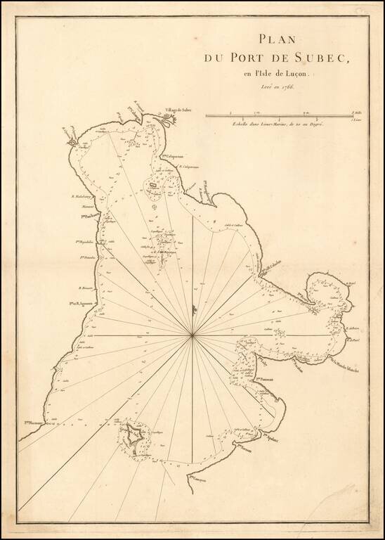
A rare sea chart of Subic Bay in the Philippines, which appeared in the second edition of Mannetvillette's Le Neptune Oriental, published in 1775.
The chart is one of the earliest obtainable detail charts of Subic Bay.
Subic Bay was discovered by the Spanish explorer Juan de Salcedo, who reported its existence to the Spanish authorities in 1542, upon his return to Manila after Salcedo arrived in Zambales to establish the Spanish crown.
The present chart was drafted by Jean-Batiste de Mannevillette (1707-80), and engraved on copper by the master engraver Guillaume Dheulland. Mannevillette apprenticed under the great royal cartographer Guillaume De L'Isle. He then joined the maritime service of the Compagnie des Indes, eventually attaining the rank of captain. Upon his return to Paris, Mannevillette was appointed as director of the Dépôt des Cartes et Plans de la Navigation des Indes. In 1745, he published the first edition of his sea atlas of Asian waters, Le Neptune Oriental. While not included in the atlas, it seems that the production of the present chart was closely associated with this project. The high quality of Mannevillette's charts won him the acclaim of both mariners and academics alike, and he was admitted as a fellow of the Academy of Sciences. He published a second, heavily revised, edition of the Neptune Oriental in 1775.
If you are a student, write to us in telegram: @antiquemaps and indicate what material you need and for what work you need a map in high detail. We are ready to provide material on special terms. For students only!
![[Martin Behaim Globe / Book] Pars Globi terrestris Ao. 1492 a Martino Behaim Equite Lusitano Norimbergae confecti Delineavit Christoph. Theoph de Murr 1778 (bound with:) Diplomatische Geschichte des Portugesischen berühmten Ritters Martin Behaims](/map/small/68828.jpg)
![Il Disegno Della Terza Parte Dell' Asia [Gastaldi's Wall Map of SE Asia with extra panels!]](/map/small/30554hbp.jpg)
![Chinae, olim Sinarum regionis nova descriptio. auctore Ludouico Georgio. [English Edition!]](/map/small/71123.jpg)