logo

1797. Plan de la Baie D'Estaing Situee a la Cote de Tchoka. . . (American Samoa)

  • Plan de la Baie D'Estaing Situee a la Cote de Tchoka. . .   (American Samoa)

Plan de la Baie D'Estaing Situee a la Cote de Tchoka. . . (American Samoa) information:

Year of creation: 
Resolution size (pixels): 
 2891x4108 px
Disk Size: 
 1.62012MiB
Number of pages: 
 1
Place: 
 Paris

Print information. Print size (Width x height in inches):
Printing at 72 dpi 
  40.15 х 57.06
Printing at 150 dpi 
 19.27 х 27.39
Printing at 300 dpi 
 9.64 х 13.69

An example of detailing the file of this map of in a printable high-resolution:

Click to open in high resolution (open in new tab).
Attention! this is just the central piece (central area 960x960 px) of the map file!
This is an example, so that you can see and study the level of detail of a given map. The entire Map will be fully available after payment!

Plan de la Baie D'Estaing Situee a la Cote de Tchoka. . .   (American Samoa)

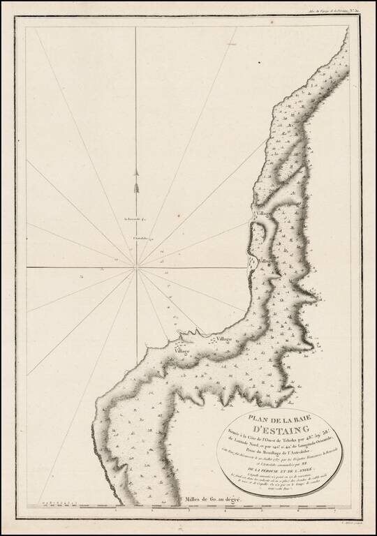
Detailed plan of the Uglegorsk Region, from first official account of the Voyage of La Perouse.


Special conditions for students!

If you are a student, write to us in telegram: @antiquemaps and indicate what material you need and for what work you need a map in high detail. We are ready to provide material on special terms. For students only!

Item information:

Year of creation:
Size:
2891x4108 px
Disk:
1.62012MiB
Number of pages:
1
Place:
Paris
Author:
Jean Francois Galaup de La Perouse.
$14.99

Related item