Map size in jpg-format: 24.4548MiB
Click to open in high resolution (open in new tab).
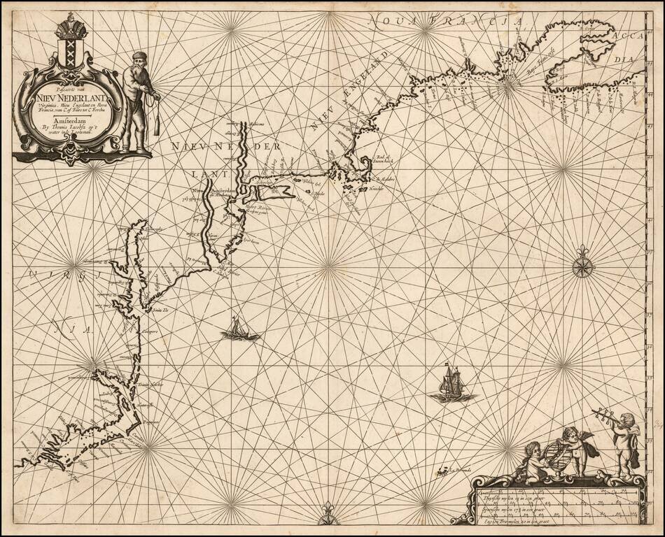
The First Dutch Sea Chart of The East Coast of North America
Rare Dutch Sea Chart, extending from the Outer Banks of the Carolinas to Nova Scotia, first published in about 1650.
There has been significant controversy over the dating of this map. The great Dutch Antiquarian, Frederick Muller, listed the map in his 1891 Catalog as having been published "around 1638."
896. Pascaerte van Nieu Nederlant, Virginies, Nieu Eugelant en Nova Francia, van C. of Faire tot C. Forchu. Amsterdam, Thennis Jacohsz, vers 1638. roy. folio. 7.50
Une des premières cartes de la Nouvelle Néerlande. Le cartouche porte l'écusson d'Amsterdam. Coloriée et rehaussée d'or.
Suarez, in his work Shedding the Veil, (Map 52) notes that "the geography of the map supports the theory that it was prepared . . . no later than 1650 . . ." As noted by Phillip Burden:
This Chart by Theunis Jacobsz was most probably engraved close to his death in 1650. Precisely when is not known, but the author believes that it is due the title of the first Dutch sea chart of New Netherlands, often taken by Arnold Colom['s chart of ] 1656. Following his death the the business was continued by his widow, Lijntje, until his sons, Caspar and Jacob, could take over. At least two atlases of this period are known bearing a small selection of maps by both Jacobsz and the young Frederick de Wit; they can be dated to c. 1653-54. This map is found in both, corroborating its existence by at least that date. Although most probably drawn by Jacobsz before his death, it could have been engraved after it.
The map's coverage is derived from Joannes Janssonius' Nova Anglia Novum Belgium . . . , of 1636, but here it becomes a sea chart. The nomenclature is generally followed along the coast with the notable exception of the Delaware River. Here Jacobsz introduces amongst other F. Nassau, laying the Dutch claim to the river that the Swedish had recently colonized themselves.
The present example of the chart is the second state. The two states are differentiated by Burden as follows:
Rarity
We note two examples appearing at auction in the past 50 years, Sothebys 1981 (1681 ed) and Old World Auctions 2006 (1650).
Provenance: Swann Galleries, December 5, 2017 (deaccessioned from Colonial Williamsburg).
If you are a student, write to us in telegram: @antiquemaps and indicate what material you need and for what work you need a map in high detail. We are ready to provide material on special terms. For students only!
![[The First Maps in a la poupée Printed Color] Cartes en Couleur des Lieux Sujets aux tremblements de Terre Dans toutes les parties du Monde Selon le Sisteme de l’impulsion Solaire](/map/small/52293op.jpg)

