logo

1752. Partie Septentrionale De La Couronne De Castille ou se trouvent Les Royaumes De Castille Vielle De Leon, De Gallice, Des Asturies, La Biscaye Et La Navarre, en Partie . . . 1752

  • Partie Septentrionale De La Couronne De Castille ou se trouvent Les Royaumes De Castille Vielle De Leon, De Gallice, Des Asturies, La Biscaye Et La Navarre, en Partie .  .  . 1752

Partie Septentrionale De La Couronne De Castille ou se trouvent Les Royaumes De Castille Vielle De Leon, De Gallice, Des Asturies, La Biscaye Et La Navarre, en Partie . . . 1752 information:

Year of creation: 
Resolution size (pixels): 
 15557x12959 px
Disk Size: 
 31.5906MiB
Number of pages: 
 1
Place: 
 Paris

Print information. Print size (Width x height in inches):
Printing at 72 dpi 
  216.07 х 179.99
Printing at 150 dpi 
 103.71 х 86.39
Printing at 300 dpi 
 51.86 х 43.2

An example of detailing the file of this map of in a printable high-resolution:

Click to open in high resolution (open in new tab).
Attention! this is just the central piece (central area 960x960 px) of the map file!
This is an example, so that you can see and study the level of detail of a given map. The entire Map will be fully available after payment!

Partie Septentrionale De La Couronne De Castille ou se trouvent Les Royaumes De Castille Vielle De Leon, De Gallice, Des Asturies, La Biscaye Et La Navarre, en Partie .  .  . 1752

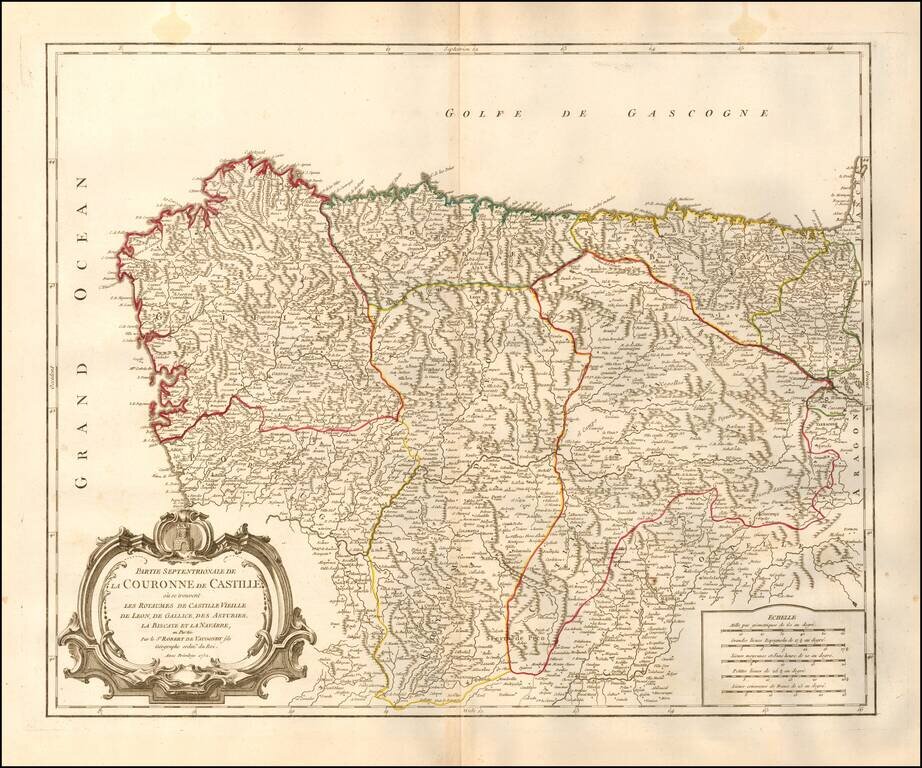
Decorative and highly detailed map of Northwestern Spain, including Biscaya, Gallicia, Leon, Asturias, Old Castille, and New Castille.

A finely detailed map, with decorative cartouche.

Gilles Robert de Vaugondy (1688-1766) was the head of a leading family of geographers in eighteenth century France. Gilles got his start when he jointly inherited the shop of Pierre-Moullart Sanson, grandson of the famous geographer Nicholas Sanson. The inheritance included the business, its stock of plates, and a roller press. In 1760 Gilles became geographer to King Louis XV. His son, Didier Robert de Vaugondy (ca. 1723-1786), was also a geographer and the two worked together. They were known for their exactitude and depth of research. In 1757, they produced the Atlas Universel, considered an authority for many years.


Special conditions for students!

If you are a student, write to us in telegram: @antiquemaps and indicate what material you need and for what work you need a map in high detail. We are ready to provide material on special terms. For students only!

Item information:

Year of creation:
Size:
15557x12959 px
Disk:
31.5906MiB
Number of pages:
1
Place:
Paris
Author:
Gilles Robert de Vaugondy.
$14.99

Related item