logo

1778. Partie Occidentale De L'Empire De Russie Contenant les Provinces de Berezowskoy, Mangajeskoy,Wiatka, Solkamskoy, Pelymskoy, Usimoskoy, Tobolskoy, Surgutskoy, Jenifeiskoy, Narimskoy, Kuzneckoy, Tomskoy, Drasnojarskoy &c., le Royaume de Kasan, Le Gouverneme

  • Partie Occidentale De L'Empire De Russie Contenant les Provinces de Berezowskoy, Mangajeskoy,Wiatka, Solkamskoy, Pelymskoy, Usimoskoy, Tobolskoy, Surgutskoy, Jenifeiskoy, Narimskoy, Kuzneckoy, Tomskoy, Drasnojarskoy &c., le Royaume de Kasan, Le Gouverneme

Partie Occidentale De L'Empire De Russie Contenant les Provinces de Berezowskoy, Mangajeskoy,Wiatka, Solkamskoy, Pelymskoy, Usimoskoy, Tobolskoy, Surgutskoy, Jenifeiskoy, Narimskoy, Kuzneckoy, Tomskoy, Drasnojarskoy &c., le Royaume de Kasan, Le Gouverneme information:

Year of creation: 
Resolution size (pixels): 
 14790x12043 px
Disk Size: 
 33.3405MiB
Number of pages: 
 1
Place: 
 Venice
Author: 

Print information. Print size (Width x height in inches):
Printing at 72 dpi 
  205.42 х 167.26
Printing at 150 dpi 
 98.6 х 80.29
Printing at 300 dpi 
 49.3 х 40.14

An example of detailing the file of this map of in a printable high-resolution:

Click to open in high resolution (open in new tab).
Attention! this is just the central piece (central area 960x960 px) of the map file!
This is an example, so that you can see and study the level of detail of a given map. The entire Map will be fully available after payment!

Partie Occidentale De L'Empire De Russie Contenant les Provinces de Berezowskoy, Mangajeskoy,Wiatka, Solkamskoy, Pelymskoy, Usimoskoy, Tobolskoy, Surgutskoy, Jenifeiskoy, Narimskoy, Kuzneckoy, Tomskoy, Drasnojarskoy &c., le Royaume de Kasan, Le Gouverneme

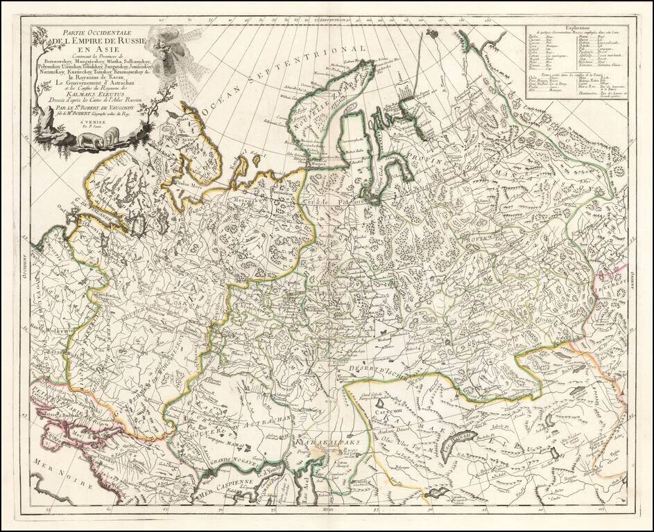
Highly detailed map of the Western Part of Russia, extending South to the Caspian and East to Irkurkoy and Ilimskoy.

The map is drawn from the Atlas of Russia compiled under the direction of Joseph Nicolas De L'Isle in St. Petersburg.

Paolo Santini (1729-1793) was an Venetian engraver known especially for his religious prints and fine cartographic engravings. He published in Venice and may have a been a member of the clergy. In his maps, he largely adopted and adapted the work of his French counterparts, especially the brothers de Vaugondy.


Special conditions for students!

If you are a student, write to us in telegram: @antiquemaps and indicate what material you need and for what work you need a map in high detail. We are ready to provide material on special terms. For students only!

Item information:

Year of creation:
Size:
14790x12043 px
Disk:
33.3405MiB
Number of pages:
1
Place:
Venice
Author:
Paolo Santini.
$14.99

Related item