logo

1774. Partie Du Nord De L'Amerique Septentrional Pour Servir A L'Histoire Philosophique et Politique . . .

  • Partie Du Nord De L'Amerique Septentrional Pour Servir A L'Histoire Philosophique et Politique . . .

Partie Du Nord De L'Amerique Septentrional Pour Servir A L'Histoire Philosophique et Politique . . . information:

Year of creation: 
Resolution size (pixels): 
 5796x8088 px
Disk Size: 
 12.0532MiB
Number of pages: 
 1
Place: 
 Paris
Author: 

Print information. Print size (Width x height in inches):
Printing at 72 dpi 
  80.5 х 112.33
Printing at 150 dpi 
 38.64 х 53.92
Printing at 300 dpi 
 19.32 х 26.96

An example of detailing the file of this map of in a printable high-resolution:

Click to open in high resolution (open in new tab).
Attention! this is just the central piece (central area 960x960 px) of the map file!
This is an example, so that you can see and study the level of detail of a given map. The entire Map will be fully available after payment!

Partie Du Nord De L'Amerique Septentrional Pour Servir A L'Histoire Philosophique et Politique . . .

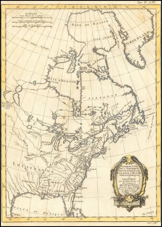
Decorative map of North America, published in 1774.

The map extends west to include Texas and much of the supposed course of the Missouri, north to a mythical set of lakes referenced as the supposed location of the Sea of the West.

Includes Indian Place names and several early French forts west of the Appalachians, along with a number of early placenames in the South and near the Great Lakes, including Toronto and Detroit.


Special conditions for students!

If you are a student, write to us in telegram: @antiquemaps and indicate what material you need and for what work you need a map in high detail. We are ready to provide material on special terms. For students only!

Item information:

Year of creation:
Size:
5796x8088 px
Disk:
12.0532MiB
Number of pages:
1
Place:
Paris
Author:
Rigobert Bonne.
$14.99

Related item