Map size in jpg-format: 133.508MiB
Click to open in high resolution (open in new tab).

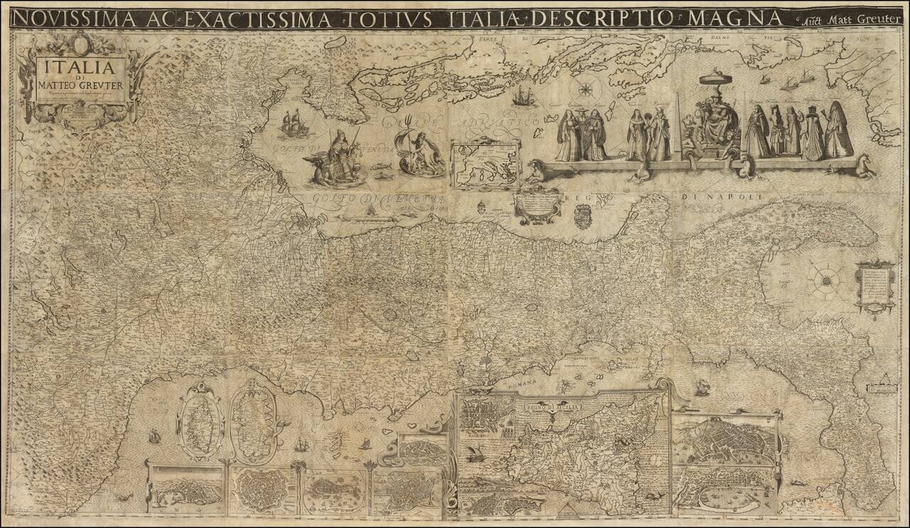
A Landmark Seventeenth-Century Wall Map of Italy
Spectacular 12-sheet map of Italy, first published by Matteo Greuter in Rome in 1630 and offered here in its second publication, by Stefano Scolari in Venice in 1657.
At the time of its publication, the map was the largest map of Italy ever published. This is the only known example to include the title above the map with white letters on a black background, an unusual and visually charming element.
Another visually arresting element of the map is the depiction of Italy on its side. The map is oriented with northeast at the top. The map notes, "Questo Geografico Disegno è Voltato à traverso per la Comodità del Lettore.” In English, “This geographical design is turned sideways for the comfort of the reader...”
The map is thick with geographic content. Hundreds of villages and towns cover the interior. These are not denoted by a single symbol, but with numerous signs showing the size and type of church the locale has, the size of the settlement, and other details. Some have coats of arms included as well. Dotted lines separate political entities. Certain cities have recognizable features, including St. Peter’s Basilica and the city walls of Rome. Hills and mountains are also marked, some with unique features like a gaping hole, as it in the case of volcanic Mount Vesuvius near Naples.
The longitudes shown are relative to the Cape Verde islands and the place names are in Italian. The three major islands of Sicily, Sardinia, and Corsica are shown separately as insets. Views of major Italian cities are also shown, including Genoa, Milan, Venice, Rome, Florence, Palermo, Syracuse, Catania, Naples and Messina. There is also an inset map of Europe in the Adriatic Sea.
In the Gulf of Venice, a hand emerges from the waves to point to a scale in Venetian miles. It is protected by a Venetian vessel and menaced by a hungry sea-bear. Just below the main allegorical vignette (discussed below) is a cartouche with the twelve southern provinces of the Kingdom of Napoli. This cartouche is flanked by coats of arms. Many ships are adrift in the waters all around Italy.
In the Mediterranean, to the south of the peninsula, a cartouche houses a brief text explaining the orientation of the map. The decorative but not ostentatious strapwork on this cartouche is echoed in the title cartouche in the upper left, as well as in the inset maps and views below. There is also a compass rose with the directional winds labeled. Slightly farther east is another scale measuring twelve miles and topped with dividers.
The title cartouche contains a dedication to Signore Gioseppe Sauoldo, a judge of the College of Brescia. Brescia, a province and city in Lombardy, was then under Venetian rule. Sauoldo is also the consigliere, or advisor, to the Elector and Duke of Bavaria. In 1657, when the map was reissued, this was Ferdinand Maria, who ruled Bavaria from 1651 to 1679. Ferdinand needed the advice of men like Sauoldo, for he was only 15 when he ascended to the position of Elector. He was officially crowned in 1654 and is known for modernizing the Bavarian army and introducing the first Bavarian local governmental code.
Greuter's map of Italy must have been popular, as it was reissued several times over the course of nearly two centuries. First, it was re-released in Venice by Stefano Scolari in 1657; then, by Pietro Todeschi and Giuseppe Longhi in Bologna in 1676; and then, by Domenico De Rossi in Rome in 1695. Finally, Todeschi and Longhi released another example in 1713.
Allegorical features
The rich allegorical figures at the top right are yet another visual treat of this map. These center around a female representation of Italy, seated on the throne, with the Po and Tiber rivers at her feet. On either side are the trappings of civilization, including armor, a vase, an artist cherub, musical instruments, and crowns. To the left and right, Italy is flanked by five costumed ladies representing the various Italian provinces. They are opulently dressed, showing the diversity and prosperity of the Italian peninsula.
To the left of these women is Poseidon with his trident. Next to this is another allegorical figure, a regal woman draped in ermine and sumptuous clothes. She holds the scales of justice and a sword. Next to her on the decorative shell in which she floats is a lion holding a book which proclaims, “Pax Tibi Marce Evangelista Meus.” This is the symbol of the Republic of Venice, which was thriving when this map was published there. Venice took as their patron saint St. Mark the Evangelist, who is supposed to have written the gospel of Mark. The most famous church of the city is the Cathedral Basilica of St. Mark, originally the chapel of the powerful Doge, or ruler, of Venice.
St. Mark’s symbol, the lion, also represented the power of Venice as a trading state. Venetian nobility would keep lions in their gardens and there was an official state lion held captive in the Piazza San Marco. Lions were then banned after this official lion died, most likely from poison ingested by licking the gilded bars of his cage. Traditionally, and as seen on this map, the lion is shown on or near water, symbolizing Venice’s dominance of the seas and maritime commerce.
Rarity
The original Rome edition of the Greuter does not survive, but two later states are known: a 1640 (Bibliotheque National de France) and a 1647 (Mediateca di Santa Teresa di Milano).
The Scolari Venice edition of the map survives in very few recorded examples. These include examples in the Biblioteca Nazionale di Firenze (Fondo Palatino) and the Bibliothèque Nationale de France. There is also a privately-owned example in Rome, in the collection of Stefano Bifolco.
If you are a student, write to us in telegram: @antiquemaps and indicate what material you need and for what work you need a map in high detail. We are ready to provide material on special terms. For students only!


