Map size in jpg-format: 39.385MiB
Click to open in high resolution (open in new tab).
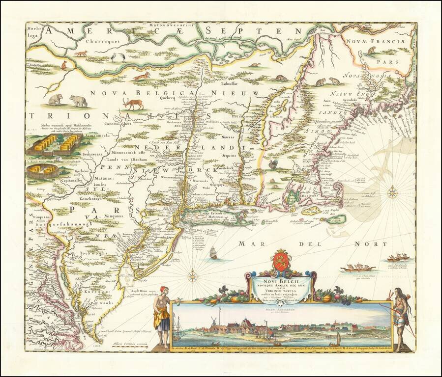
Visscher's Landmark Map of the Northeast -- Early View of New York City
Finely colored example of Nicolaes Visscher's important map of the Northeast, with a large inset view of New York City.
This is the first map containing the famous inset view of New Amsterdam, the third known engraved view of New York. Manhattan is correctly shown as an island and has its settlement at the southern end clearly marked. The publication of the map was motivated by the recent establishment of a Dutch Colony in the New World and Dutch aspirations to retain their New Netherland colony. As such, its advanced geography, based on the 1651 map of Jansson, was of paramount importance to the colony, which needed to make plainly known its vulnerability to English attack. British settlements and Indian villages are recorded, and vignettes illustrate fauna and Indian fortifications.
Visscher's map of the Northeast is among the sought after regional maps. In 1655, Visscher utilized Jansson's map, with its vignettes of animals and Indian life and added this now-famous view of New Amsterdam, showing the Battery and Dutch buildings on the waterfront. An extensive study of the map by Stokes suggests that the view was drawn sometime between 1653 and 1655, prior to the construction of New York's wall. The first edition of the map (1655-56) is extremely rare and known in only a handful of copies, one of which was used to illustrate the boundary dispute between William Penn and Lord Baltimore.
The map is also of great importance as the only reasonably obtainable example of the map during the first Dutch Colonization of the region, prior to their defeat by the English.
The states of the map are as follows:
If you are a student, write to us in telegram: @antiquemaps and indicate what material you need and for what work you need a map in high detail. We are ready to provide material on special terms. For students only!
![[The First Maps in a la poupée Printed Color] Cartes en Couleur des Lieux Sujets aux tremblements de Terre Dans toutes les parties du Monde Selon le Sisteme de l’impulsion Solaire](/map/small/52293op.jpg)

