Map size in jpg-format: 16.9875MiB
Click to open in high resolution (open in new tab).
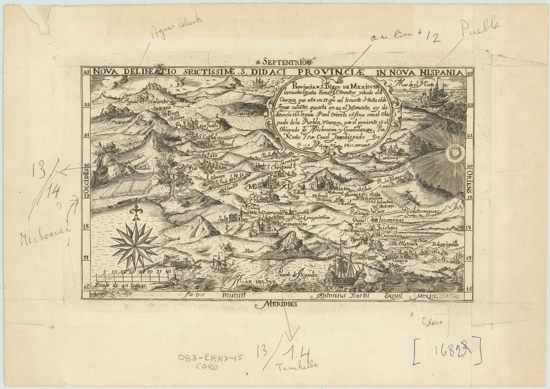
Fascinating later printing of the second state of "one of the first copper-engraved maps published in Mexico (the map that appeared in Montemayor y Cuenca's Discurso politico, historico, jurídico del derecho, (1658) is earlier (from Ken Ward, JCB)" - Rumsey 8639
David Rumsey (8639) summarizes the content of the map:
The map is centered on Mexico City and presents a bird's-eye view of central Mexico extending from the Gulf of Mexico to the Pacific Ocean. The region is known as the ecclesiastical province of San Diego, and extends from Aguascalientes and Guanajuato in the north to Acapulco and Oaxaca in the south. The title cartouche mentions 12 convents in the region, which are depicted on the map. The map is handsomely embellished with a rising sun, several sailing ships, a compass rose, and even birds flying above in the sky. The map was engraved by the highly skilled Antonio Ysarti for publication in Baltasar de Medina's Chronica de la Santa Provincia de San Diego de Mexico. Little is known about Ysarti, who also engraved a remarkable frontispiece for Medina's book, depicting numerous Franciscan martyrs within a Franciscan temple. Friar Baltasar de Medina was born in Mexico and became a Discalced Franciscan, a separate order of Franciscans that remain barefoot. Medina was named the official chronicler for the Discalceds, and in 1682 he published a history of the order's accomplishments in his masterwork Chronica, which focused on both Franciscan martyrs and colonial life in New Spain. Ysarti's map was the only one to be included in the Chronica. This scarce map is an important milestone in Mexican cartography and the history of the Americas. The Library of Congress holds the revised copperplate of the map, which mentions 14 convents with Valladolid added at center left and has the date removed from the bottom border.
Later State and Printing
The BnF has an example of the later impression, for which they provide the following note:
Figuration des 14 couvents de la province. XVIIe s. Tirage moderne par Frelaut d'un cuivre ancien.
The entry indicates that the map was printed in 1971 by the famous Parisian print publishers Atelier Lacourière-Frélaut, which provides some insight into the publication history of this unusual second state. The printing plate was later acquired by the Library of Congress, where it now is held.
This example would appear to be a working proof of that later printing, with numerous pen and pencil markings highlighting the changes between this state of the map and the first state. Interestingly, the print quality is much better with this example than with many examples of the earlier state of the map.
If you are a student, write to us in telegram: @antiquemaps and indicate what material you need and for what work you need a map in high detail. We are ready to provide material on special terms. For students only!


![Map of Mexico, Central America, and the West Indies [Insets of Bermuda, Sandwich Islands, Jamaica and Panama Railroad]](/map/small/69133.jpg)