logo

1808. New South Wales, New Zealand, New Hebrides and the Islands Adjacent, comprising the Discoveries of Mendana, Qurios, Carteret, Bougainville, Surveille, Cook, Shortland, &c . . . 1808

  • New South Wales, New Zealand, New Hebrides and the Islands Adjacent, comprising the Discoveries of Mendana, Qurios, Carteret, Bougainville, Surveille, Cook, Shortland, &c . . . 1808

New South Wales, New Zealand, New Hebrides and the Islands Adjacent, comprising the Discoveries of Mendana, Qurios, Carteret, Bougainville, Surveille, Cook, Shortland, &c . . . 1808 information:

Year of creation: 
Resolution size (pixels): 
 5879x7438 px
Disk Size: 
 9.36091MiB
Number of pages: 
 1
Place: 
 London
Author: 

Print information. Print size (Width x height in inches):
Printing at 72 dpi 
  81.65 х 103.31
Printing at 150 dpi 
 39.19 х 49.59
Printing at 300 dpi 
 19.6 х 24.79

An example of detailing the file of this map of in a printable high-resolution:

Click to open in high resolution (open in new tab).
Attention! this is just the central piece (central area 960x960 px) of the map file!
This is an example, so that you can see and study the level of detail of a given map. The entire Map will be fully available after payment!

New South Wales, New Zealand, New Hebrides and the Islands Adjacent, comprising the Discoveries of Mendana, Qurios, Carteret, Bougainville, Surveille, Cook, Shortland, &c . . . 1808

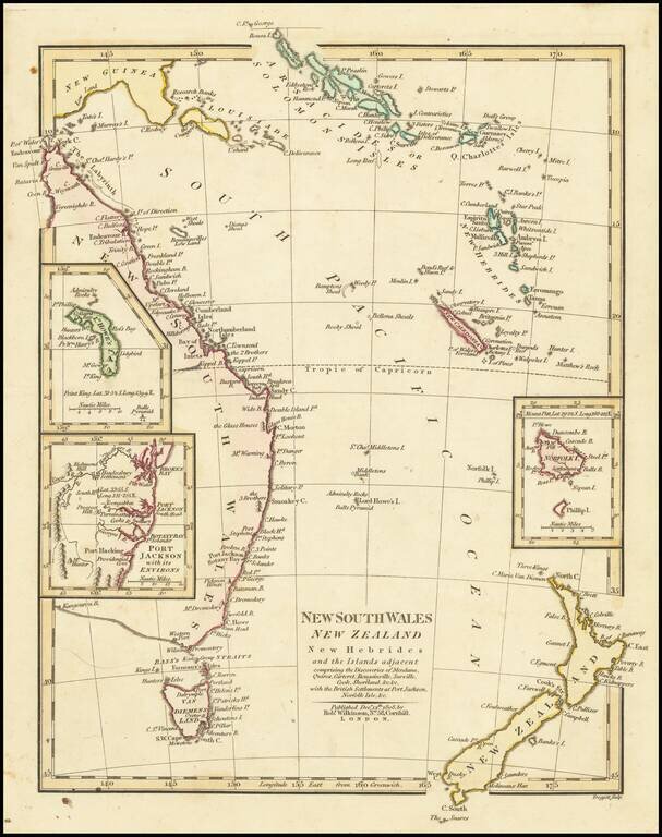
Interesting regional map of Eastern Australia and New Zealand, published by Robert Wilkinson.

The map extends from the Solomon and Queen Charlotte Island in the North to New South Wales and New Zealand. Includes large insets of L. Howes and Norfolk areas and Port Jackson. An interesting and detailed coastal chart during the early era of discovery in these regions.

Robert Wilkinson was active in London as a cartographic publisher from 1785 to 1825. He produced a number of nice works, including a General Atlas and a re-issuance of Bowen & Kitchen's English Atlas, along with excellent large format separate maps.


Special conditions for students!

If you are a student, write to us in telegram: @antiquemaps and indicate what material you need and for what work you need a map in high detail. We are ready to provide material on special terms. For students only!

Item information:

Year of creation:
Size:
5879x7438 px
Disk:
9.36091MiB
Number of pages:
1
Place:
London
Author:
Robert Wilkinson.
$14.99

Related item