logo

1877. New Map of the Territory of Arizona Southern California and Parts of Nevada, Utah and Sonora Compiled from the latest authentic data by Lietenant J.C. Mallery, A.M., US. Engineers Corps, and J.W. Ward, Civil & Topographical Engineer. 1876-77

  • New Map of the Territory of Arizona Southern California and Parts of Nevada, Utah and Sonora Compiled from the latest authentic data by Lietenant J.C. Mallery, A.M., US. Engineers Corps, and J.W. Ward, Civil & Topographical Engineer.  1876-77

New Map of the Territory of Arizona Southern California and Parts of Nevada, Utah and Sonora Compiled from the latest authentic data by Lietenant J.C. Mallery, A.M., US. Engineers Corps, and J.W. Ward, Civil & Topographical Engineer. 1876-77 information:

Year of creation: 
Resolution size (pixels): 
 20930x26506 px
Disk Size: 
 120.258MiB
Number of pages: 
 1
Place: 
 San Francisco
Author: 

Print information. Print size (Width x height in inches):
Printing at 72 dpi 
  290.69 х 368.14
Printing at 150 dpi 
 139.53 х 176.71
Printing at 300 dpi 
 69.77 х 88.35

An example of detailing the file of this map of in a printable high-resolution:

Click to open in high resolution (open in new tab).
Attention! this is just the central piece (central area 960x960 px) of the map file!
This is an example, so that you can see and study the level of detail of a given map. The entire Map will be fully available after payment!

New Map of the Territory of Arizona Southern California and Parts of Nevada, Utah and Sonora Compiled from the latest authentic data by Lietenant J.C. Mallery, A.M., US. Engineers Corps, and J.W. Ward, Civil & Topographical Engineer.  1876-77

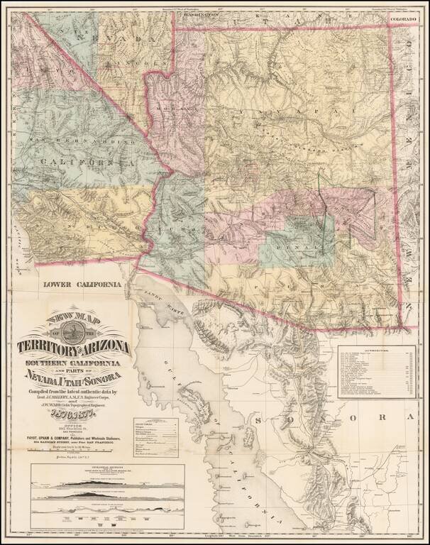
The Finest Large Format Map of Arizona, Southern California and Southern Nevada from the 1870s.

Large and striking map centered on Arizona with pieces of the adjacent states and territories, at a time when Arizona was undergoing a mineral boom, and the unavoidable conflict of ranchers, miners, Indians and outlaws.

Rumsey notes:

Based on the War Department Maps of the same area . . . . Wheat dates this map 1876 because that is the copyright date. Wheat says that "enough detail is provided in every part of the map to keep a platoon of historians happy for weeks." Has a list of 25 authorities and show Geological Sections based on Wheeler's surveys of 1875.

Warren Heckrotte comments that "Mallery was responsible for an earlier map of Arizona: Department of Arizona. Revised 1875. Office of the Chief of Engineers, U.S. Army, Washington, D.C. 1876. First Lieut. J.C. Mallery, Corps of Engineers, Chief Engineer. Under the authority of Major General J.M. Schofield.

Rarity

The map is exceedingly rare. This is the first example we have ever seen on the market and the only example to appear at auction per RBH.

Provenance: Warren Heckrotte Sale, PBA Galleries December 3, 2015.

Wheat TW 1272.

Special conditions for students!

If you are a student, write to us in telegram: @antiquemaps and indicate what material you need and for what work you need a map in high detail. We are ready to provide material on special terms. For students only!

Item information:

Year of creation:
Size:
20930x26506 px
Disk:
120.258MiB
Number of pages:
1
Place:
San Francisco
Author:
J.C. Mallery. J.W. Ward.
$21.99

Related item