Map size in jpg-format: 89.8465MiB
Click to open in high resolution (open in new tab).
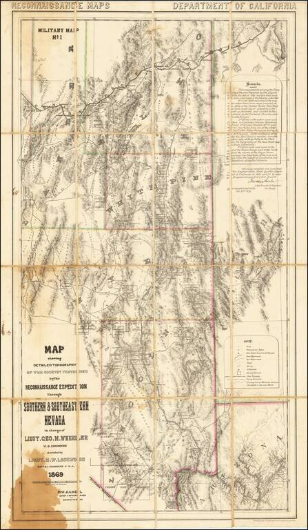
A Nevada & Grand Canyon Rarity -- The Foundation Map for Southern Nevada
A remarkable map of the Eastern Half of Nevada, including Las Vegas, the Grand Canyon, Great Salt Lake and Sevier Lake (then called Preuss Lake), being the first scientific mapping of the region and Geore M. Wheeler's first printed map.
Thomas Streeter noted: "Since Wheeler's exploration was in part over country never before mapped, this as far as I know, is the foundation map for southern Nevada."
The map extends from the area around Las Vegas and the Grand Canyon in the south to the Great Salt Lake, Humboldt Wells and the Line of the Union Pacific Railroad across the northern Nevada. The map is richly illustrated with mining districts shown, wagon roads, trails, springs, settlements, county and state boundaries, etc.
This would appear to be part of the genre of maps compiled in the various Military Departments in the Western United States, which were intended primarly for distribution among field officers (and not for general dissemination or sale), with the intent that the maps be used, annotated and periodically updated within each of the military departments at the discretion of the commanding officers. In fact, the map notes that it is "Reconnaissance Maps Department of California Military Map No. 1", which is likely reflective of the prospect that the Department of California was potentially undertaking other Reconnaissance Maps, although we cannot locate another map produced by the Department of California..
As noted by David Rumsey:
1st Wheeler map, done before 100th Mer. Survey. Streeter: "Since Wheeler's exploration was in part over country never before mapped, this as far as I know, is the foundation map for southern Nevada." Above the neat line reads "Reconnaissance Maps. Department Of California." Unfolded separate issue. Outline color by county.The map includes a lengthy remark, which states:
This map presents not only the Topography of the area traverse by the Expedition in the fall of 1869 but also that from the notes and maps of the following authorities 1st On the north west corner of the map information taken from maps compiled at the office of the Central Pacific Railroad has been made use of extending as far south as Belmont and limited to the eastward by the Diamond, Pancake and Reveille Ranges. 2nd At the north eastern corner such portion is included between Meridans 114° and 115° 20' and Paralells (sic) 39°55 and 40° 25', was tekn from one of the sheets of the United States Geological survey of the 40th Paralell (sic). To the northward of this unitl the Rail Road is reached from the eastern side of the Ruby Valley to the Utah LIne the topography of the Rail Road map has been introduced. 3rd. At the south east corner to the east of the Virgin Range and to the south east of the mouth of the Virgin River, advantage has been taken of the map compiled from the results of Lieutenant Ives' explorations along the Colorado. Officially compiled and published at the Engineer Office, Head Quarters Department of the California in 1869 and 1870 by order of Brigadier General E.O. C. Orde Comm'dg Geo. M. Wheeler Lieutenant of Engineers in Chartg Head Quarters Dept. of Cal. Oct. 26, 1870.George Wheeler
Wheeler's first assignment after graduation was to the Corps of Engineers in California. In September, 1868, he was made engineer on the staff of the commanding general of the Department of California. In the late spring of 1869 he was ordered to make a reconnaissance of the area southeast of the White Pine Mines to the northernmost navigable point of the Colorado River, in order to establish a wagon road from the White Pine or Grant Mining District. In furtherance of this task, he was to create a military map of the region and select sites for military posts to protect these mining regions from hostile Indians. Wheeler notes, "that his report was printed at San Francisco in 1869, in a folio pamphlet, accompanied by a topographical map, separately issued, on a scale of 1 inch to 12 miles." The report, with additions but without the map, was reprinted at Washington in 1875. During his reconnaissance, Wheeler visited 18 mining districts, discovered that Preuss Lake was Sevier Lake, and found the Colorado to be navigable at all seasons as far as the Grand Canyon region. Rarity
This is the second example of the map we have seen in the past 25 years.
If you are a student, write to us in telegram: @antiquemaps and indicate what material you need and for what work you need a map in high detail. We are ready to provide material on special terms. For students only!

![Mexique par Th. Duvotenay…1843 [Republic of Texas]](/map/small/67925.jpg)
