Map size in jpg-format: 74.4435MiB
Click to open in high resolution (open in new tab).
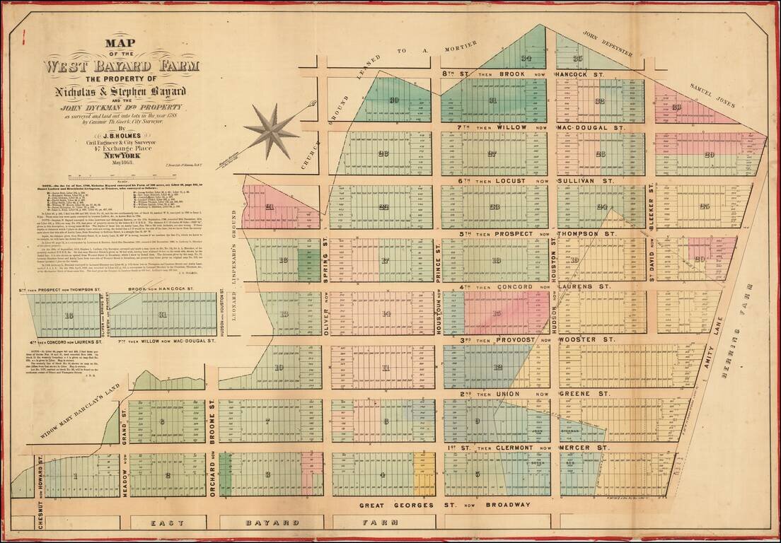
Antique Map of Soho, New York City.
Superb large format, separately issued map of Soho in Manhattan, by one of New York's most fascinating mapmakers, John Bute Holmes.
The map covers the exclusive retail and residential neighborhood of Soho, bounded by Broadway at the bottom, Bleeker at the right, Hancock (no longer extant) at the top, and Howard at the left. The map is oriented with west at the top. Interestingly, Holmes bases his north indicator on the 1788 magnetic meridian - indicating his reliance on original manuscript surveys.
Bayard Farm
The map shows the 100-acre farm of Nicholas and Stephen Bayard, which was in their family in the 17th century. As noted on the map, the land passed to Daniel Ludlow and Brockholst Livingston, as trustees, in 1789, they conveyed the land to several individuals (Aaron Burr among them).
The present map covers the west section of the farm; Holmes made an accompanying map of the east section, which we have also handled, as part of the same collection.
Provenance
This map was acquired as a part of a large collection of New York cadastral maps associated with the layer Ronald K. Brown, a Deed Commissioner operating in the late 19th and early 20th century with an office at 76 Nassau Street, New York - not far from Holmes' own office. Most of the maps in the collection, including the present map, bear Brown's stamp on the verso. The maps were passed to Dominic Anthony Trotta, a real estate agent working under Brown. Brown seems to have ceased business around 1919, but Trotta continued as a real estate agent, becoming a New York Tax Commissioner in 1934 under the Fiorello H. La Guardia administration. The maps remained with Trotta's heirs until our acquisition of the collection.
Publication History and Census
Holmes based this map on the survey work of Casimir T. Goerk, the famed city surveyor behind the Commissioners Plan. It was engraved by Thomas Bonar, Nassau Street. The map exists in only one edition, as here, published in 1868. It is of considerable rarity. The OCLC identifies only 2 examples: at Princeton and the New York State Library. New York Public Library has an uncatalogued example. There is at least one other example in private hands.
If you are a student, write to us in telegram: @antiquemaps and indicate what material you need and for what work you need a map in high detail. We are ready to provide material on special terms. For students only!

![[Charles Lindbergh] Spirit of St. Louis](/map/small/69234.jpg)
![[Charles Lindbergh / New York to Paris View] Spirit of St. Louis](/map/small/69235.jpg)