City Surveyor John Bute Holmes (ca.1820-1887) was a compelling figure, as much for his scandalous personal life, as for his ingenious maps.
The details of his early personal life are difficult to trace, partially as he constantly changed his version of his biography. At one point he claimed to have been born on the Island of Mauritius in 1822, and to have moved from there to Cork, Ireland; according to his account, he moved from Cork to the United States in 1838. He held the position of City Surveyor in New York in the 1860s through 1880s and eventually settled on a farm in New Jersey, where he died.
According to the cataloging of Lindsay Turley, of the Museum of the City of New York:
John Bute Holmes was married to at least four women during his life, sued by a fifth for "impeaching her chastity" as a result of "breach of promise of marriage," known to have lived with another "as husband and wife," and was reputed to have killed a policeman with whose wife he was involved. Some of these relationships appear to have overlapped, and most of the wives were unaware of the previous wives, even when the unions had been dissolved legally. It wasn't until Holmes's death in 1887 that the four legal (or at least to their knowledge) wives came face to face in an attempt to claim their inheritance. The dual nature of Holmes's maps strangely seems to reflect the duplicitous nature of Holmes's life...
A few different accounts in the New York Times attempt to sort it out, and briefly, this is what I've come away with:
See the MCNY blog entry on John Bute Holmes here: https://blog.mcny.org/2014/03/04/john-bute-holmes-surveyor-and-polygamist/
Holmes is thought to have produced a total of 21 maps of between the 1860s and the 1880s. We have not completed a total census of all map titles from Holmes' series, but we have handled over a dozen from one collection only.
"Farm Maps"
Although it is now hard to believe, Manhattan, as recently as the early 19th century, was largely covered in open farmland. As the city rapidly developed during the 19th century, all hints of its previous bucolic state fell away. In the 1860s, this transformation became a fascination for City Surveyor John Bute Holmes (about whom, more later).
Holmes began gathering old surveys and documents that related to Manhattan's previous land use and landowners, transposing new lot and street detail over the previous geography.
There was a long history of mapping Manhattan's farms, both during the actual agricultural era and thereafter. One of the greatest cartographic feats was Randel's Farm Maps which are reminiscent of Holmes' without the "modern" overlay. http://www.mcny.org/content/randel-farm-maps
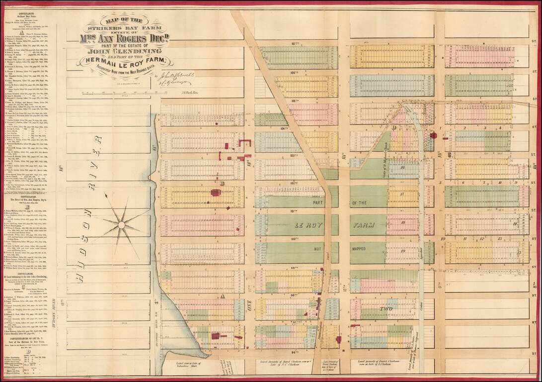
Detailed cadastral map of the Upper West Side, between 96th Street and 109th Street, and present-day Central Park West and the Hudson River. As with his other Manhattan neighborhood maps, Holmes shows old plots, roads, and buildings transposed over...
![[Collect Pond and Tribeca, Manhattan] Map of Property Lying on Each Side of Broadway Formerly Known as the Calk Hook Accurately made from Old Deeds Maps and other Reliable Sources.](/map/small/64190.jpg)
Fascinating map of the Collect Pond, Canal Street, and Tribeca by one of New York's most eccentric mapmakers. Superb large format, separately issued map of part of Tribeca in Manhattan, by one of New York's most fascinating mapmakers, John Bute...
Antique Map of Soho, New York City. Superb large format, separately issued map of Soho in Manhattan, by one of New York's most fascinating mapmakers, John Bute Holmes. The map covers the exclusive retail and residential neighborhood of Soho, bounded...
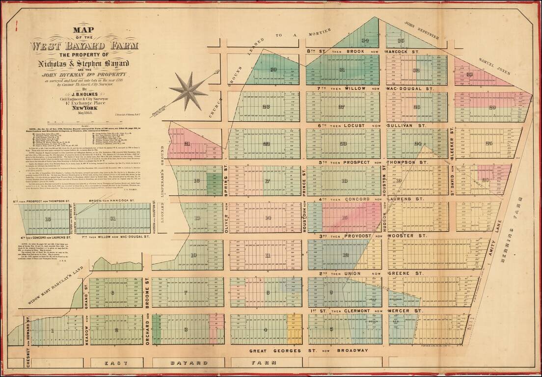
![[Nolita -- Lower Manhattan] Map of Bayard's East Farm, Accurately Made From Old Maps, [not in Register's Office,] From Conveyances on Record from Nicholas Bayard, Sheriffs Sales, Lottery Lots &c. &c.](/map/small/61032.jpg)
Fascinating Historical Map of Nolita, with the area between Prince, Broadway, the Bowery, and Bayard Street. Superb large format, separately issued map of part of Soho in Manhattan, by one of New York's most fascinating mapmakers, John Bute Holmes....
A rare and highly detailed separate issue 1869 John Bute Holmes map of the Chelsea neighborhood of Manhattan, New York City. The map covers from the Hudson River to 7th Avenue and from 19th to 29th street. Like all of Holmes' important neighborhood...
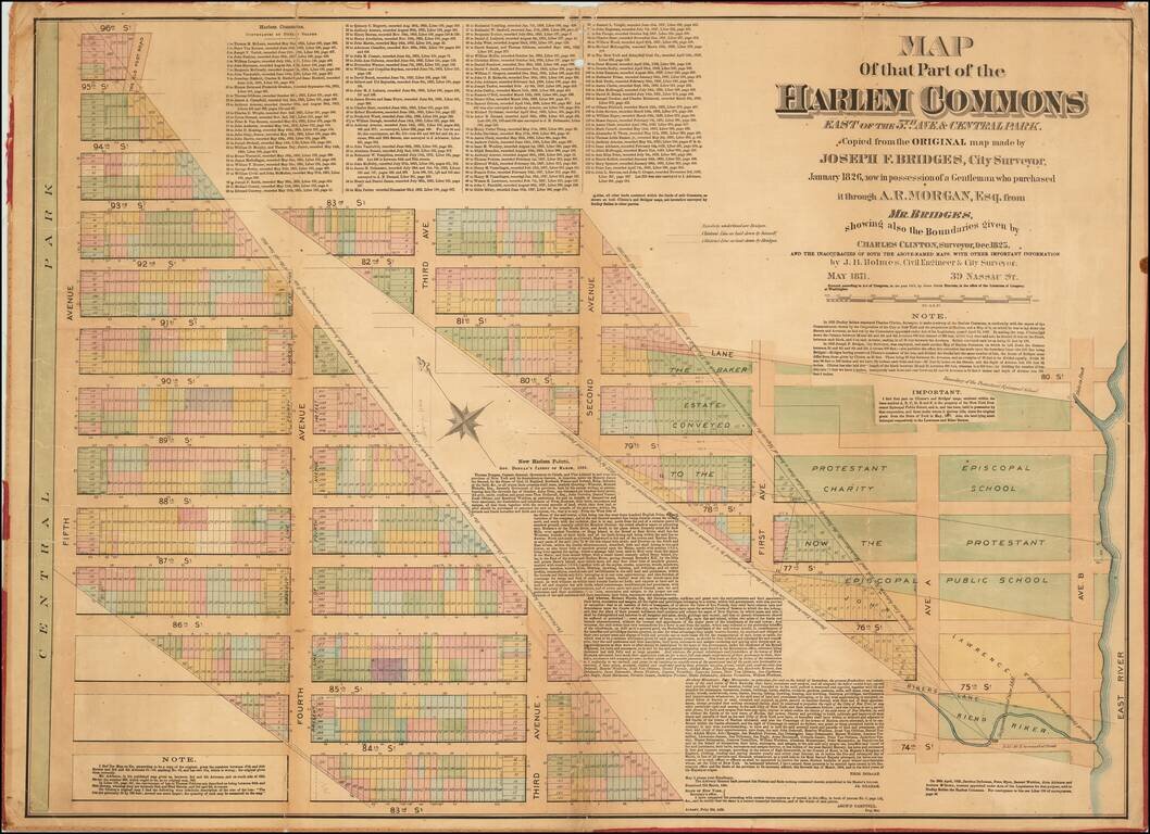
Rare Antique Map of Part of Harlem, New York City. Superb large format, separately issued map of parts of the Upper East Side and Harlem in Manhattan, by one of New York's most fascinating mapmakers, John Bute Holmes. This map shows a strip of land...
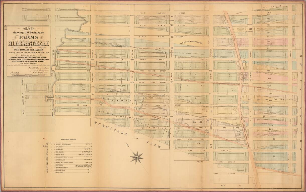
![[Hells Kitchen / Midtown West] Map of the Hermitage Farm and the Norton Estate Compiled From Authentic Data.](/map/small/61035.jpg)
Hells Kitchen / Midtown West 1872 John Bute Holmes cadastral map of the modern-day neighborhood of Hell's Kitchen in the borough of Manhattan in New York City. The map depicts the neighborhood from the Hudson River to Broadway (labeled as...
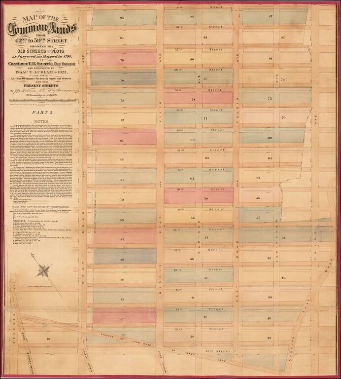
![[Upper East Side - Manhattan -- 79th Street to 93rd Street] Map of the Common Lands from 76th to 93rd Street Showing the Old Streets and Plots As Surveyed and Mapped in 1796, By Cassimer T. H. Goerck, City Surveyor and Resurveyed by Isaac T. Ludlam in 1](/map/small/61033.jpg)
Upper East Side - Manhattan (79th Street to 93rd Street) This is a John Bute Holmes 1874 cadastral map of the Upper East Side neighborhood of Manhattan - the only specific map of this area to appear in the 19th century. The map depicts the region...
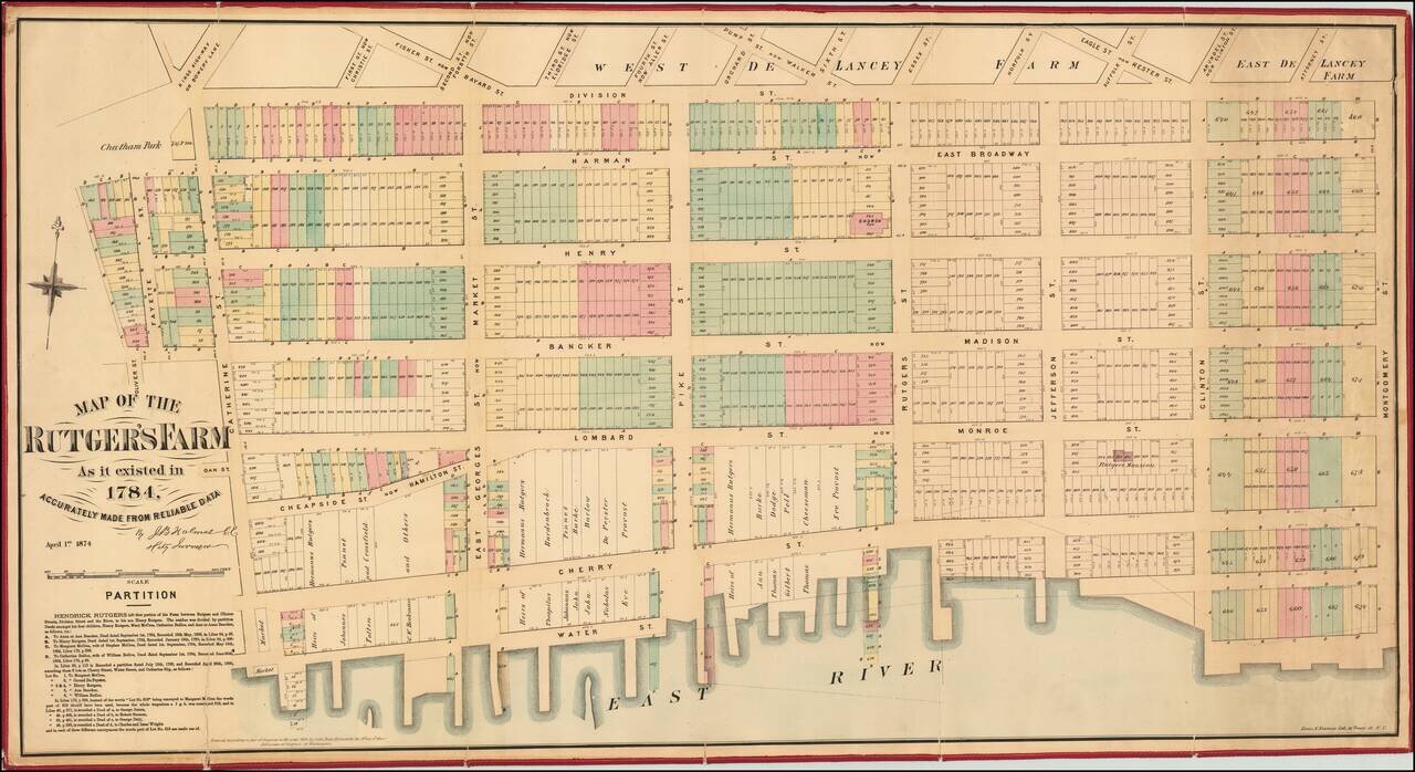
Excellent separately-issued 1874 map of the Lower East Side and Two Bridges neighborhoods of Manhattan. The map covers Oliver Street to Montgomery street and from Division to the East River. The Rutgers Farm The Rutgers Farm, which occupied the...
Fascinating map of the Upper East Side by one of New York's most eccentric mapmakers. Superb large format, separately issued map of part of the Fashion District in Manhattan, by one of New York's most fascinating mapmakers, John Bute Holmes. This...
Rare Cadastral Map of Midtown West, Including Times Square and part of the Theater District. Antique, separately-issued John Bute Holmes hand-colored lithographed map, depicting the region from the Hudson River to Sixth Avenue and from 57th Street to...
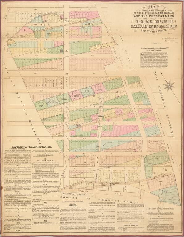
Antique Map of Greenwich Village, Focusing on the Area Between Washington Square Park and Union Square. This is a John Bute Holmes 1882 cadastral map of eastern Greenwich Village, one of New York City's most famous neighborhoods, the cradle of the...