logo

1891. Map of the State of California Compiled Expressly for Thos. H. Thompson, Publisher Tulare, Cal. Issued with the Tulare County Atlas

  • Map of the State of California Compiled Expressly for Thos. H. Thompson, Publisher Tulare, Cal. Issued with the Tulare County Atlas

Map of the State of California Compiled Expressly for Thos. H. Thompson, Publisher Tulare, Cal. Issued with the Tulare County Atlas information:

Year of creation: 
Resolution size (pixels): 
 9120x17031 px
Disk Size: 
 52.1963MiB
Number of pages: 
 1
Place: 
 San Francisco
Author: 

Print information. Print size (Width x height in inches):
Printing at 72 dpi 
  126.67 х 236.54
Printing at 150 dpi 
 60.8 х 113.54
Printing at 300 dpi 
 30.4 х 56.77

An example of detailing the file of this map of in a printable high-resolution:

Click to open in high resolution (open in new tab).
Attention! this is just the central piece (central area 960x960 px) of the map file!
This is an example, so that you can see and study the level of detail of a given map. The entire Map will be fully available after payment!

Map of the State of California Compiled Expressly for Thos. H. Thompson, Publisher Tulare, Cal. Issued with the Tulare County Atlas

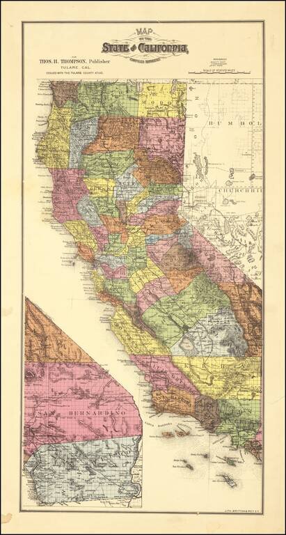
Scarce map of California, colored by counties. which appeared in Thompson's Atlas of Tulare County.

The map shows California with completed township surveys. Orange County is present, but Riverside and Imperial Counties are still not yet formed.

Rarity

This is the second time we have offered the map for sale in 20 years.


Special conditions for students!

If you are a student, write to us in telegram: @antiquemaps and indicate what material you need and for what work you need a map in high detail. We are ready to provide material on special terms. For students only!

Item information:

Year of creation:
Size:
9120x17031 px
Disk:
52.1963MiB
Number of pages:
1
Place:
San Francisco
Author:
Britton & Rey.
$14.99

Related item