Map size in jpg-format: 41.3363MiB
Click to open in high resolution (open in new tab).
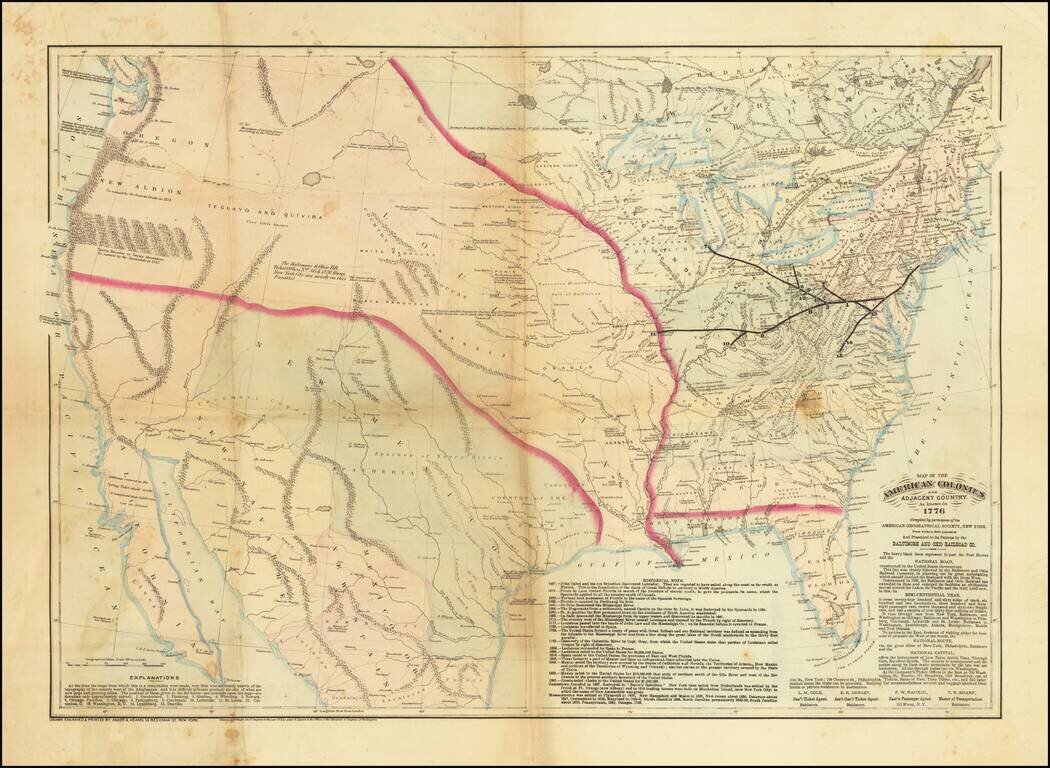
A Wonderful Centennial Map. The United States as it was known in 1776 - from the perspective of 1876.
Very scarce hand-colored lithographed map of the United States, prepared by Asher & Adams for the Baltimore & Ohio Railroad, presumably for the Centennial of American Independence.
This is essentially a compilation map of the United States in 1776 but compiled by Asher & Adams 100 years later using maps at the American Geographical Society. For the viewer in 1876, this would have been an entrancing map, representing just how far the country had come in 100 years. The map shows a country that is almost wholly unexplored and unknown, with even the East Coast (Florida in particular) barely known when compared with the late 19th century. An explanation of the map is included in the lower-left corner:
At the time the maps from which this is a compilation were made, very little was accurately known of the topography of the country west of the Alleghenies and it is difficult to locate precisely the site of what are now large and growing cities. The position of those given in the list below--see numbers upon the map -- are therefore only approximately correct. 1. Cumberland. 2. Pittsburg. 3. Grafton. 4. Wheeling. 5. Newark. 6, Chicago Junction. 7. Chicago. 8 Parkersburg, 9. Cincinnati. 10. Louisville. 11. St. Louis. 12. Columbus, O. 13. Washington, D,C. 14. Lynchburg. 15. Danville.
The Baltimore & Ohio Railroad chose this kind of historical map in part because it showed what an important role the company had played in the settling of the country. A note on the map says of the railroad:
Commenced in 1826, the Baltimore and Ohio Railroad has extended its lines and enlarged its facilities as civilization has moved toward the Lakes, the Pacific and the Gulf, until now, in this, its SEMI-CENTENNIAL YEAR (i.e., 1876), it owns twenty-four hundred and sixty miles of track, six hundred and two locomotives, three hundred and forty-eight passenger cars, twelve thousand and sixty-two freight cars, and has a surplus of over thirty-four million dollars.
Historical cartography provides insight not only into the past but also into the perspectives of those who made the maps. This map says much about the outlook and values of Americans on the advent of the First Centennial.
Asher & Adams was a New York publishing firm known for their atlases. Notably, their maps were some of the first to prominently exhibit railroad lines, even if this meant a slight reduction in topographical detail. They specialized especially in state and county maps of the United States.
If you are a student, write to us in telegram: @antiquemaps and indicate what material you need and for what work you need a map in high detail. We are ready to provide material on special terms. For students only!

![[Signed Political Satire Artwork] Vietnam ... Vietnam ... Vietnam ...](/map/small/68726.jpg)
