logo

1901. Map of Portions of Lower Clear Creek and Gilpin Counties Showing Mining Claims in the Vicinity of Idaho Springs, Colorado. Prepared From Official Surveys and Records By James Underhill Mining Engineer -- U.S. Dep. Min. Surveyor Idaho Springs, Colorado

  • Map of Portions of Lower Clear Creek and Gilpin Counties Showing Mining Claims in the Vicinity of Idaho Springs, Colorado.  Prepared From Official Surveys and Records By James Underhill Mining Engineer -- U.S. Dep. Min. Surveyor  Idaho Springs, Colorado

Map of Portions of Lower Clear Creek and Gilpin Counties Showing Mining Claims in the Vicinity of Idaho Springs, Colorado. Prepared From Official Surveys and Records By James Underhill Mining Engineer -- U.S. Dep. Min. Surveyor Idaho Springs, Colorado information:

Year of creation: 
Resolution size (pixels): 
 24532x21484 px
Disk Size: 
 96.8481MiB
Number of pages: 
 1
Place: 
 Idaho Springs, Colorado
Author: 

Print information. Print size (Width x height in inches):
Printing at 72 dpi 
  340.72 х 298.39
Printing at 150 dpi 
 163.55 х 143.23
Printing at 300 dpi 
 81.77 х 71.61

An example of detailing the file of this map of in a printable high-resolution:

Click to open in high resolution (open in new tab).
Attention! this is just the central piece (central area 960x960 px) of the map file!
This is an example, so that you can see and study the level of detail of a given map. The entire Map will be fully available after payment!

Map of Portions of Lower Clear Creek and Gilpin Counties Showing Mining Claims in the Vicinity of Idaho Springs, Colorado.  Prepared From Official Surveys and Records By James Underhill Mining Engineer -- U.S. Dep. Min. Surveyor  Idaho Springs, Colorado

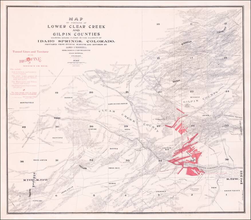
Rare separately published map of the area around Idaho Springs, Colorado, as surveyed by James Underhill.

The map extends from Idaho Springs to Lamartine and Downieville and north to Central City, identifying the locations of hundreds of mining claims.

The map identifies the Tunnel Lines and Territory of the Big Five, which includes:

  • The Central and Georgetown Tunnels
  • The entire water power of the Clera Creek and the Belman Mine
  • The Miami Mines and Wilcox Tunnel
  • The Edgar Consolidated Mines

Special conditions for students!

If you are a student, write to us in telegram: @antiquemaps and indicate what material you need and for what work you need a map in high detail. We are ready to provide material on special terms. For students only!

Item information:

Year of creation:
Size:
24532x21484 px
Disk:
96.8481MiB
Number of pages:
1
Place:
Idaho Springs, Colorado
Author:
James Underhill.
$21.99

Related item