Map size in jpg-format: 24.2831MiB
Click to open in high resolution (open in new tab).
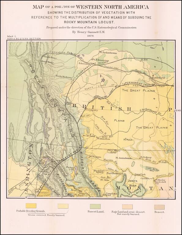
Detailed Vegetation Map of northern Montana, Idaho, Western Washington and contiguous parts of Alberta and British Columbia, from the Second Report of the United States Entomological Commission for the years 1878 and 1879.
The map is relatedto the Rocky Mountain Locust, and the Western Cricket and treating of the best means of subduing the locust in its permanent breeding grounds, with a view of preventing its migrations into the more fertile portions of the trans-Mississippi country, in pursuance of appropriations made by Congress for this purpose.
Locates nearly all the forts ever constructed in the Rocky Mountain West. Also all railroads, built or projected. Centers on the North Platte River.
No specimen of this species (Melanoplus spretus), the swarming phase of the short-horned grasshopper, has been collected since at least 1899. Like the Passenger Pigeon, an amazing extinction.
Handsome topo map where Black Hills and Rocky Mountains stand out from plains. Shows extent of RR development, forts and Indian agencies (as their rights had been eradicated as surely as the locusts).
If you are a student, write to us in telegram: @antiquemaps and indicate what material you need and for what work you need a map in high detail. We are ready to provide material on special terms. For students only!